About Us
Established in 1932 as a migratory bird refuge, the refuge's original objectives were to conserve in public ownership habitat for waterfowl, shorebirds and seabirds, and resident species. Over the years, objectives expanded to include: managing threatened and endangered species, protecting the 29,000-acre Class 1 Wilderness Area, conserving the maritime forests and associated diverse plant communities, and offering wildlife-oriented recreation when compatible with refuge purposes. Outdoor recreation opportunities on the refuge include fishing, hunting, photography, wildlife observation, interpretation and environmental education.
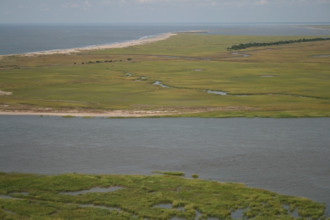
The refuge consists of 66,306 acres, comprising barrier islands and salt marsh salt marsh
Salt marshes are found in tidal areas near the coast, where freshwater mixes with saltwater.
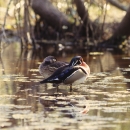
Learn more about salt marsh . The barrier islands of Cape Romain are part of a dynamic coastal system that are continually shaped by erosion and sedimentation, storms, and sea level rise. Sub-tropical maritime forest, long sandy beaches, and fresh and brackish water impoundments are found on the islands. Over 2000 acres of maritime forest is dominated by magnolia, cabbage palm and loblolly pine with an understory of red bay, yaupon holly, wax myrtle, and saw palmetto. Shrub habitat found on forest edges is used by neotropical migratory and resident songbirds, and is excellent nesting habitat for Painted buntings. White-tailed deer, bobcat, raccoon, and black fox squirrels find haven in the forest and shrub habitats on Bulls Island.
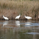
Dunes, beaches, and sand bars are important for migratory birds as loafing and roosting habitat. Even more critical for shorebirds are the invertebrates the habitats support. Piping plovers feed on marine worms, sand fleas and other amphipods during their spring and fall migrations. Horseshoe crab eggs provide excellent food resources for the Red knot, American oystercatcher, and Marbled godwit. Other food sources include coquina clams, surf clams, angel wing, arc, and mollusks. Fiddler crabs and ghost shrimp are other sources for birds like Wilson’s plover, Gull-billed tern, Long-billed curlew and Whimbrel.
Cape Romain NWR is mostly seventy-five percent estuary with the seemingly endless emergent salt marshes that are dominated by smooth cordgrass and interwoven with winding tidal creeks, shallow bays, shell rake islands and salt flats. These estuarine wetlands are significant nursery habitats. The incoming tide carries juvenile fish, crabs, shrimp and other invertebrates. Combining the ocean’s nourishment with the nutrient-laden fresh waters of small rivers makes the estuary one of the most productive environments on earth. When the tide recedes, these small aquatic animals are often trapped in pools which provide excellent foraging opportunities for birds and other wildlife.
The refuge visitor center, the Sewee Visitor and Environmental Education Center, is located in the town of Awendaw on Highway 17 North. Opened in 1996, the Center showcases the ecosystems of Cape Romain and the Francis Marion National Forest, and offers recreation and education opportunities for all ages. Visit the Red Wolf viewing area and pollinator areas, walk the Nebo Trail, picnic at the shelter, enjoy interactive exhibits and participate in nature programs, and browse the nature store. At the Center you can pick up brochures and recreation guides for the refuge and forest. Partners are the Francis Marion NF and Friends of Coastal South Carolina.
Special Designations
One of 500 Important Bird Areas by the American Bird Conservancy
Designated critical habitat for the federally listed Piping plover
A Western Hemisphere Shorebird Reserve Network Site of International Importance. Expanded to encompass the Cape Romain-Santee Delta Region WHSRN Site of International Importance
Part of the Carolinian-South Atlantic Biosphere Reserve
A Class I National Wilderness Area for 29,000 acres
Cultural History of Cape Romain
From the Sewee Indians to pirates, from a look-out tower to two nineteenth-century lighthouses, Cape Romain National Wildlife Refuge houses a rich history across the refuge's maze of tidal creeks, marshes, and barrier islands.
The Native American Sewee tribe inhabited the Cape Romain area before the arrival of European settlers. The tidal creeks and bays provided the natives with ample supplies of fish, oysters, and clams. Today, you see the archeological remains of several native "middens" (piles of shell remains) that are located along the hiking trails on the bay side of Bulls Island. When English settlers in South Carolina made their first landing in the New World, they were greeted by the island's Sewee Indians. The settlers replenished their stocks of wood, water, and food before proceeding further south where they eventually established the first permanent European settlement in South Carolina at the present city of Charleston.
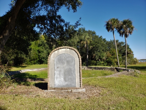
Bulls Bay and the creeks behind Bulls Island were reputed hideouts for pirates raiding and plundering ships along the coast, especially as this area was close to the port of Charleston. The tabby foundation remains of the Old Fort on Bulls Island was a look-out tower armed with cannon, built in the early 1700s to warn mainland settlers of approaching strange ships. During the Civil War, Confederate blockade runners used refuge tidal creeks and troops used the Old Fort as a powder magazine. On December 28, 1862 "...the first cutter with an armed crew and 70 pounds of powder was sent to destroy the fort on Bulls Island. At 1 p.m. the boat returned having destroyed the magazine shell room and set fire to all the woodwork"...Lt. Com Uphur of the U.S. Navy, USS Flambeau.
In 1925, Gayer Dominick, a wealthy businessman and avid hunter from New York, NY, purchased Bulls Island with the intent of making it a private hunting preserve. He had the "Dominick House" built and made improvements to the island's existing impoundments to attract waterfowl. In 1936, Mr. Dominick conveyed the island to the Service to become part of the refuge. For years, the house was operated by contracted private concessions as a bed and breakfast of sorts, where visitors were given lodging and three meals daily. Bird researchers and nature-lovers came and stayed on the island to birdwatch and observe other wildlife, hunt, fish, beachcomb and relax. Currently, the refuge works with the concession to offer three-day weekend ecology and history excursions with lodging at the Dominick House.
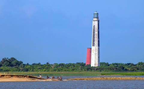
Two 1800s lighthouses still stand as maritime sentinels over the inshore waters and refuge estuary surrounding Lighthouse Island. When early sailors came down the coast to the port of Charleston, they encountered shoals lying just under the water level nine miles from Cape Romain islands. Many ships were wrecked on the shoals. In 1827, the first lighthouse was constructed. The conical tower stood 65 feet above high water and had a stationary light directed at the shoals. The lamp, powered by a whale oil wick, could be seen for 14 miles but it proved to be ineffective,and another lighthouse was built in 1857. The new octagonal tower rose 154 feet. The lamp was oil but with a new prismatic lens, one of the earliest Fresnel systems installed in the United States. The light could be seen for 19 miles offshore and shipwrecks decreased dramatically.
From 1827 until the 1930’s, keepers and assistants lived on the remote island with their families in order to have daily access to the lighthouses. In 1933, the oil lamp was replaced by an electrical system which used large batteries to power the light and resident lighthouse keepers were no longer necessary. During the Civil War the light was abandoned, though both Union ships patrolling the blockade and Confederate blockade runners used them as landmarks. During World War II, the U.S. Coast Guard used the lighthouse and keeper’s house as an observation post. Except for those two periods, the 1857 light served mariners until it was decommissioned in 1947. Local recreational and commercial boaters have through history and continue to use the lighthouses as fixtures on the flat horizon to navigate around the island and hammocks in the area. The 1827 tower is one of the oldest lighthouses still standing in the country. The Cape Romain lighthouses were listed on the National Register of Historic Places in 1980.
Wilderness Area
Cape Romain Wilderness
- Designated in 1975 as Class I Wilderness
- 29,000 acres
The Wilderness Act of 1964 created the National Wilderness Preservation System "in order to assure that an increasing population, accompanied by expanding settlement and growing mechanization, does not occupy and modify all areas in the United States, and its possession, leaving no lands designated for preservation and protection in their natural condition..."
Cape Romain Class I Wilderness distinction recognizes this area as having some of the cleanest air on the east coast. The Class I Wilderness Air Quality designation provides protection from future air pollution under the Clean Air Act.
Cape Romain Wilderness is a vital refuge for over 293 species of birds, host to one of the largest rookeries for Brown pelicans and terns on the South Carolina coast, and has the largest wintering population of American oystercatchers on the East coast. The threatened Piping plover frequents refuge beaches during its migration in the spring and fall. Cape Romain's beaches are the site of the largest nesting population of the threatened Loggerhead sea turtle outside the state of Florida.
"Something will have gone out of us as a people if we ever let the remaining wilderness be destroyed."
Wallace Stegner
For more information about Cape Romain Wilderness, visit wilderness.net.
Our Mission
Refuge Purpose
Each unit of the National Wildlife Refuge System is established to serve a statutory purpose that targets the conservation of native species dependent on its lands and waters. All activities on those acres are reviewed for compatibility with this statutory purpose.
Recognizing the high migratory bird benefits and recreational opportunities served by the lands and waters of the refuge, Cape Romain NWR was established under the Migratory Bird Conservation Act, the Fish and Wildlife Act, and the Refuge Recreation Act, thus outlining the primary purposes of these lands and waters:
“for use as an inviolate sanctuary, or for any other management purpose, for migratory birds.” 16 U.S.C. 715d…“to conserve and protect migratory birds…and other species of wildlife that are listed…as endangered species or threatened species and to restore or develop adequate wildlife habitat.” 16 U.S.C. 715i (Migratory Bird Conservation Act)
“for the development, advancement, management, conservation, and protection of fish and wildlife resources.” 16 U.S.C. 742f(a)(4) “…for the benefit of the United States Fish and Wildlife Service, in performing its activities and services. Such acceptance may be subject to the terms of any restrictive or affirmative covenant, or condition of servitude.” 16 U.S.C. 742f(b)(1) (Fish and Wildlife Act of 1956)
“suitable for (1) incidental fish and wildlife-oriented recreational development, (2) the protection of natural resources, (3) the conservation of endangered species or threatened species...” 16 U.S.C. 406k-2 (Refuge Recreation Act (16 U.S.C. 406k-406k-4), as amended)
“so as to provide protection of these areas…and to ensure…the preservation of their wilderness character.” (Wilderness Act of 1964, Public Law 88-577)
Our History
1932 - Established in 1932 as a refuge for migratory waterfowl and other bird species
1936 – Bulls Island, privately owned by Gayer Dominick, was conveyed to the Service to become the southern-most barrier island in Cape Romain NWR
1975 – 29,000 acres Congressionally designated as Class I National Wilderness Area
1980 – 1827 and 1857 lighthouses placed on the National Register of Historic Places
1995 – Refuge designated a Western Hemisphere Shorebird Reserve Network Site of International Importance
1996 – Sewee Visitor and Environmental Education Center opens. Partners are Friends of Coastal South Carolina and Francis Marion National Forest
Other Facilities in this Complex
Encompassing over 115,000 acres, South Carolina Lowcountry Refuges Complex is home to four national wildlife refuges located in the coastal area known as the Lowcountry, the low lands extending from the Atlantic Ocean to the western sandhills. These public lands comprise some of the most unique and biologically diverse wetland and upland ecosystems along the Atlantic Coast. , Other than Cape Romain NWR, the Complex includes Ernest F. Hollings ACE Basin NWR,one of the largest undeveloped estuarine wetland systems remaining along the U.S. Atlantic coast, Waccamaw NWR, a critically endangered longleaf pine forest ecosystem and, Santee NWR, the only known maritime sandhill community in the state.