


What We Do
Wildlife conservation is at the heart of the National Wildlife Refuge System. It drives everything on U.S. Fish and Wildlife Service lands and waters managed within the Refuge System, from the purposes for which a national wildlife refuge national wildlife refuge
A national wildlife refuge is typically a contiguous area of land and water managed by the U.S. Fish and Wildlife Service for the conservation and, where appropriate, restoration of fish, wildlife and plant resources and their habitats for the benefit of present and future generations of Americans.
Learn more about national wildlife refuge is established to the recreational activities offered to the resource management tools used. Using conservation best practices, the Refuge System manages Service lands and waters to help ensure the survival of native wildlife species.
Refuges deploy a host of scientifically sound management tools to address biological challenges. These tools span active water management to wilderness character monitoring, all aimed at ensuring a balanced conservation approach to benefit both wildlife and people. At this field station our conservation tool box includes:
Invasive Species
Refuge staff are founding members of the Long Island Invasive Species Management Area. Networking with other members and attending periodic public meetings has helped us realize the most problematic non-native species, develop mapping standards, prioritize treatment regimens and prepare outreach materials.
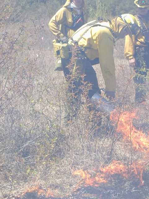
Prescribed Fire
This management technique benefits a variety of natural resources. In areas where prescribed fire has been used, the refuge has been able to reduce the natural buildup of fuels offering better protection from wildfire and restore a natural ecological process to wildlands. Burning helps to maintain fire dependent vegetation (pitch pine, warm seasonal grasses), manage grasslands, remove non‑native plants and improve feeding and nesting areas for wildlife.
Wetland Monitoring
The U.S. Fish and Wildlife Service is working with the U.S. Geological Survey on a salt marsh salt marsh
Salt marshes are found in tidal areas near the coast, where freshwater mixes with saltwater.
Learn more about salt marsh integrity study to develop protocols to measure important components in marsh habitats such as vegetation, soils and wildlife use. The study results will help to inform refuge staff on how we can sustain these critical habitats in the challenge of environmental threats such as storm events, habitat loss and sea level rise.
Bat Monitoring
The refuge has been involved in both acoustic monitoring and mist netting of bats. Acoustic monitoring is the process of recording bat echolocations in the wild for the purposes of understanding how many and what types of bats reside in an area. Mist netting is a popular and important tool for monitoring species diversity, relative abundance, and population size in birds and bats. In 2021, biologists successfully caught red bats (Lasiurus borealis), big brown bats (Eptesicus fuscus) and a northern long-eared bat (Myotis septentrionalis)!
Management and Conservation
Management Goals
Refuge management goals are:
- Provide and manage a diversity of high quality habitats to support breeding, migrating and/or wintering birds, threatened & endangered species and fish.
- Maintain high quality habitats for all native wildlife and plant species.
- Establish and maintain partnerships to benefit wildlife for present and future generations.
Our Services
At this field station we offer a variety of public recreation opportunities, including hunting, fishing, paddling, hiking, wildlife observation, nature photography, interpretive programs and environmental education.
Our Projects and Research
Current Projects Include
Wertheim is a stopover location for migratory birds in the spring, summer and fall. Wertheim is home to the “Big Fish Impoundment” which employs a ‘stoplog’ water control structure to manage water levels to optimize foraging habitat. Biologists complete a biweekly survey is completed to document water level and record the species utilizing the impoundment. This year, black skimmers, glossy ibis, common terns, least terns, among others were seen foraging and roosting on the tidal flats.
Refuge staff, Long Island Field Office staff and Student Conservation Association interns conduct annual rare plant surveys each August. The Sayville grasslands continue to support the largest population of the federally endangered sandplain gerardia (Agalinus acuta) on Long Island. Service staff also survey the seabeach knotweed (Polygonum glaucum) population at the Elizabeth A. Morton refuge. This plant is rare in New York and found on maritime beaches, adjacent dunes and saltmarshes.
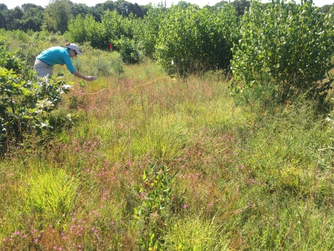
Refuge staff and Student Conservation Association interns completed saltmarsh vegetation surveys at Wertheim, Seatuck, and Lido Beach each August and September. The team surveys 203 one-meter square quadrats to assess how the salt marsh salt marsh
Salt marshes are found in tidal areas near the coast, where freshwater mixes with saltwater.
Learn more about salt marsh is responding to restoration efforts. During the surveys, the team records percent cover, stem density, and stem height. Hurricane Sandy resiliency projects involve the use of coir logs to fill former mosquito ditches, newly excavated channels to improve tidal flow, thin layer deposition, and a new living shoreline.
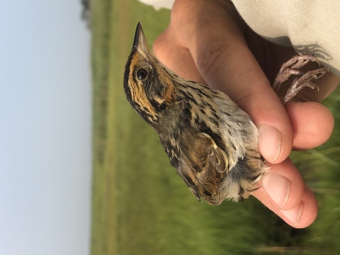
Refuge staff assist researchers with the Saltmarsh Habitat & Avian Research Program (SHARP) in their survey at Wertheim. The team use mist nests to capture, measure and band adult saltmarsh sparrows on the refuge. This research and banding are part of a larger effort to document the population range and density of the at-risk saltmarsh sparrow. Biological technicians monitor critical sparrow habitat and other habitat variables in the tidal marshes at Wertheim and throughout the Long Island NWR Complex through Hurricane Sandy Coastal Resiliency efforts.
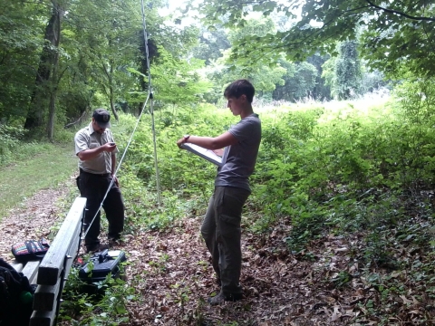
Refuge staff work with the regional forester to complete a forest inventory at Wertheim. The refuge has approximately 1,300 acres of forested habitat and includes 54 sampling plots. During the inventory, biologists collect baseline data on forest composition, structure and health, which will help to inform management decisions. Wertheim is one of several refuges participating in this regional inventory and monitoring effort.
Law Enforcement
The mission of the National Wildlife Refuge System Law Enforcement program is:
"Through education and enforcement we protect our employees, volunteers, and visitors; safeguard the public’s investment in facilities and equipment; and protect the integrity of the habitat and the wildlife resources of the National trust resource which is the 150 million acre National Wildlife Refuge System.”
Laws and Regulations
To protect the natural resources of the refuge and to provide all visitors with a safe and enjoyable wildlife experience, please observe all refuge signs and regulations in handouts and brochures.