


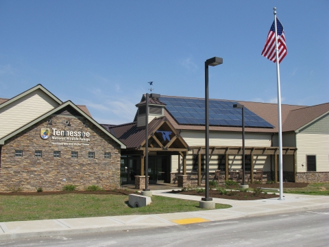
Headquarters/Visitor Center
The Headquarters/Visitor Center is open 8 am - 4 pm Monday through Saturday. We are closed on all Federal holidays.
1371 Wildlife Drive
Springville, TN 38256
(731) 642-2091
Fax: (731) 644-3351
Directions: From highway 79 North of Paris, take Oak Grove Road South and follow directional signs 7 miles to visitor center.
GPS Coordinates: -88.1267 36.3313
Other Points of Interest
Big Sandy Unit:
V.L. Childs Observation Deck
Near the new visitor center, this deck provides year round views of wildlife in a bay of Kentucky Lake, complete with binoculars and interpretive signs.
Britton Ford Hiking Trail
Located just one mile from the visitor center, this 2.5 mile moderate hiking trail is open seasonally from March 16th through November 14th.
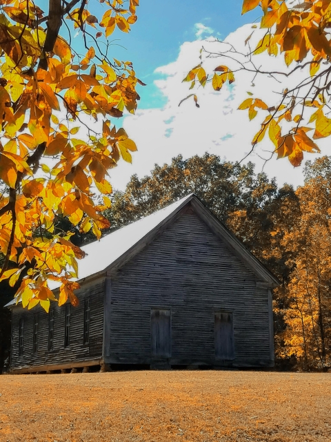
Mt. Zion Church
Located on Big Sandy Peninsula. Take Lick Creek Road 13 miles north of the town of Big Sandy. This old church built in 1898 still stands as a reminder of the community that once thrived here.
Bennett's Creek Observation Deck
Just past Mt. Zion church on the Big Sandy Peninsula. Open year round with spotting scopes. A good location to view bald eagles in the winter.
Chickasaw National Recreation Trail National Recreation Trail
A National Recreation Trail is a land-based or water-based trail that provides an outdoor recreation opportunity on federal, state, tribal or local public land. National Recreation Trails were established by the National Trails System Act of 1968 (Public Law 90-543), which authorized creation of a national trails system composed of National Recreation Trails, National Scenic Trails and National Historic Trails. Whereas National Scenic Trails and National Historic Trails may be designated only by an act of Congress, National Recreation Trails may be designated by the Secretary of the Interior or the Secretary of Agriculture to recognize exemplary trails of local and regional significance.
Learn more about National Recreation Trail
On the Big Sandy Peninsula. Take Lick Creek Road 13 miles north of the town of Big Sandy. This 1.2 mile easy hiking trail is open year round and features rock tread, benches and interpretive signs.
Duck River Unit:
Pintail Point Observation Blind
Located in the Duck River Bottoms, this blind is open year round. In New Johnsonville, take Long Street off highway 70 and follow the directional signs.
Blue Goose Boulevard Interpretive Drive
In Duck River Bottoms off Refuge Lane. Open seasonally from March 16th through November 14th, this 3 mile drive allows visitors to view wildlife with interpretive signs.

Duck River Bottoms Overlook
Off Birdsong Road or Highway 191. Open year round providing an excellent view overlooking the river and Duck River Bottoms. The deck is located at the end of 1/4 mile hiking trail.
Key Contacts
