


Visit Us
Silvio O. Conte National Fish and Wildlife Refuge offers a number of locations to visit:
Nulhegan Basin Division
5396 Rte. 105
Brunswick, Vermont 05905
Phone: 802-962-5240
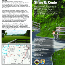
The Nulhegan Basin Division is located in the most remote part of Vermont in the towns of Brunswick, Ferdinand, Bloomfield, and Lewis. The division headquarters and visitor contact station is located in Brunswick (about 10 miles east of Island Pond). Refuge lands consist of more than 26,600 acres of conifer and deciduous forest interspersed with forested wetlands, peatlands and shrub swamps, and contain three of the four tributaries of the Nulhegan River. These lands are nested within a working forest landscape exceeding 150,000 acres. Located just a few miles south of the Canadian border, the basin’s vegetation most closely resembles that of the northern Appalachian Mountains, interspersed with elements of the boreal forest to the north. This division is known for abundant songbirds, particularly boreal species and warblers, and has been designated an Important Bird Area by the National Audubon Society. It is open to the public for hunting, fishing, wildlife observation and photography, environmental education, and interpretation.
Public Use Points:
- Visitor Contact Station with exhibits and restroom facilities. The contact station is open daily, 365 days a year.
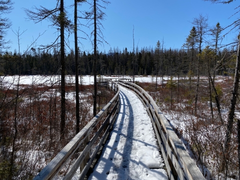
- Mollie Beattie Bog Accessible Boardwalk.
- Nulhegan River Trail: a 1-mile interpretive loop departing from the visitor contact station. This is a rustic trail with stone steps and "bog" bridges. This trail is accessible year-round, and is suitable for snowshoeing.
- North Branch Trail: a 4-mile loop bordering the North Branch of the Nulhegan River. It is also a rustic trail and is accessible year-round from a parking area on Vermont Route 105. In addition to snowshoeing, certain segments are also suitable for cross-country skiing.
- Lewis Pond: Scenic pond; fishing; paddling.
- Scenic overlooks at the visitor contact station and Lewis Pond.
- The Kingdom Heritage Trail is a 20 mile back country trail with scenic vistas. The Trailhead is at the Lewis Pond Overlook. The trail connects to downtown Island Pond.
- On an annual basis, the roads at the Nulhegan Basin Division are closed to motor vehicle traffic (excluding snowmobiles) from December 16th to the Friday before Memorial Day weekend. The road system on the refuge is seasonally closed to protect the infrastructure from excessive wear and tear. During that time period, the public may use the roads to explore the refuge on foot, by bicycle, on skis/snowshoes, or by snowmobile (on groomed VAST trails). The use of ATVs/ORUVs and dirt bikes are prohibited on the refuge.
- Nulhegan Basin General Brochure
- Nulhegan Basin Rack Card
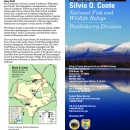
Pondicherry Division
289 Airport Road
Whitefield, New Hampshire 03598
Phone: 802-962-5240
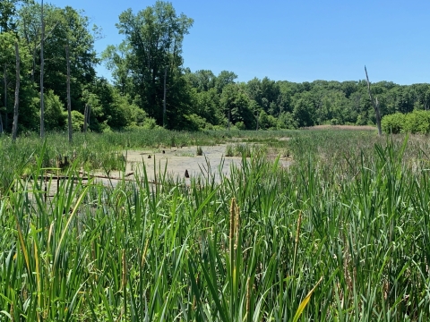
The 6,405 acre Pondicherry Division is located in Jefferson, Whitefield, and Carroll, New Hampshire, 5 miles south of Lancaster, New Hampshire, and twelve miles northwest of Mount Washington.
This area, including Cherry and Little Cherry Ponds and the surrounding complex of wetlands and swamps, has long been known for its high quality habitat and rich, diverse assemblage of wildlife species, particularly birds. In 2004, the Pondicherry area was designated the first Important Bird Area in New Hampshire for its rich variety of breeding and migrating birds.
Within the bounds of the division are three ponds (Cherry Pond, Little Cherry Pond, and Mud Pond), and a complex mix of habitats including boreal forests, forested bogs, northern hardwoods/conifers, riparian riparian
Definition of riparian habitat or riparian areas.
Learn more about riparian communities, an abundance of early successional vegetation, and open water. This concentration of diverse, high quality habitats acts as a magnet to wildlife.
There are five trails located within the Pondicherry Division. The Mud Pond Trail is a 0.6 mile wheelchair accessible trail. The Little Cherry Pond Trail, the Shore Path Trail, and the Rampart Path are located in the center of the division and are accessible from the Presidential Recreational Trail managed by the New Hampshire Bureau of Trails. This rail-trail can be accessed from trail heads on Airport Road and Route 115A in Jefferson.
Pondicherry has been recognized for its ecological importance through its designation as National Natural Landmark National Natural Landmark
The National Natural Landmarks Program preserves sites illustrating the geological and ecological character of the United States. The program aims to enhance the scientific and educational value of the preserved sites, strengthen public appreciation of natural history and foster a greater concern for the conservation of the nation’s natural heritage. The program was established in 1962 by administrative action under the authority of the Historic Sites Act of 1935. The first National Natural Landmarks were designated in 1963. Today, there are more than 600 National Natural Landmarks in 48 states, American Samoa, Guam, Puerto Rico and the U.S. Virgin Islands.
Learn more about National Natural Landmark . Two of the trails (Little Cherry Pond Trail and Mud Pond Trail) are National Recreation Trails.
This division is open to the public for hunting, fishing, wildlife observation, photography, environmental education, and interpretation.
- Mud Pond Trail (located in Jefferson, NH) is a 0.6 mile wheelchair accessible trail.
- State Trailhead leading to Cherry Pond & the southern part of the refuge
- The Little Cherry Pond Trail, Shore Path Trail, and Rampart Path are located in the center of the division and are accessible from the Presidential Recreational Trail managed by the New Hampshire Bureau of Trails. This rail-trail can be accessed from trail heads on Airport Road and Route 115A in Jefferson.
Pondicherry Division Rack Card
Fort River Division
69 Moody Bridge Road
Hadley, MA 01035
Phone: 413-687-3588
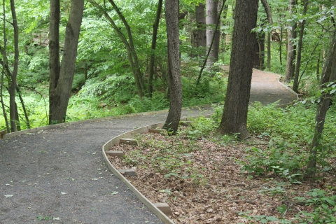
The mile-long, fully accessible trail at Fort River allows visitors an up-close and personal look at diverse wildlife and habitats. The trail meanders through a series of successional habitats from grasslands to upland forest and provides important habitat for fish, grassland birds and a variety of herps and mammal species. Please note, visitors can access the trail via the intersection at Bay Road. The South Maple Street intersection with Moody Bridge Road is closed to through traffic.
Public use points:
- One-mile long accessible loop trail that meanders through diverse successional habitat.
- Scenic overlooks and resting benches located throughout the trail.
- Parking available at the head of the trail.
- Excellent location for wildlife observation and photography.
- Fort River Birding and Nature Trail Rack Card
Fannie Stebbins Unit
Pond View Road
Longmeadow, MA 01106
Phone: 413-687-3588
The Fannie Stebbins property and the larger floodplain area known as the "Longmeadow Flats" has been designated as a National Natural Landmark by the U.S. Department of the Interior, and an Important Bird Area by the Massachusetts Audubon Society. The nearly 400-acre area hosts many animals and plants, and includes scenic ponds, abundant wetlands, tree and shrub swamplands, open meadows, mixed-hardwood forest and riverbank. The diverse habitat provides breeding habitat and stop-over habitat for a great variety of birds, including migratory waterfowl. Periodic flooding preserves one of the largest remaining patches of floodplain forests and wetlands along the Connecticut River.
The Unit is open to the public for wildlife observation, photography, fishing, and hiking. It is open year round from sun-up to sun-down. Please note: Hunting is not permitted at the Fannie Stebbins Unit.
Public Use Points:
- Excellent location for wildlife watching and photography.
- An accessible overlook is located off Pondside Road.
- Fannie Stebbins Rack Card
Know Before You Go
Due to the large area that the Silvio O. Conte National Fish & Wildlife Refuge covers, one can expect large variations in seasonal weather, temperature, and insects. The following suggestions are intended to help make your visit pleasant and enjoyable. It is highly recommended that you check the local weather forecast for the Division or Unit that you are visiting on the day that you depart.
Items to consider are:
Appropriate, comfortable clothing
Comfortable walking or hiking footwear
Sunglasses
Sunscreen
Water
Insect repellent in late spring, summer, and early fall
Emergency announcements of closures or other safety conditions will be posted on the refuge’s home page.
In an emergency – Dial 911!
Dial 911 in an emergency while at the refuge. This will connect you with the local police department. Be prepared to provide dispatch with the following information:
My emergency is: state the emergency
I am at [Division or Unit name] of the Silvio O. Conte National Fish & Wildlife Refuge
I am located on the “. . . Trail, Boardwalk, etc.
If you make an emergency call, please stay on the phone until dispatch says you can hang up! The refuge is large and dispatch may need to track you by using your phone signal or verbal assistance from you.
Activities
Silvio O. Conte National Fish and Wildlife Refuge offers a number of different outdoor recreational activities throughout all of its 22 locations, including hunting, fishing, wildlife observation, photography, environmental education and interpretation. Some of our Divisions allow bicycle riding, but check the rules for individual Divisions before you go.
Trails
There are many trails throughout Conte Refuge locations where you can walk, hike and bike. Each location has different accessibility levels and regulations, so be sure to check ahead of time regarding the specific location you are visiting.
All hiking areas on the refuge are open year-round from one half hour before sunrise to one half hour after sunset.
Nulhegan
Visitors may view and photograph wildlife in a variety of settings such as along the forty miles of gravel roads, walking along wooded pathways, following stream courses, or while hiking in the deep woods. Many areas on the division provide scenic vistas of the Nulhegan Basin and the surrounding mountains. Visitors can access the Division's lands and vistas by passenger vehicle, snowmobile, or on foot (or cross country skis or snowshoes in winter) to enjoy wildlife observation and photography.
Winter Recreation at the Nulhegan Basin Division- Vermont
Every year roughly 25 miles of gravel roads at the Nulhegan Basin are groomed by local snowmobile clubs to provide winter recreation opportunities. The groomed trails on the wildlife refuge are used for snowmobiling, cross country skiing and snowshoeing. Individuals using Snowmobiles on the trail system must have a their machines registered, insured and obtain a VAST trail pass (TMA). The maximum speed limit on the wildlife refuge and state lands is 35 m.p.h.
The snowmobile season in Vermont is December 16th to April 15th.
At the end of the season the refuge gates will be closed and locked until Memorial Day weekend.
Nulhegan Basin General Brochure
Putney Mountain
The Putney Mountain unit is located in Putney and Brookline, Vermont. It lies about 20 miles north of the Massachusetts border and 5 miles west of the Connecticut River. The landscape is a northern hardwood forest, consisting mostly of American beech, sugar maple, and yellow birch. Animals that may be found in this habitat include white-tailed deer, black bear, beaver, wood duck, wild turkey, and many species of forest-nesting songbirds. The division is open to the public year round for wildlife observation, photography, environmental education, and interpretation. This unit is popular for bird watching, particularly during the summer nesting season.
Map of trails at Putney Mountain
Directions to Putney Mountain:
Take Exit 4 on I-91 towards Putney, VT. Turn onto Route 5 North (Main Street) for 0.5 miles. Turn left onto Kimball Hill Road for 0.3 miles. Continue onto Westminster West Road for 0.8 miles. Turn left onto West Hill Road for 2.4 miles. Turn right onto Putney Mountain Road for 200 feet. Turn left onto Holland Hill Road for 0.9 miles. Holland Hill Road turns right and becomes Joy Road, stay on this road for 250 feet. Turn left onto Holland Hill Road for 0.9 miles. Turn Right onto Parkman Wood Road for 0.7 miles. Park at the Putney Mountain Unit parking area.
Pondicherry
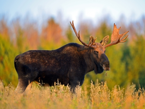
Most visitors come to the Pondicherry Division because it is well known as a place to see moose, bear, a multitude of breeding birds, and spectacular views of the surrounding mountain ranges. People can hike, ski, or snowshoe anywhere on the refuge to view and photograph wildlife, flowers, and the scenery. At this time there are two primitive trails on the refuge. Cherry Pond is linked to Little Cherry Pond by a loop trail that winds through a forested bog community. A series of bog bridges were installed by the Friends of Pondicherry to protect the saturated bog soils. The second trail is a section of the Cohos Regional Trail. It enters the refuge from the east off Whipple Road, leads to Cherry Pond, then exits near Highway 115 in the southeast corner.
Pondicherry Division - The Mooseway
Pondicherry Division - Mud Pond Trail
Pondicherry Division - Main Trail System
Fort River
The mile-long, fully accessible trail at Fort River allows visitors an up-close and personal look at diverse wildlife and habitats. The trail meanders through a series of successional habitats from grasslands to upland forest and provides important habitat for fish, grassland birds and a variety of herps and mammal species. The Fort River Division is located at 69 Moody Bridge Road, Hadley, Massachusetts. Please note, visitors can access the trail via the intersection at Bay Road. The South Maple Street intersection with Moody Bridge Road is closed to through traffic.
View the Fort River Division Brochure
Fannie Stebbins Unit
The Fannie Stebbins property and the larger floodplain area known as the "Longmeadow Flats" has been designated as a National Landmark by the U.S. Department of the Interior, and an Important Bird Area by the Massachusetts Audubon Society. The are is subject to periodic flooding that is representative of this type of habitat. The refuge encompasses one of the largest remaining patches of floodplain forests and wetlands along this heavily human-impacted section of the Connecticut River.
The Unit is open to the public for wildlife observation, photography, fishing, and hiking. It is open year round from sun-up to sun-down. The Fannie Stebbins Unit is located on Pondside Road, Longmeadow Massachusetts.
Related Documents


Other Facilities in the Complex
Refuge Divisions
Currently, the refuge is comprised of nearly 40,000 acres within parts of the four Connecticut River watershed states of New Hampshire, Vermont, Massachusetts, and Connecticut. The refuge includes ten divisions and twelve units that represent a wide variety of unique habitats.
New Hampshire Divisions and Units
Locations
The Silvio O. Conte NFWR has staffed offices located at the Nulhegan Basin Division at 5396 VT Route 105, Brunswick VT 05905 and at the Fort River Division at 69 Moody Bridge Road, Hadley, Massachusetts 01035. Our twenty-three Divisions and Units are spread throughout the watershed in the states of Vermont, New Hampshire, Massachusetts and Connecticut. We also work closely with staff at the Stewart B. McKinney NWR in coastal Connecticut.
For Refuge information, please call 802-962-5240.
For access to the Fort River Division in Hadley, please note: In order to access our this location by vehicle, you will need to use the Bay Road entrance. The South Maple Street entrance to Moody Bridge Road is currently closed to vehicles.
The Nulhegan Basin Division is located in the most remote part of Vermont in the towns of Brunswick, Ferdinand, Bloomfield, and Lewis. The division headquarters and visitor contact station is located in Brunswick (about 10 miles east of Island Pond). Refuge lands consist of more than 26,600 acres of conifer and deciduous forest interspersed with forested wetlands, peatlands and shrub swamps, and contain three of the four tributaries of the Nulhegan River. These lands are nested within a working forest landscape exceeding 150,000 acres. Located just a few miles south of the Canadian border, the basin’s vegetation most closely resembles that of the northern Appalachian Mountains, interspersed with elements of the boreal forest to the north. This division is known for abundant songbirds, particularly boreal species and warblers, and has been designated an Important Bird Area by the National Audubon Society. It is open to the public for hunting, fishing, wildlife observation and photography, environmental education, and interpretation.
Visitor opportunities include formal trails, as well as access to remote areas off trails. Hunting (ruffed grouse, snowshoe hare, deer, and moose), fishing, and bird watching are popular activities.
The Nulhegan Basin Division also contains a visitor contact station (open daily from 8:00am to 4:30pm). Admission to the exhibits is free. Scenic overlooks at the visitor contact station and Lewis Pond provide panoramic views of the Nulhegan Basin.
Nulhegan Basin- Trails and Overlooks
The Nulhegan Basin Division contains forty miles of gravel roads, which accommodate passenger vehicles and are open generally between Memorial Day and mid-December. During the winter, the roads are not plowed, but a network of groomed trails is available for properly registered snowmobiles (VAST TMA required), snowshoeing and cross-country skiing. Call the visitor contact station for the current status of the roads. Bicycles are allowed on gravel roads. Horses and ATVs/ORUVs are not allowed.
Nulhegan Basin Overlook-
The Nulhegan Basin Overlook provides a panoramic view of the Nulhegan Basin and surrounding landscape. The Basin Overlook is accessible from the visitor contact station parking lot and is fully accessible via a short trail leading to the observation area. Located at 5396 VT Route 105, Brunswick VT. The Nulhegan Basin visitor contact station is open 365 days a year from 8:30am to 4:30pm. Exhibits and restrooms are available.
Nulhegan River Trail- https://www.trailfinder.info/trails/trail/nulhegan-river-trail
The Nulhegan River Trail is a 1-mile loop that starts and ends at the Nulhegan Basin visitor contact station. The trail begins at the scenic granite overlook and descends to the Nulhegan River. The trail parallels the Nulhegan River for roughly 0.5 mile before gradually ascending back to the Nulhegan Basin Office. The trail is composed of gravel and native materials. The grade varies from moderate to gradual.
North Branch Trail- https://www.trailfinder.info/trails/trail/north-branch-trail
The North Branch Trail is a 3.5-mile loop bordering the North Branch of the Nulhegan River. It is a rustic trail and is accessible year-round from a parking area on VT-105 (Ferdinand). In addition to snowshoeing, certain segments are also suitable for cross-country skiing. The trail is composed of native materials and gravel and is relatively level and flat. The trail offers wildlife viewers the opportunity to see boreal species like spruce grouse, black-backed woodpeckers and gray jays.
Stone Dam Observation Platform-
The Stone Dam observation platform overlooks the Nulhegan River at the intersection of VT Route 105 and the Nulhegan River. The site is of historical context, as it was previously used as a sluice dam to control the flow of logs down the Nulhegan River to the Connecticut River. Historically, the Nulhegan River was used by the Nulhegan Band of the Abenaki as a transportation corridor between the CT river and bodies of water extending north into Canada. A stone staircase at the parking area provides paddlers with access to the river. The Stone Dam observation platform is a five-minute drive from the refuge visitor center.
Black Branch Boardwalk-https://www.trailfinder.info/trails/trail/black-branch-boardwalk
The Black Branch Boardwalk is a self-guided, 250-foot, wheelchair-accessible boardwalk. The elevated boardwalk starts at the Stone Dam Road near the Black Branch bridge and meanders through a softwood forest to a large observation platform. The observation platform overlooks the Black Branch of the Nulhegan River. The Black Branch boardwalk is a 20-minute drive from the refuge visitor center.
Yellow Branch Boardwalk-
The Yellow Branch is one of four accessible elevated boardwalks on at the Nulhegan Basin Division. The 150’ long boardwalk can be accessed from the Lewis Pond Road, north of the intersection with Eagle’s Nest Road. The boardwalk ends at an elevated viewing platform that overlooks the Yellow Branch of the Nulhegan River and a beaver wetland. The Yellow Branch boardwalk is a 30-minute drive from the refuge visitor center.
Mollie Beattie Boardwalk- https://www.trailfinder.info/trails/trail/mollie-beattie-bog-trail
The Mollie Beattie Boardwalk is a self-guided, 200-foot, wheelchair-accessible boardwalk with an elevated observation platform. Among the most significant black spruce woodland bogs in Vermont, Mollie Beattie Bog has been recognized as a state significant site. It contains one of the largest populations of bog sedge, which is a rare plant in Vermont. Mollie Beattie was the first female Director of the U.S. Fish and Wildlife Service. The Mollie Beattie boardwalk is located off the Four Mile Road, and is a 30-minute drive from the refuge visitor center.
Lewis Pond Boardwalk- https://www.trailfinder.info/trails/trail/lewis-pond-boardwalk
The Lewis Pond Boardwalk is a self-guided, 275-foot, wheelchair accessible boardwalk. The elevated boardwalk starts at the Lewis Pond boat access and travels along the shoreline of Lewis Pond through a mature cedar forest. The boardwalk ends at an observation platform overlooking Lewis Pond and Gore Mountain to the north. The Lewis Pond boardwalk I located off of the Lewis Pond Access Road and is a 35-minute drive from the refuge visitor center.
Lewis Pond Overlook and Gore Mountain Trail-
The Lewis Pond Overlook provides a panoramic vista of the Nulhegan Basin and the surrounding landscape. The overlook has a small, fully accessible parking area and short trail leading to an observation area. The Lewis Pond Overlook parking area serves as the trailhead for the western terminus of the Gore Mountain Trail, which connects to the Kingdom Heritage Trail and downtown Island Pond. The overlook is a 45-minute drive from the refuge visitor center.
The division contains forty miles of gravel roads, which accommodate passenger vehicles and are open generally between Memorial Day and mid-December. During the winter, the roads are not plowed, but a network of groomed trails is available for properly registered snowmobiles (VAST TMA required). Call the visitor contact station for the current status of the roads. Bicycles are allowed on gravel roads. Horses and ATVs are not allowed.
On an annual basis, the roads at the Nulhegan Basin Division are closed to motor vehicle traffic (excluding snowmobiles) from December 16th to the Friday before Memorial Day weekend. The road system on the refuge is seasonally closed to protect the infrastructure from excessive wear and tear. During that time period, the public may use the roads to explore the refuge on foot, by bicycle, on skis/snowshoes, or by snowmobile (on groomed VAST trails). The use of ATVs/ORUVs and dirt bikes are prohibited on the refuge.
The Pondicherry Division, at 6,405 acres, is located in Jefferson, Whitefield, and Carroll, New Hampshire, 5 miles south of Lancaster, New Hampshire, and twelve miles northwest of Mount Washington.
This area, including Cherry and Little Cherry Ponds and the surrounding complex of wetlands and swamps, has long been known for its high quality habitat and rich, diverse assemblage of wildlife species, particularly birds. In 2004, the Pondicherry area was designated the first Important Bird Area in New Hampshire for its rich variety of breeding and migrating birds.
Within the bounds of the division are three ponds (Cherry Pond, Little Cherry Pond, and Mud Pond), and a complex mix of habitats including boreal forests, forested bogs, northern hardwoods/conifers, riparian riparian
Definition of riparian habitat or riparian areas.
Learn more about riparian communities, an abundance of early successional vegetation, and open water. This concentration of diverse, high quality habitats acts as a magnet to wildlife.
There are five trails located within the Pondicherry Division. The Mud Pond Trail is a 0.6 mile wheelchair accessible trail. The Little Cherry Pond Trail, the Shore Path Trail, and the Rampart Path are located in the center of the division and are accessible from the Presidential Recreational Trail managed by the New Hampshire Bureau of Trails. This rail-trail can be accessed from trail heads on Airport Road and Route 115A in Jefferson.
Pondicherry has been recognized for its ecological importance through its designation as National Natural Landmark National Natural Landmark
The National Natural Landmarks Program preserves sites illustrating the geological and ecological character of the United States. The program aims to enhance the scientific and educational value of the preserved sites, strengthen public appreciation of natural history and foster a greater concern for the conservation of the nation’s natural heritage. The program was established in 1962 by administrative action under the authority of the Historic Sites Act of 1935. The first National Natural Landmarks were designated in 1963. Today, there are more than 600 National Natural Landmarks in 48 states, American Samoa, Guam, Puerto Rico and the U.S. Virgin Islands.
Learn more about National Natural Landmark . Two of the trails (Little Cherry Pond Trail and Mud Pond Trail) are National Recreation Trails.
This division is open to the public for hunting, fishing, wildlife observation, photography, environmental education, and interpretation.