Massachusetts Divisions and Units
Third Island Unit
Third Island is a 4-acre island in the Connecticut River in Deerfield, Massachusetts. The island is located 4.3 miles upriver from the Sunderland Bridge at Route 116. The refuge was established when this island was donated to the Service from the Connecticut River Watershed Council in 1997. It is upriver from First Island and Second Island, which are owned and managed by the Massachusetts Division of Fisheries and Wildlife. The island is mostly hardwood forest, with some shallow water habitats. In recent years, bald eagles have nested here, and because of that, the island is closed to public entry from January 1 through July 31, until young eagles have fledged. Along with the other two islands, Third Island provides valuable shallow water habitats for spawning Atlantic sturgeon and both American shad and blueback herring. Mussels are common on the river bottom near Third Island. The Unit is open to the public for wildlife observation and photography, environmental education and interpretation, and hunting and fishing, according to State regulations. The Unit is open to the public from sun-up to sun-down, except when it is closed to all access from January 1 to July 31.
Honey Pot Unit
The Honey Pot Unit, a 21-acre parcel acquired in 1999, is located off Honey Pot Road in Westfield, Massachusetts. It is comprised of a complex of vernal pools and scrub/shrub wetlands that support three rare vertebrate and two rare invertebrate species. This unit is adjacent to the state’s Honey Pot Natural Heritage Area. The Unit is open to the public from sun-up to sun-down, year round. It is open to the public for wildlife observation and photography, environmental education and interpretation, and hunting and fishing, according to State regulations.
Wissatinnewag Unit
The 21-acre Wissatinnewag Unit was acquired by the Service in 2001. The site lies opposite the Great Falls Discovery Center on the upper slope above the Connecticut River in Greenfield, Massachusetts. The predominant habitat is hardwood forest on a steep, southeast facing slope. The forest serves as important migratory bird stopover habitat during the spring, and supports a variety of nesting songbirds. The Wissatinnewag Unit is closed to the public for resource protection.
Mt. Tom Unit
The Mt. Tom Unit is a 141-acre parcel of land which is part of a 1,800-acre area adjacent to the Connecticut River near Easthampton, Massachusetts. Mt. Tom is part of the Metacomet Range, formed over 200 million years ago due to volcanic activity and subsequent geologic and erosive pressures. This unit is a relatively steep, east-facing slope comprised of Northern hardwood forest and meadows with traprock exposed on the upper slopes. There are a number of vernal pools, intermittent drainages, and a small reservoir originally constructed for snowmaking. There are no developed trails on the unit, however, the Metacomet-Monadnock Trail runs along the ridge at the top of the mountain. The Unit is open to the public from sun-up to sun-down, year round. The Unit is open to the public for wildlife observation and photography, environmental education and interpretation, and hunting and fishing, according to State regulations.
Mammals
White-tailed deer, coyote.
Birds
Chestnut-sided warbler, wood thrush, dark-eyed junco. Mt. Tom is a good site for viewing raptors that use the mountain’s thermals during fall migration.
Mt. Toby Unit
Mt. Toby Unit is a 30-acre parcel located in Sunderland, Massachusetts, that is part of a larger matrix of conserved land on Mt. Toby. Mt. Toby is a high (1,269 foot) traprock and heavily forested ridge containing small wetland areas including fens, seeps, and wooded swamps. It is known for its value to breeding and migrating neotropical and resident birds and a rare assemblage of plants and animals. The Unit if open to the public from sun-up to sun-down, year round. It is open to the public for wildlife observation and photography, environmental education and interpretation, and hunting and fishing, according to State regulations.
Mammals
White-tailed deer, black bear.
Birds
Eastern wild turkey, downy woodpecker
Fort River Division
The 293-acre Fort River Division, located in Hadley, Massachusetts, is named after the major body of water flowing through it: the Fort River. This river is located in the eastern portion of the Pioneer Valley, drains a 35,830-acre watershed, and is the longest free-flowing tributary to the Connecticut River in Massachusetts. There are a variety of habitat types found within this division, including hardwood forest, floodplain forest, and grasslands. A one-mile long, fully-accessible natural trail is located at the Fort River division. The trail is open to the public from sun-up to sun down, year round. This division is open to the public for hunting, fishing, wildlife observation and photography, environmental education, and interpretation. The Fort River Birding and Nature Trail is located at 69 Moody Bridge Road, Hadley, MA 01035. Fort River Hunting Map
Mammals
White-tailed deer, bobcat, coyote.
Birds
Bobolink, tree swallow, red-bellied woodpecker, red-tailed hawk, great horned owl, American woodcock, Eastern wild turkey, barn swallow.
Download the Fort River Division Rack Card
Mill River Division
The Mill River Division is located in Northampton, Massachusetts, and is currently 249 acres in size. This floodplain forest is key stopover habitat for migratory land birds and waterfowl during the spring and fall. There are two ponds on the division, Magnolia and Triangle, created during construction of Interstate 91 that afford resting and feeding habitat for waterfowl. There are no developed trails, but several native surface two-track roads no longer open to vehicles are open to hikers. This division is open to the public for hunting, fishing, wildlife observation and photography, environmental education and interpretation.
Mammals
White-tailed deer, opossum, coyote.
Birds
Mallard, red-headed woodpecker, red-tailed hawk.
Westfield River Division
The Westfield River Division currently consists of a 125-acre tract, purchased in 2013, on Benton Hill Road in Becket, Massachusetts. The Westfield River is particularly important habitat for shad and American eel and has one of the largest shad runs in the Connecticut River watershed. The current 125-acre division protects over 1,000 feet of habitat along the West Branch. Habitat is primarily mixed hardwoods, hemlock stands with limited amounts of floodplain forest, vernal pools, and spruce/fir forest. Portions of the existing division have been logged within the past decade. This division is open to the public for hunting, fishing, wildlife observation and photography, environmental education and interpretation.
Birds
Blackburnian warbler, wood thrush, Canada warbler, Eastern wild turkey, ruffed grouse, and American woodcock.
Mammals
White-tailed deer, black bear.
Mussels
Eastern elliptio, eastern floater.
Hatfield Unit
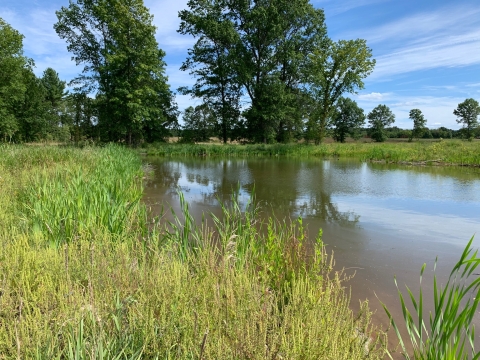
The 19-acre Hatfield Unit is located in Hatfield, MA, between Cronin Hill Road and Great Pond. The unit includes a portion of the Connecticut River floodplain and forested upland approximately 150 to 200 feet above the floodplain. There is no developed access point at this time.
The western third of the unit, along Cronin Hill Road is primarily deciduous forest comprised of white ash (Fraxinus americana), red maple (Acer rubrum), beech (Fagus grandifolia), and black cherry (Prunus serotina) with some white pine (Pinus strobus). There is a steep drop east to the floodplain adjacent to Great Pond. Historically, this pond was part of the Connecticut River mainstem that was cutoff, forming an oxbow. Today this wetland complex is listed as Core Habitat and a Priority Wetland and Aquatic Core by the Massachusetts Natural Heritage and Endangered Species Program.
Birds
Wood duck, mallard, alder flycatcher, swamp sparrow, downy and hairy woodpecker, and the tufted titmouse.
Amphibians
Northern leopard frog.
Mammals
White-tailed deer.
Dead Branch Division
The Dead Branch Division currently consists of 98 acres in the Town of Chesterfield, Massachusetts, formerly owned by Berkshire Hardwoods. The property slopes east to west with the Dead Branch River forming the current western boundary. This division is primarily northern hardwood forest, with about 10 to 15 acres containing buildings, access roads, and landings from the former sawmill. A small one- to two-acre gravel pit has been reclaimed and now provides grass/forb habitat, along with small areas on the north side of East Street that were mowed by the previous landowner. This division is open to the public for hunting, fishing, wildlife observation, photography, environmental education, and interpretation.
Birds
Blackburnian warbler, wood thrush, Canada warbler, American woodcock, eastern wild turkey, and ruffed grouse.
Mammals
White-tailed deer, black bear.
Mussels
Eastern elliptio, eastern floater.
Fannie Stebbins Unit
Beginning more than fifty years ago, members of the Allen Bird Club worked to acquire approximately 362 acres of land between Interstate 91 and the Connecticut River in Longmeadow, Massachusetts. This property became the Fannie Stebbins Memorial Wildlife Refuge. The Stebbins property and the larger floodplain area known as the "Longmeadow Flats" had been designated as a National Landmark by the U.S. Department of the Interior and an Important Bird Area by the Massachusetts Audubon Society.
The area is subject to periodic flooding that is representative of this habitat. It includes bordering swamps, ponded water, vegetated wetlands, meadows, hardwood forest and riverbank. It encompasses one of the largest remaining patches of floodplain forests and wetlands along this heavily human-impacted section of the Connecticut River. The wetlands provide breeding habitat for marsh birds and stop-over habitat for migratory waterfowl.
The Unit is open to the public from sun-up to sun-down, year round. The Unit is open to the public for wildlife observation and photography, environmental education and interpretation, and fishing, according to State regulations. The Fannie Stebbins Unit is not open for hunting.