Written By

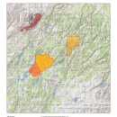
The U.S. Fish & Wildlife staff at Turnbull National Wildlife Refuge is preparing for controlled burning. These burns are implemented to reduce hazardous fuel levels on the refuge as well as to enhance and restore wildlife habitat. The map below depicts the locations of proposed burning on the Refuge. We will begin controlled burning when the fuel and weather conditions allow us to meet burn objectives safely. Some controlled burning may be added, broken up into smaller units, or delayed for another year.
Burning is planned for some time between March through May, depending on weather conditions. Burning will occur only when weather conditions are favorable and on days when smoke will disperse into the predominant air flow. Controlled burns will be conducted in accordance with regional air quality guidelines and WA-DNR permitting procedures.
These prescribed fires will reduce the risk of wildfire on the refuge and help restore native habitat. Smoke may be visible during the prescribed burns; the refuge will provide community updates on its website when a prescribed burn prescribed burn
A prescribed burn is the controlled use of fire to restore wildlife habitat, reduce wildfire risk, or achieve other habitat management goals. We have been using prescribed burn techniques to improve species habitat since the 1930s.
Learn more about prescribed burn is taking place. Prescribed burn operations represent many months and sometimes years of planning and preparation. On the refuge, prescribed burning takes place after tree thinning and piling to manage vegetation that could fuel future wildfires. This is an important part of the refuge’s habitat management planning and has occurred on the refuge for many years. Scientific evidence over the last several decades has illustrated the beneficial role low-intensity fires play in fire-dependent forests like those on the refuge. Prescribed fire, when used strategically and repeatedly, helps sustain healthy ecosystems, reduces the risk of catastrophic wildfires, and reduces the severity of future wildfires when they do occur, which can help keep communities and firefighters safer.
Two of the planned burned units abut Cheney-Plaza Rd, and one encompasses Depot Springs Rd. Commuters should keep an eye out for prescribed burn signs, fire personnel on roadway, and smoke. Drivers are encouraged to slow down near burn operations but continue moving with traffic so as to avoid traffic stoppages and clogs. Be aware of any temporary traffic control features in use in prescribed fire areas. “Safety is the number one priority during a prescribed burn,” said Project Leader Kelly Moroney. “We will work with federal, state, and county agencies and departments to complete these prescribed fire projects throughout the next several months.”
Burn Units
Unit Name | Acres | Township, Range, Section |
| Rocky Pine hand piles | ~550 | T23NR42W S21,S28 |
| Lower Turnbull | ~1,170 | T22NR41W S1 |
| Reeves landing piles | ~400 | T23NR41W S36 T23NR42W S31 |
Questions?
For questions please reach out to Refuge management via the Turnbull headquarters line: 509-235-4723 or the Complex Manager at: 509-559-3020.