

To reduce potential safety hazards associated with heat related illnesses or injuries, the Refuge is implementing temporary hiking restrictions beginning Wednesday, July 1, 2026, until further notice.
1. Hiking is permitted from sunrise until 10 a.m. ONLY.
2. All hikers on trails and the Mt. Scott Roadway must exit by 10 a.m.
3. After 10 a.m. daily, the Refuge will be closed to all hiking.
Refuge roads will remain open to motorized vehicles and bicycles. Doris Campground, fishing and picnicking will continue during normal operating hours, but backcountry camping will not be allowed. The Visitor Center (located near the intersection of Highway 49 and Highway 115) is open from 9 a.m. to 5 p.m. daily and can provide alternative suggestions to hiking or camping.
A few safety tips to remember - bring plenty of water, wear loose-fitting clothing that is light in color, wear a cap or hat, and limit the amount of time you spend outdoors in extreme temperatures. Visitors who experience an emergency or need medical assistance should contact 911 and remain in place for emergency responder. For updates check back here, our Facebook, or contact the Visitor Center at 580-429-3222.
Visit Us
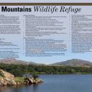
National wildlife refuges offer us all a chance to unplug from the stresses of daily life and reconnect with our natural surroundings.
Best known for its roaming herds of bison, longhorn, and Rocky Mountain elk, Wichita Mountains also offers quality opportunities for wildlife dependent recreation including fishing, bird watching, wildlife photography, hiking, camping, and kayaking. Take time to explore the roughly 29,000 acres of mixed grass prairie, ancient granite mountains, and fresh water lakes and streams.
Driving Directions
From I-44, take Highway 49 (exit 45). Go west 7 miles to the Refuge gate or 14 miles to the Visitor Center. If coming from Highway 62, take Highway 115 (Cache exit) north to the Refuge Gate. You will find leaflet dispensers inside each of the Refuge gates that have maps and information. Contact the refuge Visitor Center for more information. The coordinates for the refuge visitor center is 34.710644 and -98.623426.
Fees
There is no charge to visit the refuge, but there is a fee for camping, which can be booked online using Recreation.gov.
If you are looking for the America the Beautiful (Federal Recreational Lands) Passes, they can be purchased on Recreation.gov or at the visitor center (dependent on staff availability, appointment recommended).
Doris Campground (Modern Facility via Recreation.gov)
- Standard non-electric site: ~$14/night
- Electric hookup site: ~$22 - $24/night
- Walk‑in tent site: ~$12/night
- Group Site w/shelter (electric): ~$40/night
- Group Site non-electric: ~$40/night
- Reservation processing fee: ~$8 per booking
Charon’s Garden Wilderness (Backcountry Permits)
- Administrative permit fee: $10
- Per-person fee: $5
Fawn Creek Youth Campground (Primitive Group Site)- Designated Youth Groups ONLY
- Recreation use fee: $30 per night (tent‑only, non‑electric site)
- Reservation processing fees: $8
Restrooms
Restrooms are available at the Visitor Center, the Environmental Education Center, and at Holy City of the Wichitas. Comfort stations are available at Lake Elmer Thomas, the Mount Scott Picnic Area, Lost Lake Picnic Area, Boulder Cabin, Boulder Picnic Area, and Sunset Picnic Area.
Points of Interest
Staff and volunteers would love to help you plan your visit. Stop by the Visitor Center to become more familiar with the refuge and the wildlife that live here. Take time to explore the exhibits and watch the 15 minute refuge video. You can also pick up a refuge map to help navigate your way. While you’re there, visit the Friends of the Wichitas Nature Store for field guides, gear, and other educational items.
What to Do
If you have 2 hours to visit:
- Drive – Mount Scott Road
- Learn – Wichita Mountains Wildlife Refuge Visitors Center
- Walk – Jed Johnson Tower, Elmer Thomas Accessible Trail
- Hike – Little Baldy Trail, Osage Lake Trail, Burford Lake Trail
- Fish – Lake Elmer Thomas, Quanah Parker Lake
If you have 4 hours to visit:
- Drive – Mount Scott Road
- Learn – Wichita Mountains Wildlife Refuge Visitors Center
- Walk – Jed Johnson Tower, Elmer Thomas Accessible Trail
- Hike – Elk Trail, Longhorn Trail, Kite Trail, Narrows Trail
- Fish & Kayak – Jed Johnson Lake, Lake Elmer Thomas, Rush Lake, Quanah Parker Lake, French Lake
If you have a full day to visit:
- Drive – Mount Scott Road
- Learn – Wichita Mountains Wildlife Refuge Visitors Center
- Hike – Bison Trail
- Hike & Bike – Mount Scott Service Road
- Fish & Kayak – Jed Johnson Lake, Lake Elmer Thomas, Rush Lake, Quanah Parker Lake, French Lake
Know Before You Go
- Bring water with you. The refuge has no potable water available for drinking.
- Bring more water than you think you need. Take it with you on the trail. Warm weather can quickly cause heat exhaustion. Visitors should have water with them at all times.
- Cell phone coverage is spotty across the refuge. You may not be able to call out if you need assistance. Take a map and go prepared.
- Bison and longhorn are free roaming. For your safety and theirs, do not approach them.
- All camping is by reservation only through Recreation.gov.
- If hiking alone, let someone know your plans.
- Practice LEAVE NO TRACE
Visitor Tips
The refuge is open from sunrise to sunset daily. Animals are most active in the early morning and late evening. Weekends are overwhelmingly busy at times. Try to schedule your visit Monday through Thursday if you are looking to explore without the crowds. Maps of the refuge are available at the pull outs near each entry gate. Volunteers and staff are available at the Visitor Center and can help guide your visit and provide more information about the refuge should you need it.
Activities
Find your wild in the wide open spaces of the Wichita Mountains. Whether you like to hike, fish, or photograph, Wichita Mountains Wildlife Refuge has plenty of wildlife dependent recreational opportunities.
Trails
Jed Johnson Tower Trail
Open Season: Open year-round
Length: 0.5 mile
Location of trail: Jed Johnson Lake Parking Area
Surface : Dirt, Gravel, Rock
Difficulty: Easy
This easy half-mile (0.5 mile), kid friendly hike follows portions of the shoreline of Jed Johnson Lake offering spectacular views of the lake and the surrounding landscape from the base of the Civilian Conservation Corps built observation tower. The observation tower is not open to public.
Environmental Education Center Trail
Open Season: Open year-round
Length: 0.1 mile
Location of trail: Environmental Education Center Parking Area
Surface : Paved
Difficulty: Easy
This short (0.1 mile), but fully accessible trail tours the grounds around the Environmental Education Center and Quanah Parker Lake.
Quanah Parker Lake Trail
Open Season: Open year-round
Length: 0.4 mile
Location of trail: Environmental Education Center Parking Area, Doris Campground
Surface: Gravel, Dirt
Difficulty: Easy
Take a quick (0.4 mile) stroll across Quanah Parker Lake via bridge and through the trees along the shore using this trail linking Doris Campground to the Environmental Education Center, or vice versa. ***Visitors not camping in Doris Campground should not enter the campgrounds.***
Little Baldy Trail
Open Season: Open year-round
Length: 0.8 mile
Location of trail: Quanah Parker Dam
Surface: Gravel, Rock, Dirt
Difficulty: Moderate
Gain some elevation and test yourself by tackling the Little Baldy Trail (0.8 mile). Scramble to the top of this mountain for a beautiful view of Quanah Parker Lake and the surrounding peaks.
Osage Lake
Open Season: Open year-round
Length: 0.6 mile
Location of trail: Osage Lake Parking Area
Surface: Gravel, Dirt, Rock
Difficulty: Easy
Fishing and hiking aren’t always mutually exclusive. This quick track (0.6 mile) will land you on the shore of Osage Lake and a prime spot for bluegill and crappie fishing.
Burford Lake Trail
Open Season: Open year-round
Length: 0.5 mile
Location of trail: Burford Lake Parking Area
Surface : Dirt, Gravel, Rock
Difficulty: Easy
Nature is only a few steps away from the parking lot along the Burford Lake Trail. Skirting the edges of Burford Lake, this trail offers informational waysides and opportunities to experience the varied landscape (i.e. prairie, lake, forest, rocks).
Narrows Trail
Open Season: Open year-round
Length: 0.8 mile
Location of trail: Boulder Cabin Picnic Area
Surface : Loose Gravel, Rocks
Difficulty: Moderate
If you’re up for a bit of a challenge, the Narrows Trail (0.8 mile) offers stunning views and, depending on the season, fun obstacles like a stream crossing.
Kite Trail
Open Season: Open year-round
Length: 1.1 mile
Location of trail: Lost Lake or south Boulder Picnic Area
Surface : Gravel, Dirt, Rock
Difficulty: Moderate
If you’re looking for a hike with scenery, the Kite Trail (1.1 mile) meanders along a canyon rim with breathtaking views of Forty Foot Hole.
Bison Trail, Dog Run Hollow Trail System
Open Season: Open year-round
Length: 1.5 mile
Location of trail: French Lake Parking Area, Dog Run Hollow Trailhead
Surface: Dirt, Rock, Gravel
Difficulty: Moderate
Go the distance on the Bison Trail. This lengthy (6 mile) trail is perfect for leisurely strolls near the shore of French Lake, alongside Cache Creek, and through the mixed grass prairie. Hikers should bring plenty of water, especially during the warm months, as this trail has very little shade.
Longhorn Trail, Dog Run Hollow Trail System
Open Season: Open year-round
Length: 1.5 mile
Location of trail: French Lake Parking Area,
Surface: Dirt, Rock, Gravel
Difficulty: Easy
Similar to the Elk Trail, the Longhorn Trail (1.5 miles) joins the Bison Trail creating a shorter loop to explore the prairie. Stretch your legs on the Longhorn, or really push yourself by completing the entire Dog Run Hollow System.
Elk Trail, Dog Run Hollow Trail System
Open Season: Open year-round
Length: 0.7 mile
Location of trail: French Lake Parking Area
Surface: Dirt, Rock, Gravel
Difficulty: Easy
This short stretch (0.7 mile) connects to the Bison Trail providing an easy but shorter loop to look for wildlife or stroll along the shore of French Lake.
Lake Elmer Thomas Trail
Open Season: Open year-round
Length: 1 mile
Location of trail: Lake Elmer Thomas Parking Areas
Surface: Paved
Difficulty: Easy
Perfect for wheelchairs, bicycles, strollers, etc., this fully accessible, paved 1 mile trail wanders past the historic Wichita Mountains gate and provides glimpses of Lake Elmer Thomas.
Elk Mountain Trail
Open Season: Open year-round
Length: 1.1 Miles
Location of trail: Sunset Picnic Area
Surface: Rock, Dirt, Gravel
Difficulty: Difficult
Located in the Charon’s Garden Wilderness Area, the Elk Mountain Trail is a rocky route with seemingly endless stone stairs. It requires plenty of water, a map, and some preparation.
Charon’s Garden Trail
Open Season: Open year-round
Length: 2.4 miles
Location of trail: Sunset Picnic Area, Treasure Lake Parking Area
Surface: Dirt, Rock, Gravel
Difficulty: Difficult
This trail isn’t for the faint of heart. This 2.4 mile trek begins at the Sunset trailhead and stretches across the Charon’s Garden Wilderness Area to Treasure Lake. If you plan to hike through make sure you are fully prepared, have plenty of water, and a pick up planned.
Related Documents


Rules and Policies
Hiking and Picnicking
- Hiking and picnicking are limited to daylight hours.
- Group size limitations are listed as follows:
- 8 people or less on the Mt. Scott Roadway (when open).
- 15 people or less in the Charon’s Garden Wilderness Area.
- 30 people or less in Dog Run Hollow/Lost Lake/Boulder area
- There is no group size limit east of SH 115 except for the Mt. Scott Roadway.
Camping
- Camping is allowed only in designated areas and by reservation only via Recreation.gov.
- Fires are allowed only in provided fire rings and grills of picnic/camping areas.
- Fires must be attended at all times and completely extinguished before leaving.
- Dead, downed wood may be gathered (no saws) for use only in designated areas.
- Dispose of trash in appropriate receptacles; littering is prohibited.
Fishing and Boating
- Fishing is permitted in accordance with state and federal regulations on all refuge lakes and streams in the public use area (see map).
- Fish may be taken only with poles and lines or rods and reels.
- Anglers may use tube-type floaters, life jackets, or buoyant vests.
- Wading is permitted when fishing; swimming and snorkeling are prohibited.
- Taking bait, frogs, or turtles from the refuge is prohibited.
- Fishing piers are available near the Environmental Education Center and Lake Elmer Thomas.
- Non-motorized boats, paddleboards, and boats less than 14’ with electric trolling motors are permitted only on Jed Johnson, Rush, Quanah Parker, and French Lakes.
- Operators of motorized boats must use designated boat ramps.
- Motorized boats and sailboats are permitted on Lake Elmer Thomas, but there is a no-wake rule across the entire surface of the lake.
- No fishing from roadway bridges.
General Regulations
- Observe posted speed limits, signs, and state traffic laws.
- Motorized vehicles are allowed only on paved roads and parking areas, and in hardened, dirt pullouts and parking lots.
- Parking on the grass is prohibited; violators may be towed.
- Parking in the roadway or obstructing traffic is prohibited.
- Unless fishing, all parking areas, pullouts, refuge side roads, and trailheads close sunset to sunrise. Main roads remain open for travel at any time; thru traffic only.
- Nighttime activities other than fishing are prohibited without a special use permit.
- Pets must be under direct control on a leash less than 10 feet long at all times.
- Pets must be provided sufficient resources, care and protection from the environment to maintain their health when visiting the refuge. Do not leave pets unattended in vehicles or abandon pets on the refuge.
- The use of horses and other domesticated livestock on the refuge is prohibited.
- Bicycles are allowed only on paved roads, the Mt. Scott Service Road, the Lake Elmer Thomas Service Road, and the LETRA Trail.
- Alcoholic beverages, drugs, and drug paraphernalia are prohibited.
- Fireworks are prohibited.
- ATV’s, UTVs and Golf Carts are prohibited.
- Drones, remote controlled aircraft, and unmanned aerial vehicles are prohibited.
- Using skates, skateboards, longboards, luge boards, and other similar devices is prohibited.
- The installation, replacement, or removal of climbing anchors/bolts is prohibited.
- Rock sports are allowed throughout the Public Use Area during daylights hours, with the notable exception of a prohibition against rappelling in the Narrows.
- All caves, sinkholes, tunnels, and mines are closed to access to prevent the spread of White-nose syndrome.
- The operation or use of audio devices including radios or other noise devices, so as to cause disturbance of wildlife or unreasonable disturbance to others in the vicinity, is prohibited.
- Collection of plants, rocks, animals, minerals, bones, and antlers is prohibited.
- Use of metal detectors or any activities that involve searching for, collecting or disturbing artifacts or treasures is prohibited.
- Special Use Permits are required for all special events and commercial activities, including but not limited to: nighttime activities, guided tours, filming, commercial photography, scuba diving instruction, fishing tournaments, and rock climbing classes.
- Persons possessing, transporting, or carrying firearms on national wildlife refuges must comply with all provisions of state and local laws. Persons may only use (discharge) firearms in accordance with refuge regulations (50 CFR 27.42 and specific refuge regulations in 50 CFR Part 32).
- Individuals that participate in hunting and fishing activities or who have a special use permit for collection on the refuge are subject to inspection of all harvested resources, licenses, permits, vehicles, containers, packs, bags etc., that are used in support of these permitted activities.
- Hunting is permitted only in accordance with state and refuge regulations as listed in the Hunting Tear Sheet.
Locations
From I-44, take Highway 49 (exit 45). Go west 7 miles to the Refuge gate or 14 miles to the Visitor Center. If coming from Highway 62, take Highway 115 (Cache exit) north to the Refuge Gate. You will find leaflet dispensers inside each of the Refuge gates that have maps and information. Contact the refuge Visitor Center for more information. The coordinates for the refuge visitor center is 34.710644 and -98.623426.