

Visit Us
National wildlife refuges offer us all a chance to unplug from the stresses of daily life and reconnect with our natural surroundings. Roanoke River NWR is made up of various tracts of land - some of which are accessible only by boat via the Roanoke River (Great & Goodman Islands, Broadneck Swamp, Hampton Swamp, and Company Swamp). Depending on the season, location, and river water levels, the bottomland hardwood forests may be dry or inundated in several feet of water. Visitors can enjoy wildlife viewing and photography, hiking, hunting, fishing, and boating.
Activities
Hunting, fishing, boating, birding, and hiking are the most popular activities on Roanoke River NWR. The refuge is open seven days a week from sunup to sundown except during permitted hunt days. On permitted hunt days the Refuge is closed to all without a valid permit.
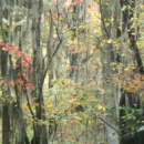
The Refuge has one designated Hiking Trail, the Kuralt Trail, which is a little over 1 mile long round-trip. It is located off of Hwy 13/17N. There are two maintained roads along Hwy 13/17 that are also available for walking.
You will need to bring sturdy shoes/boots as the walking is on rough terrain and frequently floods. During spring/summer, mosquitos, black flies, ticks, and snakes may be encountered. Dawn and dusk are optimal wildlife viewing times.
Trails
The refuge maintains one trail and several roads in units accessible by land, offering a bounty of wildlife viewing and photography opportunities. The Kuralt Trail is a 0.65 mile one-way gravel-surface trail; in addition, the dirt Conine North and Askew East and West roads on either side of Highway 13/17 are open for hiking and walking. There are no designated parking areas on the dirt roads. Park in a way that does not block the gate.
Note that the refuge is subject to closure for managed hunts during certain times of the year. Contact the refuge headquarters for hunt dates and closure information. Refuge trails and roads occasionally flood. Bring appropriate footwear and clothing for muddy conditions. Roads and trails may be impassable at times.
Related Documents

Other Facilities in the Complex
The refuge is managed as part of the Coastal North Carolina National Wildlife Refuge Complex. A National Wildlife Refuge Complex is an administrative grouping of two or more refuges, wildlife management areas or other refuge conservation areas that are primarily managed from a central office location. Refuges are grouped into a complex structure because they occur in a similar ecological region, such as a watershed or specific habitat type, and have a related purpose and management needs.
There are 9 national wildlife refuges in the Coastal North Carolina National Wildlife Refuges Complex. The Project Leader for the Complex supervises the Refuge Managers who are responsible for managing these refuges. However, there are five distinct and separate administrative offices. Alligator River and Pea Island National Wildlife Refuges are administered from the Alligator River National Wildlife Refuge Headquarters in Manteo, NC. An administrative office at the Mackay Island National Wildlife Refuge Headquarters in Knotts Island, NC manages both Mackay Island and Currituck National Wildlife Refuges. An office at Mattamuskeet National Wildlife Refuge administers Mattamuskeet, Swanquarter, and Cedar Island National Wildlife Refuges. Pocosin Lakes National Wildlife Refuge, Roanoke River National Wildlife Refuge, Great Dismal Swamp National Wildlife Refuge, Back Bay National Wildlife Refuge, and Edenton National Fish Hatchery each have separate administrative offices.
All of the Coastal North Carolina National Wildlife Refuges, Great Dismal Swamp National Wildlife Refuge, Back Bay National Wildlife Refuge, and Edenton National Fish Hatchery are open to public visits for nature-based recreational enjoyment. Priority public uses are hunting, fishing, wildlife observation, wildlife photography, environmental education, and interpretation.


Locations
The Refuge itself is made up of various tracts of land. Contact the office for directions to the different locations.
Refuge Headquarters:
From Williamston – Take US Hwy 13/17 N, then turn right onto US Hwy 17 Business N. In approximately one mile, you will turn right into the Headquarters Office driveway. There is a wooden farmer's market building in front of ours and a Refuge sign next to the driveway. Follow the driveway to our parking area in the front of the building.
From Edenton – From the HWY 17 S Bypass, turn left onto Business HWY 17/South King Street. Continue until you reach the stoplight. Turn left onto Business 17; in a couple blocks you will turn left into the Headquarters Office driveway. There is a wooden farmer's market building in front of ours and a Refuge sign next to the driveway. Follow the driveway to our parking area in the front of the building.
From Ahoskie – Take US Hwy 13 S. into Windsor on King Street. Turn right (at the 2nd Stoplight) onto Bus 17. In a couple of blocks you will turn left into the Headquarters Office driveway. There is a wooden farmer's market building in front of ours and a Refuge sign next to the driveway. Follow the driveway to our parking area in the front of the building.
The Kuralt Walking Trail is approximately over 1.3mi round-trip (out and back).
The trailhead is located on our Conine Island Tract off US Hwy 13/17 N just past the Roanoke River Bridge outside of Williamston. Traveling US Hwy 13/17 S you would need to cross the bridge, turn around, and come back as there is no access to the trail from that side of the road.