


Visit Us
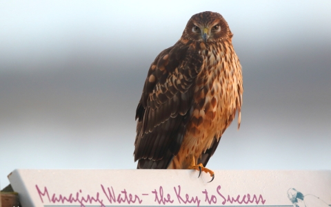
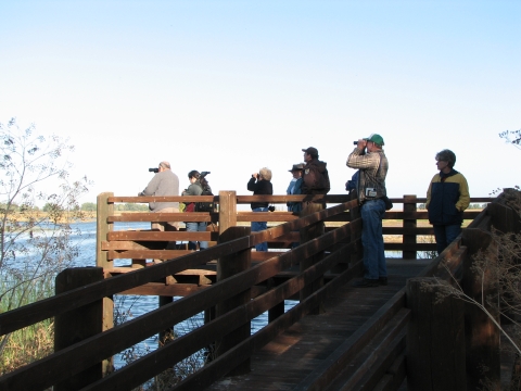
National wildlife refuges offer us all a chance to unplug from the stresses of daily life and reconnect with our natural surroundings. The refuge offers visitors a 5-mile auto tour route and 4 nature trails to observe and photograph wildlife. These features allow visitors to get close to the sights and sounds of the diverse wildlife species that live here. Birds, mammals, reptiles, amphibians, fish, insects, and native plants – they are all here and chances are our auto tour route and nature trails will allow you to see or hear many of them.
Conditions change from season to season in these habitats, so the species you might see will also change. While many bird species are year-round residents, most birds are seasonal and can only be observed during specific times of the year. Other bird species pass through for a few short weeks during fall or spring migration. Just as the birds change with the seasons, so do the landscapes. Early spring wildflowers give way to summer grasses, and even certain insect species you may not have noticed in the spring become very apparent in the fall such as various dragonfly species. During the hot dry days of summer, you are more likely to see a greater number of bird species in the morning – the next best time for summer birds is in the late afternoon/early evening. Likewise, most mammals are more likely to be visible in the morning or early evening during the hot months.
There is always something to see at the refuge, but certain times are better than others and the cast of nature’s characters changes with the seasons. The spectacular concentrations of waterfowl and sandhill cranes occur during autumn through spring. No matter when you visit, bring your binoculars, camera – and your curiosity! There is no fee to visit the auto tour routes and nature trails.
Tips for an enjoyable visit
Dress appropriately for the seasons. Comfortable walking shoes are recommended for nature trails. Summer months can reach extreme temperatures of over 100 degrees for weeks at a time. Always bring and carry plenty of water. Hats and sunscreen are highly recommended. Mosquitoes can be very active, especially during fall and spring. Mosquito repellant is recommended. Binoculars and a camera will help you get the most of your visit.
During the hot dry days of summer, you are more likely to see a greater number of bird species in the morning – the next best time for summer birds is in the late afternoon/early evening. Likewise, most mammals, including the tule elk, are more likely to be visible in the morning or early evening during the hot months.
If you have 15-minutes: Enjoy a relaxing stroll on the Cottonwood trail located on the north side of Sandy Mush Road.
If you have one hour: Travel the auto tour route and explore the Bittern Marsh trail or Meadowlark trail.
If you have half a day or more: Travel the auto route route and explore all 4 of the refuge’s nature trails. Bring a picnic lunch to eat under the picnic shelter near the entrance information kiosk.
Activities
National wildlife refuges offer us a chance to unplug from the stresses of daily life and reconnect with our natural surroundings. The refuge offers visitors a 5-mile auto tour route and 4 nature trails to observe and photograph wildlife. There is always something to see at the refuges, but certain times are better than others and the cast of nature’s characters changes with the seasons. No matter when you visit, bring your binoculars, camera – and your curiosity!
Trails
The refuge features 4 nature trails for wildlife observation and photography. Nature trails are open to foot traffic only. Please stay on trails, except at special areas where leaving the trail is allowed and indicated by signage. Dogs are allowed on nature trails, but must be on a leash and under control at all times. The Cottonwood trail is open for visitors, but not included in the list below. Please read our HIKING page for descriptions of each trail.
Related Documents
The Auto Tour and Nature Trail brochure features maps and information about the refuge auto tour route and trails. Visit the "Library" page to download all of our brochures, including bird and mammal lists.

Other Facilities in the Complex
The Merced NWR is part of the San Luis NWR Complex. A national wildlife refuge national wildlife refuge
A national wildlife refuge is typically a contiguous area of land and water managed by the U.S. Fish and Wildlife Service for the conservation and, where appropriate, restoration of fish, wildlife and plant resources and their habitats for the benefit of present and future generations of Americans.
Learn more about national wildlife refuge complex is an administrative grouping of two or more refuges, wildlife management areas or other refuge conservation areas that are primarily managed from a central office location. Refuges are grouped into a complex structure because they occur in a similar ecological region, such as a watershed or specific habitat type, and have a related purpose and management needs. Typically, a project leader or complex manager oversees the general management of all refuges within the complex and refuge managers are responsible for operations at specific refuges. Supporting staff, composed of administrative, law enforcement, refuge manager, biological, fire, visitor services, and maintenance professionals, are centrally located and support all refuges within the complex.
Other units in the San Luis NWR Complex include the San Luis NWR, San Joaquin River NWR, and Grasslands Wildlife Management Area.


Locations
This is the main refuge entrance and the location to access the auto tour route and the Meadowlark, Kestrel, and Bittern Marsh trails. The auto tour route and trails are open daily year-round from 1/2-hour before sunrise to 1/2-hour after sunset.
From Los Banos: Travel east on Pacheco Blvd to Mercey Springs Road. Turn left on Mercey Springs Road. Continue on Mercey Springs Road for approximately 3 miles to Henry Miller Road. Turn right on Henry Miller Road and continue for approximately 7 miles to Turner Island Road (4-way stop). Turn left on Turner Island Road. After approximately 5.25 miles, turn right onto Sand Slough Road. Sand Slough Road will curve to the left and become Nickel Road. After approximately 1 mile, the road makes a sharp right and becomes Sandy Mush Road. Continue on Sandy Mush Road for approximately 3.5 miles to the refuge entrance on the right (south) side of the road.
From CA-99: Take the CA-152 west exit and travel westbound on CA-152 for approximately 15 miles. Take the CA-59 north exit toward Merced and travel north for approximately 7 miles to Sandy Mush Road. Turn left on Sandy Mush Road and travel westbound for approximately 8 miles to the refuge entrance on the left (south) side of the road.
From Interstate 5: Take the Los Banos/CA-152 east exit. Travel on CA-152 eastbound into Los Banos. Turn left on Mercey Springs Road. Continue on Mercey Springs Road for approximately 3 miles to Henry Miller Road. Turn right on Henry Miller Road and continue for approximately 7 miles to Turner Island Road (4-way stop). Turn left on Turner Island Road. After approximately 5.25 miles, turn right onto Sand Slough Road. Sand Slough Road will curve to the left and become Nickel Road. After approximately1 mile, the road makes a sharp right and becomes Sandy Mush Road. Continue on Sandy Mush Road for approximately 3.5 miles to the refuge entrance on the right (south) side of the road.
This is the entrance and parking lot for the Cottonwood trail. The trail is open daily during fall through spring from 1/2-hour before sunrise to 1/2-hour after sunset. Foot traffic only is allowed.
From Los Banos: Travel east on Pacheco Blvd to Mercey Springs Road. Turn left on Mercey Springs Road. Continue on Mercey Springs Road for approximately 3 miles to Henry Miller Road. Turn right on Henry Miller Road and continue for approximately 7 miles to Turner Island Road (4-way stop). Turn left on Turner Island Road. After approximately 5.25 miles, turn right onto Sand Slough Road. Sand Slough Road will curve to the left and become Nickel Road. After approximately 1 mile, the road makes a sharp right and becomes Sandy Mush Road. Continue on Sandy Mush Road for approximately 4.75 miles to the trail parking lot on the left (north) side of the road. You will drive past the main refuge entrance before reaching the trail parking lot.
From CA-99: Take the CA-152 west exit and travel westbound on CA-152 for approximately 15 miles. Take the CA-59 north exit toward Merced and travel north for approximately 7 miles to Sandy Mush Road. Turn left on Sandy Mush Road and travel westbound for approximately 6.75 miles to the trail parking lot on the right (north) side of the road.
From Interstate 5: Take the Los Banos/CA-152 east exit. Travel on CA-152 eastbound into Los Banos. Turn left on Mercey Springs Road. Continue on Mercey Springs Road for approximately 3 miles to Henry Miller Road. Turn right on Henry Miller Road and continue for approximately 7 miles to Turner Island Road (4-way stop). Turn left on Turner Island Road. After approximately 5.25 miles, turn right onto Sand Slough Road. Sand Slough Road will curve to the left and become Nickel Road. After approximately1 mile, the road makes a sharp right and becomes Sandy Mush Road. Continue on Sandy Mush Road for approximately 4.75 miles to the trail parking lot on the left (north) side of the road. You will drive past the main refuge entrance before reaching the trail parking lot.