


Visit Us
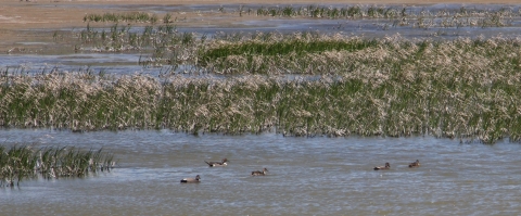
Lake Mason National Wildlife Refuge is one of four satellite National Wildlife Refuges in central Montana managed by the Charles M. Russell National Wildlife Refuge Complex and that resides within the Charles M. Russell Wetland Management District. It consists of three separate tracts of land: Lake Unit, Willow Creek Unit, and North Unit. Information on these units can be found in the "About Us" page. With the exception of the north half of the Lake Unit, which has been designated as permanent refugia for wildlife and thus closed to all public entry, the Refuge is open to hunting, wildlife observation, and photography. In addition to compliance with all applicable State hunting regulations, non-toxic shot must be used to harvest waterfowl and upland game birds.
What to Bring
Binoculars, a backpack, and water are all essential items to bring any time you venture out to recreate on any public land. Additional helpful items are boots to protect your feet from prickly pear cactus, weather-appropriate gear, and bug repellant for the seasonally plentiful mosquitoes found on the Refuge units.
General Travel
As with traveling in any remote area, please keep emergency supplies, a full spare tire, and an eye out for changing weather or roads conditions in order to stay safe while enjoying these places. No off-road mechanized travel is permitted and is prohibited by federal law. Please stay on established routes and roads.
Activities
Activities on Lake Mason National Wildlife Refuge range from wildlife viewing, to hunting permitted species in season, to landscape and wildlife photography.
Please see the "Rules and Policies" section of this page for more information.
Related Documents
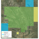
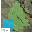
Georeferenced satellite imagery maps showing each unit of Lake Mason National Wildlife Refuge.


Other Facilities in the Complex
Residing within the boundaries of the Charles M. Russell Wetland Management District, this Refuge is managed as part of the Charles M. Russell National Wildlife Refuge Complex. A National Wildlife Refuge Complex is an administrative grouping of two or more Refuges, wildlife management areas, or other Refuge conservation areas that are primarily managed from a central office location. Refuges are grouped into a complex structure because they occur in a similar ecological region, such as a watershed or specific habitat type, and have a related purpose and management needs. Typically, a project leader or complex manager oversees the general management of all Refuges within the complex and Refuge managers are responsible for operations at specific Refuges. Supporting staff, composed of administrative, law enforcement, Refuge management, biological, fire, visitor services, and maintenance professionals, are centrally located and support all Refuges within the complex.
The District Manager for the Charles M. Russell Wetland Management District serves as the manager for Lake Mason National Wildlife Refuge.


Rules and Policies
The regulations below apply to Lake Mason National Wildlife Refuge and all of its respective units: Lake Unit, North Unit, and Willow Creek Unit.
Locations
Lake Mason National Wildlife Refuge consists of three separate tracts of land: Lake Mason Unit, Willow Creek Unit, and North Unit.
To access the 13,589-acre Lake Mason Unit, turn south from Highway 87 on 4th Street West in Roundup. Proceed 1 block and turn west on the Golf Course Road. Continue for 6.5 miles, then turn north and proceed 2 miles to the refuge boundary.
The 2,240-acre Willow Creek Unit is 22 miles northwest of Roundup, Montana. To access the Willow Creek Unit, proceed 11 miles north of Roundup on Highway 87. Turn west on Snowy Mountain Road (also Forest Service access to the Little Snowy Mountains), and drive 13.8 miles to the unit.
The 5,323-acre North Unit is located 24-miles northwest of Roundup, Montana. For access to the North Unit, drive north of Roundup 11 miles on Highway 87, and turn west on the Snowy Mountain Road (also Forest Service access to the Little Snowy Mountains). After 7 miles, turn north on the Graves Road and continue 7.3 miles, then turn west again on a small, two-track trail. The refuge lies 2.2 miles west of the Graves Road.