

Visit Us
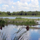
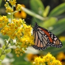
National wildlife refuges offer us all a chance to unplug from the stresses of daily life and reconnect with our natural surroundings. Green Bay National Wildlife Refuge contains ecotypes and habitat rare elsewhere in Wisconsin, including the coastal fens and alvars (e.g. limestone barrens). These communities support rare plants such as dwarf lake iris (Iris lacustris) and Canada yew (Taxus canadensis). With Lake Michigan as the backdrop, there are many opportunities to explore these rare communities, see unique wildlife species and take in views of historic lighthouses and shipwrecks.
Driving Directions
- The refuge can be accessed only via private boat, kayak or by contacting permitted commercial charter companies (Friends of Plum and Pilot Islands, and Death's Door Boat Tours).
- Plum Island coordinates: 85 56' 52.073"W 45 18' 46.55"N
- Detroit Island coordinates: The parcel is located on the west shoreline at coordinates: N 45° 18’ 17.7” W 086° 54’ 11.6”
Fees
There is no charge to visit the refuge.
Restrooms
A dual stall concrete vault toilet is located behind the historic crew's quarters building.
Points of Interest
- Plum Island trails
- Plum Island historic Coast Guard structures including lighthouse
- Grapeshot shipwreck
- Pilot Island Lighthouse
What To Do
If you have half a day or more
- Visit Plum Island to hike the trails to see unique plant communities and view historic Coast Guard structures including the last remaining “Duluth-style” life-saving station in the Great Lakes. You may also view the Grapeshot shipwreck via boat or snorkel.
Know Before You Go
- Access to islands can be limited by weather and lake conditions
- Plum Island is open the Friday before Memorial Day through Labor Day annually, and is only open for daylight use. Overnight docking is not allowed.
- Plum Island can only be reached by private boat or by authorized commercial operators. Commercial operators are provided docking space, but private boats must dock on the outside of the east pier dock. Follow signs found at the east pier dock.
- Restrooms are available at the Plum Island unit; no restrooms are available at Detroit Island unit
- Drinking water is not available at either site at this time. Plan to bring your own drinking water
- Plum and Detroit island units are Leave No Trace sites. Please pack out what you pack in as there are no available trash or recycling services
- Cellular service is limited
- Pilot, Hog and Rocky Islands (Green Bay National Wildlife Refuge) and Spider and Gravel Islands (Gravel Island National Wildlife Refuge) are closed to public access for use by colonial nesting birds. Please maintain 1/4 mile distance from these islands to minimize disturbance to the birds, their nests and their young
- St. Martin Island is also closed to public access for habitat and other resource protection
Visitor Tips
- Weather and lake conditions can change rapidly. Be prepared and monitor conditions.
- Consult Door County Tourism for all opportunities available in the area
Activities
Plum Island is open Memorial Day weekend through Labor Day weekend annually for wildlife observation, nature photography, hiking and viewing of historical Coast Guard structures. Interpretive programs and events are offered seasonally by the Friends of Plum and Pilot Islands.
Trails
The only established trails for public hiking exist on Plum Island and are remnants of the historic U.S. Coast Guard trails or patrol roads. Rember to bring along water, and prepare for uneven terrain on these established but rustic trails.
Central trails (Island interior)
Fern Trail
Length: From the historic crew's quarters building, one way .5 miles, round trip 1 mile
Surface: Mowed grass and vegetation
Habitat: Northern mesic forest including maple, basswood, hackberry, birch, with some balsam fir and cedar
Perimeter Trails (Island perimeter)
Fog Signal Trail
Length: From the rear range light and historic keeper's quarters, one way .5 miles, round trip 1 mile
Surface: Mowed grass and vegetation, bare soil and rock
Habitat: Open meadow, forest of cedar and mixed hardwoods and birch, wetland community
Island View Trail
Length: From the historic crew's quarters building, 1.7 miles, including center trail as full loop 2.3 miles
Surface: Mowed grass and vegetation, bare soil
Habitat: Northern mesic forest including maple, basswood, hackberry, birch, with some balsam fir and cedar
Related Documents
Audio Tour Available - Plum and Pilot Islands: From the Boat (izi TRAVEL app)- courtesy of Friends of Plum and Pilot Islands

Other Facilities in the Complex


Rules and Policies
- Plum Island is open for hiking and wildlife observation Memorial Day weekend through Labor Day weekend. Daylight hours only. Plum Island coordinates: 85 56' 52.073"W 45 18' 46.55"N.
- Hog Island is closed to all public use to protect colonial nesting birds
- Pilot Island is closed to all public use to protect colonial nesting birds
- St. Martin Island is currently closed to all public use
- Detroit Island Unit includes 148 acres of Detroit Island open for public access including deer hunting. The remainder of the island is privately owned. The parcel is located on the west shoreline at coordinates: N 45° 18’ 17.7” W 086° 54’ 11.6”.
- Rocky Island is closed to all public use to protect colonial nesting birds
Locations
For general information email GreenBayRefuge@fws.gov