


The Idaho Department of Environmental Quality (DEQ) has evidence of a potentially toxic bloom, but the presence of toxins exceeding the human health advisory recommendations hasn't been confirmed at this time. Use caution when allowing animals in the water. Review DEQ's website for more information.

To minimize disturbance of nesting osprey, a section of the Observation Hill Trail is temporarily closed from mile marker 1.5 - 1.8 (the loop section closest to the lake.)
(Español) Para minimizar estorbo en la anidación de los águilas pescadoras, una sección del sendero Observation Hill Trail está cerrada temporalmente desde el marcador de milla 1,5 hasta el 1,8 (cerca del lago en el circuito.)
Visit Us
National wildlife refuges offer us all a chance to unplug from the stresses of daily life and reconnect with our natural surroundings. With a nearly 9,000-acre lake and more than 10 miles of trails, refuge visitors can easily find an adventure for their experience level. As you visit this wildlife home, be sure to slow down to watch wildlife and look for signs of wildlife like tracks, scat, and nests. Whether you come to fish; to boat or swim in Lake Lowell; to hike, bird, hunt, or picnic; or to watch a sunset in the nearby uplands, there are many opportunities to connect with nature during your visit.
Choose a topic to learn more about ways to have a memorable and safe experience at Deer Flat National Wildlife Refuge.
- Driving Directions
- Fees
- Hours
- Restrooms
- Points of Interest
- What To Do (If you have 15 minutes, 1 hour, half day or more)
- Know Before You Go
- Visitor Tips
- Maps
- Activities
- Trails
- Rules & Policies
Driving Directions
Driving directions to the refuge visitor center
- Take Exit 33 off of Interstate 84.
- After exiting the freeway, turn right (west) onto Highway 55/Karcher Road.
- Follow Karcher Road about 3.5 miles to Lake Avenue.
- Turn left onto Lake Avenue and drive about 2.5 miles to the intersection with Roosevelt Avenue.
- Turn right onto Roosevelt Avenue.
- At Indiana Avenue at the top of the hill, turn left into the refuge and follow the road to the visitor center
Fees
There is no charge to visit.
Hours
The Refuge is open daily during daylight hours. The Visitor Center is typically open weekdays from 8:00 a.m. to 4:00 p.m. and Saturdays from 10:00 a.m. to 4:00 p.m., except on Federal holidays. Occasionally these hours may shift if staff are in the field or volunteers are unavailable.
Restrooms
Restrooms are available inside the refuge visitor center. Vault toilets are available at the Lower Dam Recreation Area, the boat launch at the west end of the Upper Dam, and at Gotts Point. Restrooms are also available in Canyon County’s Lake Lowell Park across from the east end of the Upper Dam.
Points of Interest
Let our staff and volunteers at the refuge visitor center help you plan your visit! The visitor center is a great starting point for visitors to become more familiar with the refuge and the wildlife that live here. Browse nature and wildlife exhibits, view wildlife from the observation room, enjoy hands-on activities in the KidSpace area, borrow binoculars for some wildlife watching, and pick up a refuge brochure and map. While there, also visit the Grebe’s Nest Nature Store for water bottles, field guides, and various other educational items. Purchases support the Friends of Deer Flat.
Some other points of interest include:
- Hiking trails: Experience Deer Flat National Wildlife Refuge from different perspectives and wander through different habitats on our over 10 miles of hiking trails.
- Fishing access points: Cast a line, enjoy the breeze, listen to the waves and the wildlife and maybe even catch a fish! Popular fishing spots include the accessible fishing dock at the west end of the Upper Dam and from shore at Gotts Point or along the Upper and Lower Dams.
- Snake River Islands Unit driving tour: Take a scenic drive along the Snake River to see some of the islands in the refuge’s Snake River Islands Unit. Link
- Lower Dam Recreation Area: Visit the Lower Dam Recreation Area or the east end of the Upper Dam to enjoy picnicking, barbecues, swimming, boating and more with family and friends. This area is open annually from April 15 through September 30. If you’re planning an event, please contact deerflat@fws.gov to find out about event rules and whether you need a free special use permit.
- Viewing platform: Enjoy views of almost the entire Lake Lowell Unit from the viewing platform along the Observation Hill Trail. Hike to the platform through sagebrush sagebrush
The western United States’ sagebrush country encompasses over 175 million acres of public and private lands. The sagebrush landscape provides many benefits to our rural economies and communities, and it serves as crucial habitat for a diversity of wildlife, including the iconic greater sage-grouse and over 350 other species.
Learn more about sagebrush uplands with views of the lake and its forested edge. Or request a permit to drive to the platform.
What to do
If you have 15 minutes
- Explore the visitor center.
If you have one hour
- Explore the visitor center.
- Take a short hike on the Sagebrush Trail near the visitor center. Stop at the interpretive panels to learn about the history of the refuge and reservoir.
- Enjoy bird watching from the bird blind along the nearby Nature Trail.
- Is Fido begging you for a walk? Bring him/her along on your refuge visit to enjoy the sights, sounds - and of course smells - of nature!! Dogs must be on a leash 6 feet long or less. Pet waste must be bagged and removed. Find out about how to be a BARK Ranger!
- Paddle the lake in your canoe or kayak.
- Enjoy a sunrise or sunset from the Observation Hill or Gotts Point trails.
- Enjoy a picnic at the visitor center or the Lower Dam Recreation Area. Please remember to bring your litter home with you.
- Swimming is allowed April 15 to September 30. The rest of the year, the lake is reserved for swimming wildlife! There are designated swimming beaches at the East Upper Dam boat launch and at the Lower Dam Recreation Area.
- Fish from the accessible fishing dock at the west end of the Upper Dam from early April through early to mid-October or from any open shoreline throughout the year.
If you have half a day or more.
- Explore the visitor center.
- Choose a driving tour of the Lake Lowell or the Snake River Islands unit.
- Hike a longer refuge trail.
- Take in views of the lake and sagebrush uplands from the viewing platform along the Observation Hill Trail.
Know Before You Go
The refuge is a fun and safe place to visit! Here are some suggestions to make your visit more enjoyable:
- Access is allowed through designated accesses only.
- Accessibility
- The refuge visitor center is mostly accessible.
- An accessible fishing dock is available on the west end of the Upper Dam.
- The Sagebrush and Swallow Nest Trails provide accessible interpretive trails from the Visitor Center to the Upper Dam and across the Upper Dam, respectively. Access difficulty elsewhere varies.
- Disabled visitors can contact deerflat@fws.gov or 208-467-9278 for suggestions about visiting safely.
- While the refuge belongs to all of us, many types of wildlife call it home. Please respect the wildlife, wildlife habitat and other visitors during your visit. Regulations are in place to reduce disturbance to wildlife and habitat and to provide a positive experience for visitors. Be safe and enjoy your visit!
- Take plenty of photos to share with your family and friends.
- Check the Friends of Deer Flat Wildlife Refuge weather station for current weather conditions.
- You may want to bring the following with you:
- Refuge map - Maps are available at the refuge visitor center or online for download.
- Water - No potable water is available on the trails. Bring a reusable bottle to fill at the filling station inside the visitor center during open hours.
- Protective clothing - Weather can change quickly, summer sun can be intense and winter winds can make you feel even colder.
- Sunscreen
- Insect repellent to protect against mosquitoes and ticks.
- Plan to pack out what you pack in. Trash receptacles are only available at a few access points, and we ask that you practice Leave No Trace ethics while visiting the refuge.
- Bringing your dog? Bring a leash (6 feet long or less) and bags for packing out dog waste. And learn about pet regulations.
Visitor Tips
You can discover hundreds of species of birds, numerous plants, mammals, reptiles and insects during your visit. Each season brings different opportunities to experience nearby nature. Every visit can bring a new discovery. Be aware that access points are busier on evenings and weekends.
Wildlife viewing tips
- Wildlife is generally most active in the morning or the evening.
- There is a wildlife sighting board outside the visitor center.
Before you visit, check iNaturalist and eBird for recent sightings.
If driving, stay in your car. It makes an excellent viewing blind.
- If walking, move slowly and quietly to avoid scaring wildlife.
- Stay on maintained trails and do not approach wildlife too closely.
- Use binoculars or a spotting scope to view animals “up close” without disturbing them. Binoculars are available to borrow at the visitor center during open hours; they just need to be returned by the close of business.
- Sit quietly and wait patiently. Although wildlife may disappear when you arrive, if you are quiet and still they will often return shortly.
- Bring a field guide to help you identify the species you see. Consult the refuge bird list, mammal list, and other wildlife lists to find out what to expect.
- Look for signs that wildlife has been there before you. You might see tracks, scat (animal poop!) or chewed leaves or branches.
- Leave pets at home. Pets will scare wildlife before you get a chance to see it.
Where to go
- View a variety of upland, riparian riparian
Definition of riparian habitat or riparian areas.
Learn more about riparian , and lake wildlife from the Visitor Center observation room. - Hike the East Dike Trail, which travels through a variety of habitats that are home to a variety of wildlife.
- Hike the Swallow Nest Trail across the Upper Dam to see birds like western and Clark’s grebes, great blue herons, great egrets, Canada geese, and a variety of duck species.
- Hike any refuge trail to see a variety of wildlife at any time of year.
- For a driving tour, take the 29.5-mile Lake Lowell Unit Bird Tour or the 47-mile Snake River Islands Unit Bird Tour. Both tours start and end at the east end of the Upper Dam. You can get more information at the visitor center.
When to visit
- April to May is a great time to spot migrating songbirds as they return from their wintering grounds as well as a variety of wildflowers.
- June through September is perfect for picnicking, swimming and boating, and to enjoy dancing and diving grebes. Watch closely and in mid to late summer you may see chicks riding on their parents’ backs.
- All summer, watch for dragonflies zooming about like fighter pilots and butterflies flapping slowly from flower to flower. Look closely and you may be surprised at the number and variety of other insects you discover. Wildflowers are less common in summer, but that just adds to the challenge. Make a list of what you see.
- July through October, watch for large flocks of shorebirds that gather for the buffet of invertebrates in the mudflats on the east end of the lake when water conditions are right. (To see the mudflats, walk west from the Tio Lane end of the Kingfisher Trail.)
- September-October and April-May are typically not too hot and not too cold and therefore a good time to enjoy most activities.
- In October, take a hike to admire the fall colors of the trees that ring Lake Lowell.
- In October through January, watch and listen for large flocks of ducks and geese wintering at Lake Lowell or resting and fattening up during a migration stopover.
- Birding is great throughout the year! Check iNaturalist and eBird for recent sightings.
Maps
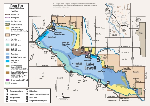
Map of Lake Lowell Unit
The Lake Lowell Unit has many facilities and access points. Click on "Image Details" below map for larger version of map.
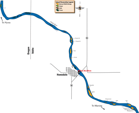
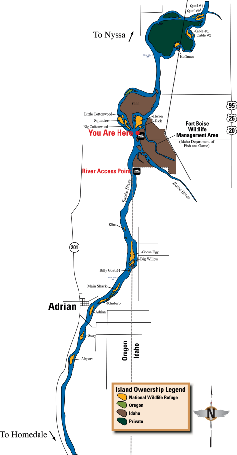
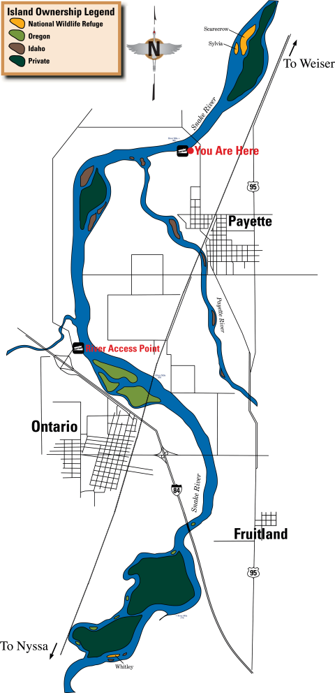
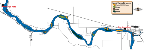
Maps of Snake River Islands Units
The 104 Refuge Islands in the Snake River are distributed from the Canyon-Ada County line in Idaho to Farewell Bend in Oregon. Boat ramps to access these islands are available at the upstream to downstream locations listed below.
- Celebration Park, ID. Follow signs from Highway 45
- Walter's Ferry, ID. Where Highway 45 crosses the river. Click on "Image Details" below map for larger version of map.

- Bernard's Ferry, ID. About 5 miles west of Walter's Ferry on Highway 78
- Marsing, ID. Where Highway 55 crosses the river. Click on "Image Details" below map for larger version of map.
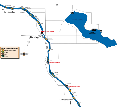
- Homedale, ID. About a half mile west of Highway 95. Click on "Image Details" below map for larger version of map.
- Adrian Bridge, OR. Unimproved ramp about one mile east of Highway 201
- Fort Boise, ID. Inside the Fort Boise Wildlife Management Area. Click on "Image Details" below map for larger version of map.
- Nyssa, OR. Click on "Image Details" below map for larger version of map.

- Ontario State Park, OR. At the Highway 201 exit off of I-84
- Centennial Park, Payette, ID. Click on "Image Details" below map for larger version of map.
- Roberts Landing, ID. Follow signs off of Highway 95. Click on "Image Details" below map for larger version of map.
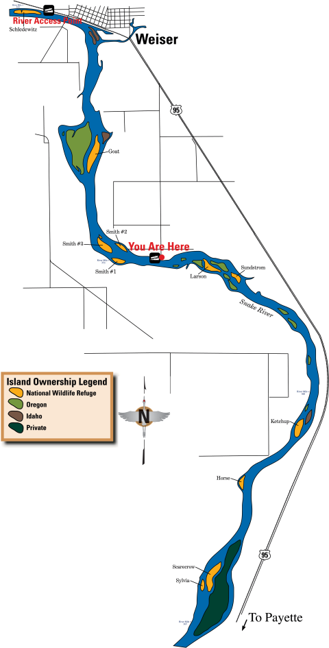
- Weiser, ID. Unimproved ramp about one mile west of Highway 95 on River Road
- Farewell Bend State Park, OR. Follow signs off of I-84. Click on "Image Details" below map for larger version of map.
Activities
There are many ways to enjoy your refuge! Visitors can enjoy more than 10 miles of trails on foot or by bicycle or horseback, find a diversity of birds and other wildlife to watch or photograph, fish from shore or a boat. hunt in select areas of the refuge, enjoy a family picnic, go swimming or participate in free educational programs about nature. For more information, please call 208-467-9278 or email deerflat@fws.gov. Be safe, have fun, and learn something new about your wild neighbors.
Trails
Experience the refuge from different perspectives and wander through different habitats by exploring our 10+ miles of hiking trails.
While visiting, please remember these rules and pointers:
- Seasonal wildlife closures may be marked by signs.
- Visitors walking leashed dogs, jogging, biking, and horseback riding:
- These activities are allowed on designated trails only.
- Groups of more than 10 require a Special Use Permit.
- Dogs must be on a physical leash (6 feet or less) at all times. Pet waste must be removed.
- See specific trail information below to learn whether hiking is allowed off trail near a specific trail.
- During the summer, conditions can be very hot with limited shade opportunities.
- Preparing for your hike:
- No potable water is available on the trails. Bring water or bring a reusable bottle to fill at the filling station inside the visitor center during open hours.
- Wear appropriate clothing - Weather can change quickly. Summer sun can be intense and there are limited shade opportunities along trails. Winter winds can make you feel even colder.
- Wear sunscreen.
- Wear insect repellent to protect against mosquitoes and ticks.
- Please pack out what you pack in. Trash receptacles are only available at a few access points. We ask that you practice Leave No Trace ethics while visiting the refuge.
Trails near the Visitor Center
- Observation Hill Trail
- Nature Trail
- Sagebrush Trail
- Swallow Nest Trail
- Pollinator Trail
Trails in East Side Recreation Area
- Kingfisher Trail
- East Dike Trail
- Gotts Point Trail
Rules and Policies
Locations
Driving directions to the refuge visitor center
- Take Exit 33 off of Interstate 84.
- After exiting the freeway, turn right (west) onto Highway 55/Karcher Road.
- Follow Karcher Road about 3.5 miles to Lake Avenue.
- Turn left onto Lake Avenue and drive about 2.5 miles to the intersection with Roosevelt Avenue.
- Turn right onto Roosevelt Avenue.
- At Indiana Avenue at the top of the hill, turn left into the refuge and follow the road to the visitor center