

The U.S. Fish and Wildlife Service is seeking public comments on the proposed draft Compatibility Determination for utility rights-of-way to the Pines Recreation Area on Charles M. Russell National Wildlife Refuge for NorVal Electric Cooperative and Nemont Telephone Cooperative. Public comments will be accepted from July 13, 2026 to July 26, 2026. The document can be found in our Library.
Visit Us
Encompassing approximately 1.1 million acres, Charles M. Russell National Wildlife Refuge provides a rare opportunity to experience wild lands and wildlife in a natural setting. Visitors to the Refuge can enjoy wildlife and scenic grandeur in nearly the same surroundings as encountered by the Lewis and Clark Expedition in 1805.
Due to the Refuge's immense size and remote location, visitors should be prepared for a variety of conditions. Temperatures can range from 100ºF in the summer to -20ºF in the winter. While the Refuge has many miles of vehicle trails open for travel, many of these trails are "primitive" and require a high clearance vehicle and/or four-wheel drive. During wet weather, most trails are impassable. Plan to carry water with you as it is extremely limited on the refuge and drinking water is generally unavailable. Cell phone service is sporadic.
Activities
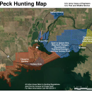
Hunting and fishing opportunities abound on Charles M. Russell National Wildlife Refuge. Boating is popular on the Missouri River and Fort Peck Reservoir. Several recreational areas have been developed within the refuge and excellent wildlife viewing and photography opportunities are found throughout the refuge. Each fall, hundreds of elk congregate in the Slippery Ann Wildlife Viewing Area, creating a spectacle not to be missed. Camping, hiking and horseback riding are permitted.
Related Documents
If you would like a map of the refuge mailed to you, please email or call.
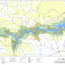
A georeferenced PDF map is available below as well as several other helpful PDF maps showing the Fort Peck area and the Charles M. Russell Wetland Management District, Waterfowl Production Areas and satellite refuges.


Other Facilities in the Complex
This refuge is managed as part of the Charles M. Russell Complex. A National Wildlife Refuge Complex is an administrative grouping of two or more refuges, wildlife management areas or other refuge conservation areas that are primarily managed from a central office location. Refuges are grouped into a complex structure because they occur in a similar ecological region, such as a watershed or specific habitat type, and have a related purpose and management needs. Typically, a project leader or complex manager oversees the general management of all refuges within the complex and refuge managers are responsible for operations at specific refuges. Supporting staff, composed of administrative, law enforcement, refuge manager, biological, fire, visitor services, and maintenance professionals, are centrally located and support all refuges within the complex.
Charles M. Russell National Wildlife Refuge is the only staffed refuge in the Complex. Other refuges in the Charles M. Russell Complex include:


Rules and Policies
Many wildlife-oriented recreational opportunities are offered at Charles M. Russell Refuge, including hunting, fishing, photography, wildlife observation, and hiking.
This page outlines Refuge regulations and information that will help ensure your Refuge visit is safe and enjoyable. Observe the following regulations to protect yourself and Refuge resources. Activities not described here are prohibited on the Refuge.
Locations
Charles M. Russell National Wildlife Refuge is located in north-central Montana. The headquarters for the refuge complex is located in Lewistown, MT and two staffed field stations are located on the east and west ends of the refuge. The Sand Creek Field Station is located on the west end and the Fort Peck Field Station is on the east side.
To visit the Charles M. Russell National Wildlife Refuge headquarters: From Great Falls, follow U.S. Highway 87 east for 100 miles to Lewistown. Turn right onto Airport Road. From Billings, follow U.S. Highway 87 north to Grass Range and then west to Lewistown for 130 miles. Turn left onto Airport Road. The refuge headquarters is located about one mile up the road to the left.
The Fort Peck Field station manages the east half of Charles M. Russell National Wildlife Refuge.
From US Highway 2, turn onto MT-117 and drive south for 10 miles. The field station will be on the left.
The Sand Creek Field Station manages the west half of Charles M. Russell National Wildlife Refuge.
Sand Creek Wildlife Station is located 2 miles south of the Missouri River on the east side of U.S. Highway 191.
The Fort Peck Interpretive Center, a cooperative effort between the U.S. Army Corps of Engineers and the U.S. Fish and Wildlife Service, is located in the town of Fort Peck, MT. It features exhibits about wildlife, paleontology and the history and construction of the Fort Peck Dam. Visit the Interpretive Center's page to learn more.
To visit the Fort Peck Interpretive Center: From U.S. Highway 2, turn south on Montana Highway 117. Follow for 10 miles. Continue straight on Yellowstone Road for 1.5 miles to the Interpretive Center. From Montana Highway 24, turn northeast on Montana Highway 117. Follow for two miles. Turn right on Yellowstone Road and continue 1.5 miles to the Interpretive Center.