Library
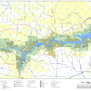
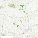
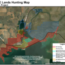
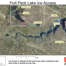
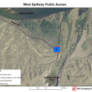
Visit our Library for a map of the Refuge showing roads and Recreation Areas. You can also find maps of the Fort Peck area including hunting maps and trails maps.
Official websites use .gov
A .gov website belongs to an official government organization in the United States.
Secure .gov websites use HTTPS
A lock ( ) or https:// means you’ve safely connected to the .gov website. Share sensitive information only on official, secure websites.
Visit our Library for a map of the Refuge showing roads and Recreation Areas. You can also find maps of the Fort Peck area including hunting maps and trails maps.