


About Us
The following are the Charles M. Russell Wetland Management District WPAs:
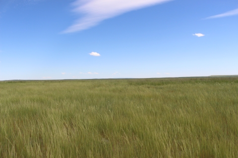
James L. Hansen WPA is located in Stillwater County and was acquired in January 2023 using Migratory Bird Conservation Funds from the sale of Duck Stamps. The unit is 2,683 acres in total, with approximately 450 acres comprising deepwater habitat, 1,403 acres emergent wetland habitat, and the remaining 830 acres upland habitat. The WPA is adjacent to the Big Lake Wildlife Management Area administered by Montana Fish, Wildlife, and Parks. The mixed-grass prairie grassland community type adjacent to the seasonal wetland and lake area attracts a wide diversity of wildlife, providing excellent observation opportunities. Waterfowl, upland game birds (sharp-tailed grouse, Hungarian (grey) partridge, and occasional pheasants), mule deer, pronghorn, and numerous other non-game species such as grassland nesting songbirds can be observed either year-round or seasonally.
The prairie dog town located within the WPA provides critical habitat for burrowing owls, horned larks, killdeer, thick-billed longspur, and occasional mountain plovers, a Montana species of concern.

War Horse WPA is a 40-acre tract in Petroleum County established in October of 1997 that lies between and connects the two War Horse Unit sections of War Horse NWR and is adjacent to War Horse Reservoir. The upland habitat in this WPA is important for waterfowl and grassland-savanna nesting birds, as well as mule deer and antelope.

Hailstone WPA encompasses 1,828 acres in Stillwater County and surrounds Hailstone NWR on three sides. It was established in October of 1979. The lowland area historically contained an earthen dam. Over the years heavy metals and salts accumulated in the reservoir and surrounding soil due to natural evaporation. In 2011, the earthen dam was removed to re-create a free flow through system. Greasewood grows in the saline soils whereas native grasses flourish in less saline areas. Wildlife species include waterfowl, water birds, pronghorn, mule deer, grassland nesting birds, and prairie dogs. Many other small mammals exist along with horned lizards (often referred to as horned toads), and rattlesnakes. These shortgrass prairie habitat species all complement each other.

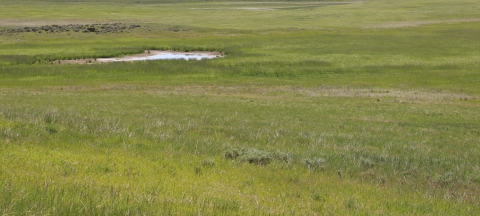
Spidel WPA was established in November of 1980 and lies in Golden Valley and Yellowstone counties. It comprises 1,247 acres and contains 700 acres of drained wetland. The wetland acreage was drained years ago by previous owners in an effort to increase crop production. Despite the reduced size of the wetland, large numbers of waterfowl and shorebirds can still be found at Spidel WPA, particularly in wet spring years. Grassland nesting birds and upland game birds also thrive in the dense upland habitat. The Service plans to restore the wetland in the future.
Tew WPA is a 532-acre tract of land established in October of 1980 and located in Musselshell County. It is one of a few areas in central Montana with natural temporary and seasonal wetland basins. It contains six wetland basins: three temporary (semi-permanent) and three seasonal. The basins are in small watersheds, and above-average precipitation and surface runoff are required to fill them. Uplands in this WPA have been seeded to dense nesting cover (a mixture of grasses and legumes) which supply cover for nesting female ducks, as well as grassland nesting birds and upland game birds. When wet, the area provides excellent nesting and brood-rearing habitat for waterfowl and other wildlife species.
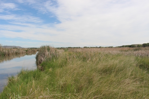
Clark's Fork WPA was acquired in 1991 through the FmHA (Farmers Home Administration) and is managed as a WPA. It is 271 acres having 1.5 miles of river frontage along the Clark’s Fork of the Yellowstone River. After acquisition, the Service coordinated a wetland creation project 66 acres in size, working jointly with Ducks Unlimited and Montana Fish, Wildlife and Parks. The wetland is surrounded by excellent dense nesting cover (a mixture of grasses and legumes which provide cover for nesting female ducks).
The narrowleaf cottonwood/red-osier dogwood community type along the river attracts a wide diversity of wildlife, providing excellent observation opportunities. Waterfowl, pheasants, white-tailed deer, and numerous other non-game species can be observed either year-round or seasonally.
The Charles M. Russell Wetland Management District contains Refuge and flowage easements, Farmer’s Home Administration (FmHA) easements, and State-issued grazing leases. More information about the District's easements are as follows:
The Service manages five FmHA conservation easements:
- Hardy Tract was obtained in 1989 and is a 120-acre conservation easement conservation easement
A conservation easement is a voluntary legal agreement between a landowner and a government agency or qualified conservation organization that restricts the type and amount of development that may take place on a property in the future. Conservation easements aim to protect habitat for birds, fish and other wildlife by limiting residential, industrial or commercial development. Contracts may prohibit alteration of the natural topography, conversion of native grassland to cropland, drainage of wetland and establishment of game farms. Easement land remains in private ownership.
Learn more about conservation easement located in Custer County. A 43-acre semipermanent wetland was created in 1990 in cooperation with Ducks Unlimited and Montana Fish, Wildlife & Parks. Water for this project was purchased from the Tongue and Yellowstone Irrigation Company and obtained via a diversion in a nearby ditch. - Kurz Tract was obtained in 1998 and is a 100-acre conservation easement in Bighorn County. The tract is adjacent to the Bighorn River.
- Overturf Tract was obtained in 1988 and is a 25-acre conservation easement in Bighorn County. The tract is adjacent to the Little Bighorn River.
- Weyer Tract was obtained in 1997 and is a 960-acre conservation easement in Wibaux County.
Jansen Tract was obtained in 2000 and is a 280-acre conservation easement in McCone County. Hay cutting and grazing are allowed as provided for in a management plan jointly developed and agreed to by the Service and Natural Resources Conservation Service.
Flowage Easements
The initial objective of flowage easements was to allow the Works Progress Administration to enhance wetland basins. Later, in the 1980s, most of the lands encumbered by easement were purchased in fee-title at Hailstone NWR and Grass Lake NWR. The easements at Lake Mason NWR and along Willow Creek were never fully developed. Only the Miller Lake project (Lake Mason NWR) was attempted and is now in a nonfunctional stage. The current acreage of flowage easements: Hailstone NWR (760 acres), Grass Lake NWR (400 acres), and Lake Mason NWR (5,502 acres). An easement for protection of wildlife habitat was retained on 560-acres of land that was divested during the 2004 land exchange at the Yellow Water Unit (War Horse NWR). This easement requires that the permanent vegetative cover be retained on these lands and cannot be altered unless prior approval in writing is granted by the Service.
Satellite Refuges
There are four satellite Refuges that lie within the boundaries of the District. They are as follows:
Lake Mason NWR: https://www.fws.gov/refuge/lake-mason
Hailstone NWR: https://www.fws.gov/refuge/hailstone
War Horse NWR: https://www.fws.gov/refuge/war-horse
Grass Lake NWR: https://www.fws.gov/refuge/grass-lake
Our Mission
The mission of the National Wildlife Refuge System is to administer a national network of lands and waters for the conservation, management and, where appropriate, restoration of the fish, wildlife and plant resources and their habitats within the United States for the benefit of present and future generations of Americans.