


Visit Us
National wildlife refuges offer us all a chance to unplug from the stresses of daily life and reconnect with our natural surroundings.
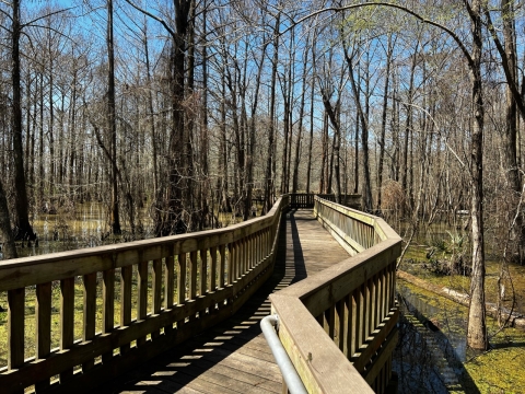
To see the most wildlife, drive around Shoveler Pond, a 2.6 mile auto loop where you can see a variety of birds, reptiles, and small mammals. From there you can walk a short boardwalk overlooking the marsh. If you have more time, enjoy the Butterfly Garden or a walking trail where you can peacefully experience our wildlife and scenery. Consider sitting at an observation platform or wildlife blind to enjoy photography opportunities.
You can also enjoy excellent wade fishing on the refuge's shoreline and freshwater fishing along beautiful bayous. Some of the best waterfowl hunting opportunities in Southeast Texas are available seasonally too. Contact the refuge for a hunting brochure and more information.
Driving Directions
The Main Visitor Center/Headquarters is east of Houston and is located 2-miles south of I-10 and north of the City of Anahuac. Driving from Houston or Beaumont, take Interstate 10 and Exit 810 to FM 563. The Main Visitor Center/Headquarters will be a large building on FM 563 on the west side of the road. The GPS coordinates are 29.822737, -94.663653. The address is 4017 FM 563, Anahuac TX 77514.
Anahuac National Wildlife Refuge is located off of FM 1985 in Chambers County, Texas. To reach the refuge from the Main Visitor Center (north of the City of Anahuac), continue south on FM 563 for 4 miles until you reach a four-way stop in the City of Anahuac. Take a left onto Hwy 61 and drive east for 2 miles until you reach another four-way stop. Turn right onto FM 563 and continue south for 8 miles until the road splits. Bear left onto FM 1985 (Whites Ranch Road) and drive 4 miles until you reach the refuge entrance.
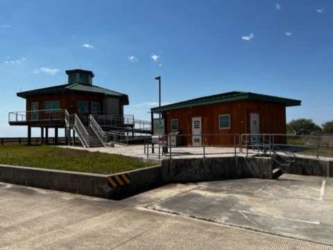
The seasonal Visitor Information Station (VIS) is located on the main portion of Anahuac National Wildlife Refuge off of FM 1985. The VIS is a small, round building approximately 3 miles south of FM 1985 along the refuge entrance road. The GPS Coordinates for the VIS are 29.6119092, -94.5350045.
Fees
There is no charge to visit.
Restrooms
Restrooms are available in the breezeway of the Main Visitor Center, outside of the Visitor Information Station (VIS), across from the Butterfly Garden, at the Skillern Tract, East Bay Boat Ramp, and at Frozen Point.
Points of Interest
Stop by our Visitor Center on FM 563 to explore interactive wetland displays, grab an animal checklist, talk to volunteers about earning Jr. Ranger Badges, and best of all watch two movies in our Airboat Theater. Multiple educational displays in the breezeway offer information about nearby refuges and offer maps and brochures. While there, visit the Friends of Anahuac Refuge Nature Shop for field guides, t-shirts, and other educational items. Be prepared to learn about live animals and explore the Cypress Trail on your way out.
After you do all these fun activities, take a trip to the refuge on FM 1985 to explore the Butterfly Garden, see how many alligators you can count around the Shoveler Pond Auto Tour Loop, and visit our Visitor Information Station to learn more about wildlife, photography, and fishing on the refuge.
What to Do
If you have 15-minutes:
- Enjoy the Butterfly Garden or explore exhibits in either Visitor Center.
If you have one hour:
- View wildlife from your car along any refuge road, or consider walking the Cypress Trail, Willows Trail, or Hackberry Trail.
If you have half a day or more:
- Drive around the Shoveler Pond Auto-Tour Loop, stopping for the Boardwalk Trail and multiple pullouts. Afterwards, take a stroll on any of our trails.
Know Before You Go
Before you visit make sure you are prepared for the weather and the wildlife. Bring plenty of fuel, drinking water, snacks, bug repellant, and sunscreen. There are bathrooms, but no drinkable water available. The marsh’s dangerous animals consist of insects and snakes – so we encourage you to be aware of where you step and where you choose to stand.
Visitor Tips
Early in the morning and around sunset are the best times to view wildlife. The weekdays are the least busy, while the weekends have the most visitors. Binoculars are available to borrow from the visitor centers free of charge. Visit any sign kiosk in front of the Main Visitor Center or the Visitor Information Station for brochures and maps.
Activities
All ages and abilities are welcome to enjoy a variety of wildlife friendly recreation at Anahuac National Wildlife Refuge. From birding to boating, fishing, hunting, and educational events — enjoy your public lands and live your wild with us!
Trails
Cypress Trail
Open Season: Year Round; Sunrise to Sunset
Length: 0.25 miles one-way
Location of trail: Behind the Main Visitor Center on FM 563
Surface Paved, Boardwalk, ADA compliant
Difficulty: Easy
The Cypress Trail meanders through bottomland hardwood forest full of oaks, hackberry, sweetgum, and pine. It leads visitors to a long boardwalk towards the peaceful Lake Anahuac. Wading birds, terns, gulls, raptors, woodpeckers, wood ducks, warblers, turtles, otters, and mink can be seen here.
A separate 0.1-mile (0.16 km) paved path branches off this trail and leads to a wildlife photography blind. This is a great place to see finches, sparrows, woodpeckers, vireos, tanagers, and fly-catchers.
Honeysuckle Trail
Open Season: Year Round
Length: 0.10 miles
Location of trail: Skillern Tract
Surface : Grass
Difficulty: Easy
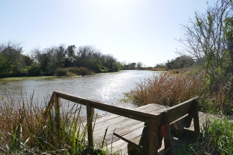
The Honeysuckle Trail offers a very short 0.1-mile (0.16 km) grass path through shrubs to a scenic knoll and large fishing deck. The trail starts at a parking lot on the corner of the main road. Wading birds, gulls, terns, raptors, woodpeckers, wood ducks, mottled ducks, warblers, finches, sparrows, vireos, tanagers, and fly-catchers can be seen in this area.
This is also a good place to catch catfish and gar.
Hackberry Trail
Open Season: Year Round
Length: 0.67 miles
Location of trail: Main refuge off of FM 1985
Surface: Gravel
Difficulty: Moderate
The Hackberry Trail is a 0.67-mile (1.08 km) trail that borders a moist-soil unit. The straight gravel path offers two accessible observation platforms. Wading birds, plovers, sandpipers, rails, and a large species of waterfowl (during the fall and winter) can be seen from the observation platforms.
Sparrows, finches, vireos, warblers, rails, kingfishers, and raptors.

Live Oak Trail
Open Season: Year Round; subject to closures during flooding
Length: 1.00 mile
Location of trail: Skillern Tract
Surface: Grass
Difficulty: Moderate
The Live Oak Trail offers a 1-mile (1.6 km) vegetated path following East Bay Bayou. The south end of the trail has a paved parking lot, bathrooms, and a separate sidewalk leading to an accessible wildlife observation deck. On the north end of the trail a grassy levee provides access to a more primitive parking area and a rustic fishing deck along the trail.
Wading birds, gulls, terns, raptors, woodpeckers, wood ducks, mottled ducks, warblers, finches, sparrows, vireos, tanagers, and fly-catchers can be seen in this area.
Rookery Trail
Open Season: Year Round
Length: 0.24 miles
Location of trail: Skillern Tract
Surface: Paved, Accessible
Difficulty: Easy
The Rookery Trail offers an accessible 0.24-mile (0.39 km) paved path to a wooded observation deck. Take a stroll through some of our thickest woods and come out overlooking the beginnings of a rookery project.
Wading birds, gulls, terns, raptors, woodpeckers, wood ducks, mottled ducks, warblers, finches, sparrows, vireos, tanagers, and fly-catchers can be seen in this area.
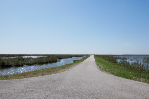
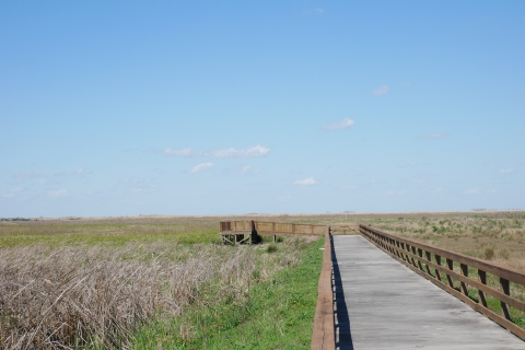
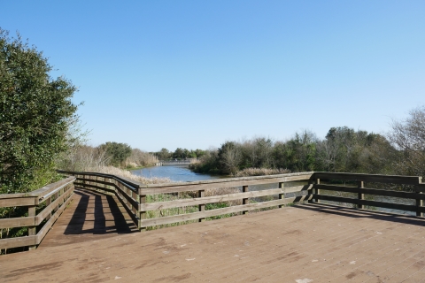
Shoveler Pond Auto Tour Loop and Boardwalk Trail
Open Season: Year Round
Length: 2.64 mile tour loop and 0.14 mile boardwalk
Location of trail: Main refuge off of FM 1985
Surface: Paved, Boardwalk, Accessible
Difficulty: Easy
Wildlife enthusiasts in search of a lot of alligators will most definitely enjoy the 2.64 mile (4.25 km) Shoveler Pond auto tour loop. A boardwalk and overlook along this route provide excellent opportunities to enjoy the sites and appreciate the sounds. This is a must experience for anyone visiting the refuge!
Gallinules, roseate spoonbills, ibis, herons, egrets, wrens, warblers, buntings, rails, and blackbirds are seen in this area.
During the fall and winter there are large and diverse populations of waterfowl.
Willows Trail and Butterfly Garden
Open Season: Year Round
Length: 0.71 miles
Location of trail: Main refuge off of FM 1985
Surface: Grass, Paved, Boardwalk, Accessible
Accessible and family-friendly, the Butterfly Garden provides a colorful space for everyone to appreciate the joys of nature. Monarchs, fritillaries, and swallowtails dance among the flowers and lay their eggs on the native host plants. The paved path of the Butterfly Garden also connects you to the Willows Trail. Search for small birds as you stroll the boardwalk one way, and then continue as you take the grassy path back. Enjoy this world-renown birding hotspot and take note of the changing plants and habitats around you. Bring plenty of water and bug spray!
Grosbeaks, tanagers, buntings, catbirds, sparrows, and warblers can be seen at the butterfly garden
Along with those species you'll also see thrushes, thrashers, along the willows trail.
Woodlot Trail
Open Season: Year Round
Length: 0.12 miles
Location of trail: Main refuge off of FM 1985
Surface: Paved
Difficulty: Easy
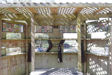
Hands down, this trail offers the best birding for warblers, buntings, and vireos. This solitary clump of giant trees provides crucial habitat for many of the migratory birds that have just flown 600 miles across the Gulf of Mexico and are exhausted. For many of these small birds, the Woodlot is their first opportunity to find food and shelter. Sit quietly at the Toni Marchetti bird blind and watch the amazing activity of birds as they hydrate at our newly designed water feature and work to regain their strength for the rest of their migration.
Fly-catchers, sparrows, blackbirds, cuckoos, nighthawks, swifts, hummingbirds, rails, owls, raptors, wading birds, and much more. 244 species of birds have been identified at this trail.
Related Documents

Rules and Policies
This is where you can enjoy wildlife-related activities, including wildlife watching, hiking, fishing, and photography. Free of charge, Anahuac National Wildlife Refuge is open seven days a week from one hour before sunrise until one hour after sunset, unless otherwise posted. We welcome you to enjoy your public lands and admire the wonders of the natural environment with us, and we thank you for being safe and respectful to the wildlife and fellow visitors.
Locations
The main entrance to the wildlife refuge gives visitors access to the Oyster Bayou Boat Ramp, the East Bay Boat Ramp, Frozen Point, Shoveler Pond, our butterfly garden, the Visitors Information Station, and a number of trails. Along with the 2.64 mile Shoveler Pond auto loop, the trails include: the Hackberry Trail, the Boardwalk Trail, the Woodlot Trail, and the Willows Trail.
The seasonal Visitor Information Station (VIS) is located on the main portion of Anahuac National Wildlife Refuge off of FM 1985. The VIS is a small, round building approximately 3 miles south of FM 1985 along the refuge entrance road. The GPS Coordinates for the VIS are 29.6119092, -94.5350045. The phone number for this seasonal visitor information station is 409-252-4311.
Anahuac National Wildlife Refuge is located off of FM 1985 in Chambers County, Texas. To reach the refuge coming from Beaumont on I-10 take exit 813 for TX-61 and to reach the refuge coming from Houston on I-10 take exit 812 for TX-61. Take TX-61 south for 3.9 miles until you reach a four-way stop. Continue straight onto FM 562 for 8.2 miles until you reach a fork in the road. Turn left and take FM 1985 for an additional 4.3 miles and Anahuac Wildlife Refuge will be on your right.
The seasonal Visitor Information Station (VIS) is located on the main portion of Anahuac National Wildlife Refuge off of FM 1985. Binoculars are available to rent, as well as snacks, drinks, books, and keepsakes. There are also restrooms and a kiosk with a variety of brochures located adjacent to the VIS. The GPS Coordinates for the VIS are 29.6119092, -94.5350045.
After accessing the main entrance of the wildlife refuge off of 1985, continue south for 3.3 miles and the VIS will be on your right.
The Visitors Center has a seasonal gift shop and outdoors education center, as well as access to our Cypress Trail and a wildlife photography blind.
The Main Visitor Center/Headquarters is east of Houston and is located 2-miles south of I-10 and north of the City of Anahuac. Driving from Houston or Beaumont, take Interstate 10 and Exit 810 to FM 563. The Main Visitor Center/Headquarters will be a large building on FM 563 on the west side of the road. The GPS coordinates are 29.822737, -94.663653. The address is 4017 FM 563, Anahuac TX 77514.
The Skillern Tract contains 314 acres of moist soil units, rice fields, and wooded areas along East Bay Bayou. Featuring three trails, two observation decks, three fishing decks, and a non motorized boat launch, the Skillern Tract offers a variety of recreational opportunities for everyone.
From the main entrance to Anahuac Wildlife Refuge, continue east for 7.4 miles and the entrance to the Skillern Tract will be on the south side of the road.
The beach at the South Unit of Anahuac NWR is open to the public year round and does not require a Bolivar parking permit. This is an excellent place to fish, relax, and comb the beach.
The East Unit public hunting area is for waterfowl hunting only and access is restricted outside of waterfowl hunting season. There are over 50 hunting spots that must be reserved in advance of the day which you intend to hunt.
From the main entrance to Anahuac Wildlife Refuge, continue east for 6.6 miles and the entrance to the East Unit public hunting area will be on the south side of the road.