Red-cockaded woodpecker (RCW) Project Review Moore County, North Carolina

A red-cockaded woodpecker feasts on a bug.

Introduction

The Moore County, NC RCW Online Project Review Process is intended for use by landowners, applicants, and consultants in the sandhills of North Carolina, who are seeking U.S. Fish and Wildlife Service (Service) review or approval of their project with respect to impacts to red-cockaded woodpecker (RCW). The goal is to streamline the project review process for impacts to RCW and RCW habitat in the North Carolina sandhills, and to efficiently provide accurate documentation for project proponents when minimal impacts are anticipated.  Another goal is to ensure that trust resources are considered and conserved while planning and conducting development activities. This online review process only considers RCW and RCW habitat in the sandhills area of North Carolina. Please complete this online process before contacting our office. If there are other federally listed species that may be affected by your project, or if your project is in a different area of the state, please go to theProject Planning and Consultation page.

Note! For properties within Forest Creek Golf Course or Pinehurst National #9, please continue to use the established process for RCW project review in those areas. (i.e., required to submit lot information including tree count and maps in these communities, regardless of red or clear zones). We work with Forest Creek Golf Course and Pinehurst National #9 through past and ongoing consultation and agreements to minimize habitat loss as each parcel is developed. New construction must comply with standards set by architectural review and agreed to by the Service.

Instructions for Online Project Review for Moore County, NC:

Step 1. Mapping

Eric Spadgenske holding a female Red-cockaded Woodpecker

Consult the NC Sandhills RCW Color-Coded Maps to determine where your property/project falls on a Red Zone or a Clear Zone (no color).  If in a Clear Zone, fill out and print self-certification letter, retain the letter for your records and submit a copy of the letter to the Service at Raleigh@fws.gov for this certification to be valid. If in a Red Zone, move on to Step 2.

  1. Using the Moore County Overview Map, locate the general area where the property/project is located and pick one of the following maps to pinpoint the exact location:  

If the project/property falls in a Clear Zone (no color):

You may fill out and print thisself-certification letter. Retain the letter and project information for your records and submit a copy of this letter to the Service at Raleigh@fws.gov for this certification to be valid.

If the project/property falls on the map in the Red Zone:

A qualified environmental consultant should survey the property for cavity trees and put together a project review package as described in the next steps.  A package must be submitted to the Service as instructed in Steps 2 and 3.  Do not proceed with work until you receive a response from the Service indicating that work can proceed. 

Step 2. Project Information

Red-cockaded woodpecker nesting trees identified with a white band of paint.

Gather information for your project (site plans, project plans, methods, RCW survey information, tree survey information).

Fill in and print Project Review Request Letterand submit the letter with a project review package to the Service as instructed in Step 3.

Refer to these documents forsurvey protocol and instructions to determineForaging Habitat Availability.

For property or activities in the Red Zone of Moore County, NC (see map), gather the following information.

  • A site plan or map of the property.
  • Show existing buildings or other infrastructure.
  • Indicate the type of planned activity and the extent of the activity (for example: road crossing, fill, building construction, paving, application of herbicides, tree removal, encroachment within 50 feet of cavity tree by vehicles, etc.). 
  • Indicate the location of any pine trees with more than 8-inch diameter at breast height (dbh), and especially demarcate any RCW cavity trees that may be present. 
  • Show the location of any pine trees with more than 8-inch dbh that are proposed to be removed.
  • A narrative of the planned activity – including a description of the activity, the equipment and methods to be used, time of year that the work will take place, and the length of time to complete the project in days, weeks, or months. The narrative should include a discussion of number and size of trees proposed for removal and reasons for removal (please include an explanation of why tree removal cannot be avoided or further minimized).
  • Copies of the RCW survey reports and any other RCW data for the property.

Additional information that may be helpful for making a determination:  

  • Photographs
  • Aerial images
  • History of site development (if applicable)

Complete and printa request for review letterand submit it to the Service as instructed in Step 3. 

This letter is to be used as a cover letter to request a review from the Raleigh Field Office. 
The Service will review the package and provide a written response, typically within 60 days. Work on the project should not proceed until consultation with the Service is completed.

Step 3. Submit Project Review Package (as applicable)

If your project is in a Red Zone, it requires review, submit a complete package to the Raleigh Field Office at the following address:

  • Email (Preferred):  Raleigh@fws.gov
  • Mailing address: FISH AND WILDLIFE SERVICERaleigh ES Field Office, Post Office Box 33726, Raleigh, North Carolina 27636-3726

Project Review Packages should include, at a minimum, the following information:

The Service will strive to respond within 30 days of receipt; however, capacity limitations and increased workload may affect response time, which may take 60 days (50 CFR 402.13(c)(2)). Do not proceed with work until you receive a response from the Service indicating that work can proceed.If your project changes, or if new information is discovered, you should provide the new information to the Service for consideration.

Frequently Asked Questions:

1. Q:  If my property is only partly within a red zone, is it considered “in” or “out?”

A: If any portion of the lot is located within a red zone, then consider it to be “in” the respective zone. 

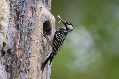
2. Q:  When are cavity tree surveys required?

A:  Surveys are required in a red zone when proposing to remove trees greater than or equal to 8 inches dbh.  Surveys are not required prior to tree removal in a clear (no color) zone.

3. Q:  Where can I find guidance or instructions for conducting surveys?

A: Surveys should be conducted by a qualified environmental consultant and should follow the Service’s Survey Protocol, contained in Appendix 4 of the RCW Recovery Plan.

4. Q:  I have submitted Letter #1 and my project review package to theService, and I would like to receive a response from the USFWS, even if there are no concerns. How do I get a response?

A:  The Service intends for Letter #1 to provide adequate documentation of compliance with Section 9 of the ESA. Please contact us if you have additional questions.