


About Us
The Hanford Reach National Monument, comprising over 196,000 acres in arid eastern Washington, was the first national monument national monument
A national monument is established by executive order of the president or by Congressional legislation. The Antiquities Act authorizes the president to proclaim “historic landmarks, historic and prehistoric structures, and other objects of historic or scientific interest” as national monuments. The National Wildlife Refuge System helps manage three national monuments: Hanford Reach National Monument in Washington state, Aleutian Islands World War II National Monument in Alaska and Tule Lake National Monument in California.
Learn more about national monument for the U.S. Fish & Wildlife Service and broke the mold, so to speak, of what a national wildlife refuge national wildlife refuge
A national wildlife refuge is typically a contiguous area of land and water managed by the U.S. Fish and Wildlife Service for the conservation and, where appropriate, restoration of fish, wildlife and plant resources and their habitats for the benefit of present and future generations of Americans.
Learn more about national wildlife refuge is. Yes, there is abundant wildlife, endangered species, and unique ecosystems. However, no other refuge is so focused on history, cultural resources, geology, paleontology, and other non-wildlife-related resources. Throw in an eligible wild and scenic river—rare for the agency outside of Alaska—and the FWS had to rethink how to manage resources with which it typically had little experience.
Our Mission
The mission of the National Wildlife Refuge System is “To administer a national network of lands and waters for the conservation, management, and where appropriate, restoration of the fish, wildlife, and plant resources and their habitats within the United States for the benefit of present and future generations of Americans.”
The Monument was established to protect “antiquities” and to set aside lands for scientific purposes. The Presidential Proclamation for the Monument defines the reasons the Monument was established and the purposes for which it is to be managed. The resources specifically mentioned include:
- A shrub-steppe ecosystem, including breeding populations of steppe and shrub-steppe dependent birds such as loggerhead shrikes, sage sparrows, sage thrashers, and ferruginous hawks.
- Water-related resources, including the 46.5 miles of the 51-mile long Hanford Reach of the Columbia River, fall Chinook salmon spawning areas, and sturgeon.
- A diversity of native plant and animal species, including rare and sensitive plant species such as Umtanum desert buckwheat and White Bluffs bladderpod; habitat for migratory birds, as well as resident species, including wintering habitat for bald eagles, white pelicans, and ducks; nesting sites for rare bird species, including prairie and peregrine falcons; and insect species new to science or not previously identified in the state of Washington.
- Microbiotic crusts.
- Significant geological and paleontological objects, such as the White Bluffs and Hanford Dune Field, and mammalian fossils of rhinoceros, camel, mastodon and others.
- Important archaeological and historic artifacts from more than 10,000 years of human occupation, including prehistoric pit houses, graves, spirit quest monuments, hunting camps, game drive complexes, quarries, hunting and kill sites, and more recent human activity such as homesteads and early towns.
Our History
The land comprising the Monument has an unusual and colorful provenance. The entry of the United States into World War II and the race to develop an atomic bomb led to a search for a suitable place to locate plutonium production and purification facilities. In 1943, the War Department (later to become the Department of Defense) went in search of a remote, easily defensible, geologically stable site, with plenty of cool water, abundant energy (from hydropower dams on the Columbia River), and a moderate climate, on which to build secret plutonium production reactors. The U.S. Army Corps of Engineers selected a site in Washington State near the isolated desert towns of White Bluffs and Hanford. The War Department acquired land through condemnation and purchase of private lands and withdrawal of public lands within the basin formed by Rattlesnake Mountain and the Saddle Mountains. The Atomic Energy Commission, a precursor to the Department of Energy, then established and ran the Hanford Site (then known as the Hanford Engineering Works).
For more than forty years, the primary mission at the Hanford Site was the production of nuclear materials for national defense. The DOE developed infrastructure and facility complexes to accomplish this work in the central portion of the site, but large tracts of land were used as protective buffer zones for safety and security purposes and remained undisturbed. These buffer zones preserved a nationally significant biological and cultural resource setting in the Columbia Basin region, unique in that similar resources elsewhere in the Columbia Basin have been destroyed or replaced by development.
In the early 1970s, there was a reduced need for large safety and security buffer zones around the Hanford Site, and the DOE transferred management of portions of the “North” or “Wahluke Slope” (the area north of the Columbia River) to the FWS—through the creation of the Saddle Mountain National Wildlife Refuge—and to the Washington State Department of Fish and Wildlife. By the late 1980s, the primary DOE mission had changed from defense materials production to environmental restoration, waste management, and science and technology research, further decreasing the need for a large land base. In 1997, the DOE transferred the administration of the Fitzner-Eberhardt Arid Lands Ecology Reserve (ALE) to the FWS. In 1999, the Wahluke Slope lands managed by the WDFW, known as the Wahluke Wildlife and Recreation Area, were transferred to the FWS to be managed under DOE permit as part of the NWRS.
In the 1980s, concerns for protection of the Hanford Site’s natural and cultural resource values grew, as did interest in consolidating management under one natural resource agency. In 1988, Congress directed the Secretary of the Interior and the Secretary of Energy to identify and evaluate the outstanding features of the Hanford Reach and its immediate environment— including fish, wildlife, geology, scenery, recreation, historic and cultural values—and recommend alternatives for their preservation. The resulting Department of the Interior report, the Hanford Reach of the Columbia River Comprehensive River Conservation Study and Environmental Impact Statement, identified the FWS as best suited to protect those values and the lands necessary to support them. After years of discussion and controversy, the question of protection was settled when President Clinton created the Monument through his powers under the American Antiquities Act.
Other Facilities in this Complex
The four refuges that make up the Central Washington National Wildlife Refuge Complex have little in common, other than being in the state of Washington. That makes the Complex a wonderfully diverse blend of habitats, species, and recreational opportunities. There’s something to be found by everyone that will pique their interest or pull them into the landscape. A geology buff? Visit Columbia National Wildlife Refuge, carved by the great floods of the last ice age. Need a scenic landscape to paint or simply unwind in? Conboy Lake is the spot. Interested in our history? The Hanford Reach National Monument is the place to investigate. Want to add to your birding life list? Check the spring and fall migrations through Toppenish.
Columbia National Wildlife Refuge

Columbia National Wildlife Refuge is a scenic mixture of rugged cliffs, canyons, lakes, grasslands, and sagebrush sagebrush
The western United States’ sagebrush country encompasses over 175 million acres of public and private lands. The sagebrush landscape provides many benefits to our rural economies and communities, and it serves as crucial habitat for a diversity of wildlife, including the iconic greater sage-grouse and over 350 other species.
Learn more about sagebrush . The mix of lakes, carved by unimaginable floods during the last ice age, and surrounding irrigated croplands, a result Grand Coulee Dam and the Columbia Basin Irrigation Project, combined with generally mild winters and the protection provided by the refuge, attracts large numbers of migrating and wintering mallards, Canada geese, tundra swans, and other waterfowl. As winter turns to spring and frozen lakes begin to thaw, additional waterfowl return in great numbers. The largest concentrations of ducks, geese, and lesser Sandhill cranes arrive on the refuge in March and April, at times numbering over 75,000 individuals. The arrival of the cranes and other waterfowl draw visitors from all over the region, centering around the annual Othello Sandhill Crane Festival.
Conboy Lake National Wildlife Refuge
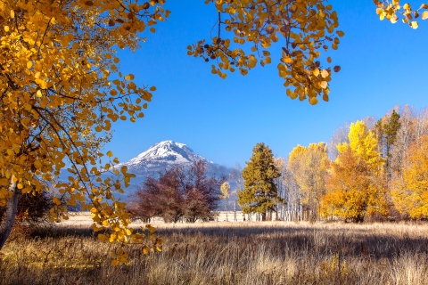
Nestled near the foot of snow-capped Mount Adams in Washington’s Cascade Range, Conboy Lake National Wildlife Refuge is a scenic gem within the National Wildlife Refuge System. The refuge encompasses 6,574 acres of lush seasonal marshes and vibrant forested uplands that beckon to both visitors and wildlife. A blend of wetlands; grassy prairies; streams; and oak, pine, and aspen forests supports a diverse wildlife community. The rich habitat sustains thriving populations of migrating waterfowl and songbirds. The rare Oregon spotted frog breeds in wetlands throughout the refuge. Elk are plentiful and frequently seen along refuge roads. Conboy Lake also supports most of the breeding population of greater Sandhill cranes in Washington. As a national wildlife refuge national wildlife refuge
A national wildlife refuge is typically a contiguous area of land and water managed by the U.S. Fish and Wildlife Service for the conservation and, where appropriate, restoration of fish, wildlife and plant resources and their habitats for the benefit of present and future generations of Americans.
Learn more about national wildlife refuge , this living system will satisfy your longing for splendor and serenity, just as it did for the indigenous peoples, explorers, loggers, and ranchers who were first drawn to the valley’s plentiful resources.
Toppenish National Wildlife Refuge
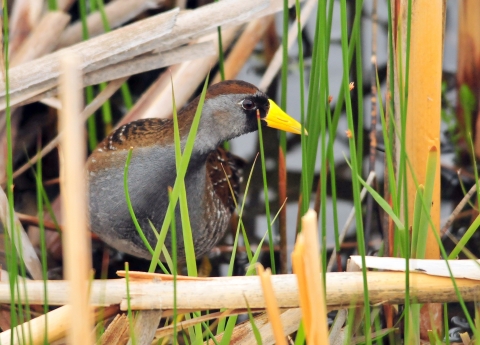
Toppenish National Wildlife Refuge, established in 1964, is an important link in the chain of feeding and resting areas for waterfowl and other migratory birds using the Pacific Flyway. Although Toppenish was established primarily for migratory waterfowl, many other migratory and resident wildlife species live here, such as American bitterns, peregrine falcons, badgers and beavers. The refuge is a broad collection of habitats supporting a diversity of species. Natural wetlands, such as sloughs and oxbows, and artificial wetlands are flanked by riparian riparian
Definition of riparian habitat or riparian areas.
Learn more about riparian areas. Many species of migratory waterfowl and nongame birds, such as Virginia rails and savannah sparrows, use the wetlands for feeding and nesting activities. Native shrub-steppe—characterized by greasewood, Wyoming big sage, rabbitbrushes, bitterbrush, and native bunchgrasses, such as Great Basin wildrye, Indian ricegrass, Idaho fescue, and Sandberg bluegrass—once covered the upland areas. Loggerhead shrikes, long-billed curlews, California quail, Brewer’s and sage sparrows, and sage thrashers are only some of the animals that use the shrub-steppe. This diverse combination of habitats is a natural magnet to migratory and resident wildlife, alike.


