


Visit Us
National wildlife refuges offer us all a chance to unplug from the stresses of daily life and reconnect with our natural surroundings. The refuge is open 365 days a year from sunrise to sunset. With over 60 miles of hiking and biking trail there is something for everyone. Laguna Atascosa considered to be one of the most biologically diverse refuges in North America.
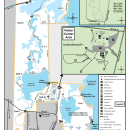
Driving Directions
- From Harlingen, McAllen, Mission, Edinburg, and points west and north: Take Highway 77 north (Corpus Christi/ Raymondville), take the exit for FM 106 (Rio Hondo) for 24 miles, turn left on Buena Vista Blvd, the Visitor's Center is located 3 miles north on the left.
- From South Padre Island: Take Highway 100 out of Port Isabel and exit right on FM 510 at Laguna Vista. Continue 7 miles to FM 106 and head north for approximately 4.5 miles until Buena Vista Blvd, on the right, the Visitor's Center is located about 3 miles up Buena Vista Blvd on the left.
- From Brownsville : Go north on Paredes Line Road (FM 1847) through Los Fresnos. Turn right on FM106 for about 2 miles. Turn left on Buena Vista Blvd. and it's about 3 miles to the Refuge Visitor Center, it will be on your left.
Fees
Pay your daily entrance fee or buy your annual pass on Recreation.gov.
Daily Permits
- General Visitors: $3 per vehicle
- Commercial Groups (ie. tour companies and guides): $25 per vehicle per visit or $100 per year - a Special Use Permit is required in advance (see our Permits page)
- School Groups and Boy or Girl Scout Troops: Free (includes all accompanying teachers, aides, and parents)
Restrooms
Restrooms are available outside the refuge visitor center.
Points of Interest
Let our staff and volunteers at the visitor contact station help you plan your visit! This is a great starting point for visitors to become more familiar with the refuge and the wildlife that live here. Visitors can browse nature and wildlife exhibits, and obtain maps and brochures. While there, visit the Friends of Laguna Atascosa Nature Shop for field guides, t-shirts, stickers, walking sticks and other must have items. Take a short drive over to the Osprey Overlook and enjoy one of the most beautiful sunsets in South Texas.
What To Do
If you have 15-minutes.
- Check out our bird blind where all of our birds love to bath and enjoy some seed.
If you have one hour.
- Take a hike on Mesquite Trail, a 1.5 mile loop with a historical cemetery at the turn around point.
If you have half a day or more.
- Go on a relaxing bike ride on Steve Thompson Wildlife Drive. This 14.2 mile loop, is sure not to disappoint.
Know Before You Go
It is hot and humid most of the year, be aware of the signs of heat exhaustion.
It is extremely important that visitors:
- Have plenty of water
- Know your limit
- Bring snacks
- Sunscreen
- Insect repellant
If you are biking Laguna, here are some tips and recommendations:
- Have wide tires that work best on the dirt and gravel trails.
- Carry extra tire tubes and a repair kit – our vegetation is thorny!
- Bring slime and tube shields for your tires to avoid flats.
- If your bike breaks down, you must be prepared to walk it back to your vehicle.
- Yield to hikers, always give pedestrians the right of way.
- When on roads, ride with the flow of traffic.
- Check the forecast. High winds will make pedaling more challenging and weather can change quickly.
Please dress accordingly and plan for the weather. These items are always recommended:
- Hat or cap
- Sunglasses
- Comfortable closed toe shoes
Visitor Tips
- Visit the refuge in the morning (daylight - 9:30 a.m.) or in the late afternoon (4:30 p.m. - sunset) when the wildlife is most active.
- Binocular rentals are available at the Visitors Center.
- Maps can be found at the visitors center
- Bird checklist available upon request.
Activities
Laguna Atascosa is the best place to come and unplug. Take advantage of one of our many outdoor recreational activities from wildlife observation and birding to hunting large invasive species invasive species
An invasive species is any plant or animal that has spread or been introduced into a new area where they are, or could, cause harm to the environment, economy, or human, animal, or plant health. Their unwelcome presence can destroy ecosystems and cost millions of dollars.
Learn more about invasive species .
Trails
Mesquite Trail
- Open Season: Open-year round
- Length: 1.5 miles
- Surface: Dirt
- Difficulty: Normal
- Information: This 1.5 mile loop is a relaxing walk through a mesquite and thorn scrub forest. It features a cemetery that dates back to the 1800’s at the turn around point.
Visitor Center Trail System
- Open Season: Open-year round
- Length: 0.9 miles
- Surface: Paved
- Difficulty: Easy
- Information: Walk around the Visitors Center’s Trails where we have 3 bird feeding/water areas. All trails are ADA accessible with plenty of areas to sit and enjoy the birds.
Lakeside Drive
- Open Season: Open-year round
- Length: 1.5 miles
- Surface: Caliche
- Difficulty: Normal
- Information: Take this trail on foot, bike, or vehicle. Lakeside Drive is the only trail that you can drive on Laguna. This trail will take you to our 3,500 acre freshwater lake that can have more than 20 species of waterfowl during migration.
Steve Thompson Wildlife Drive
- Open Season: Open year-round
- Length: 14.2 miles
- Surface: Caliche(1)/paved(13.2)
- Difficulty: Difficult
- Information: This is one of the most beautiful loops we have to offer. This 14.2 mile loop is sure not to disappoint. There are two entry points: one across from the visitors center, and one just off of FM106.
Gator Pond trail
- Open Season: Open-year round
- Length: 3.3 miles (not a loop)
- Surface: Paved(.3)/Dirt(3)
- Difficulty: Normal
- Information: This trail follows the shore line of the Laguna Atascosa (lake) with a gator observation deck after the first .3 miles when accessing from Osprey Overlook.
County Trail/Rd
- Open Season: Open-year round
- Length: 5.75 miles (not a loop)
- Surface: Caliche
- Difficulty: Difficult
- Information: This trail is the primary route to access most of the northern hiking and biking trails. It is adjacent to the neighboring Bueno Vista Ranch and passes through thorn scrub, savanna prairie, and former agricultural lands that are being restored.
Luttes Camp Trail
- Open Season: Open-year round
- Length: 3 miles
- Surface: Caliche/dirt
- Difficulty: Difficult (accessible from additional trails)
- Information: This trail connects to the County Trail/Rd and West Lake Trail.
Prairie Trail
- Open Season: Open-year round
- Length: 4.1 miles
- Surface: Caliche/dirt
- Difficulty: Normal
- Information: Prairie Trail parking lot is located off FM 106 just west of San Roman. This 4.1 mile loop is a hike or bike through some of the best terrain of South Texas. After your relaxing time on our trail, enjoy a picnic under the shade of the gazebo.
Lower West Lake Trail
- Open Season: Open-year round
- Length: 6 miles
- Surface: Dirt
- Difficulty: Difficult
- Information: The lower end of West lake Trail is one of the most scenic trails on the refuge. It takes you through coastal prairie, the western shoreline of Laguna Atascosa Lake, two brushy lomas and numerous freshwater wetlands during wet years. This is a great place to view water birds and raptors.
Upper West Lake Trail
- Open Season: Open-year round
- Length: 6.3 miles
- Surface: Dirt
- Difficulty: Difficult
- Information: The upper end of the West Lake Trail follows the northern Coyo Atascosa.
Kidney Pond Trail
- Open Season: Open-year round
- Length: 2.5 miles
- Surface: Dirt
- Difficulty: Normal
- Information: This trail passes a small pond that generally has alligators in it. Please use caution in this area! This pond has been known to hold a lot of young alligators. This means that adult mother alligators may be nearby too!
Island Fields Trail
- Open Season: Open-year round
- Length: 2 miles
- Surface: Dirt
- Difficulty: Normal
- Information: This is a great entry point to a system of short trails that take you through some of South Texas best hunting land the refuge has to offer. This trail is located just south of the Visitors Center.
Giant Palm Trail
- Open Season: Open-year round
- Length: 0.3 miles
- Surface: Dirt
- Difficulty: Normal
- Information: This trail connects Island Fields Trails to Kidney Pond Trail. This trail is known for its many beautiful mature palm trees.
Mud Trail
- Open Season: Open-year round
- Length: 0.5 miles
- Surface: Dirt
- Difficulty: Easy
- Information: This trail connects Gator Pond and Scum Pond for the perfect 3 mile hike or bike ending close to the Osprey parking lot.
Scum Pond Trail
- Open Season: Open-year round
- Length: 1.9 miles
- Surface: Dirt
- Difficulty: Easy
- Information: Scum Pond is a great trail that connects to Mud Trail to make a perfect 3 mile hike or bike.
Southern Boundary Trail
- Open Season: Open-year round
- Length: 0.8 miles
- Surface: Dirt
- Difficulty: Normal
- Information: Come and see some of the biggest bucks in South Texas! The refuge provides a safe haven to the north with agriculture fields to the south. Here, you may see deer, pigs, and many other mammals using the trail as a crossing point. This is a great, quiet place to sit and wait to capture some beautiful wildlife photos. Bug spray is highly recommended when using this trail.
Eva Thompson Trail
- Open Season: Open-year round
- Length: 1.2 miles
- Surface: Dirt
- Difficulty: Normal
- Information: Eva Thompson Trail is a dead end trail right off of Camp Luttes Trail. This trail runs along the north end of the Laguna Atascosa.
Horse Island Trail
- Open Season: Open-year round
- Length: 3.7 miles (not a loop)
- Surface: Dirt
- Difficulty: Difficult
- Information: The end of Horse Island Trail is the most Northeastern point on our refuge south of Arroyo Colorado. Take a trip down this trail to see some beautiful views.
North Point Trail
- Open Season: Open-year round
- Length: 3.5 miles (not a loop)
- Surface: Dirt
- Difficulty: Difficult
- Information: The end of North Point Trail is the most Northern point on our refuge south of Arroyo Colorado. The views here make the hike worth it!
Moranco Blanco trail
- Open Season: Open-year round
- Length: 1.5 miles
- Surface: Dirt
- Difficulty: Difficult
- Information: This hiking trail is located about halfway along Steve Thompson Wildlife Drive. This is a wonderful spot for birdwatching or a bike ride.
Related Documents
Rules and Policies
The Refuge is only open from sunrise to sunset. There is no alcohol allowed on site. Please be courteous to all wildlife as you are a guest in their home.