Written By

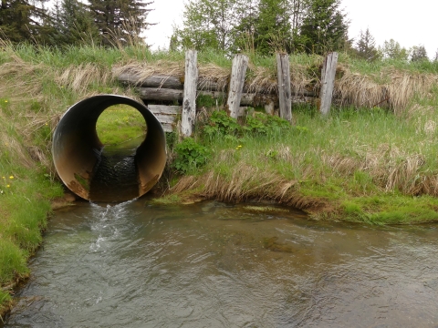
Little Tonsina River (Valdez-Cordova Borough)
Looking down the undersized double barrel culverts situated where a road crosses Alaska’s Little Tonsina River, you can get a feel for this river’s true potential—gravelly, clean, and cold. Perfect conditions for coho and Chinook salmon. If you were to follow it downstream, you’d hit the Tonsina River—a class III-IV whitewater with excellent fishing for salmon, Dolly Varden, and Arctic grayling. These waters eventually meet Alaska’s Copper River, home to what many people consider one of the world’s finest sources of salmon.
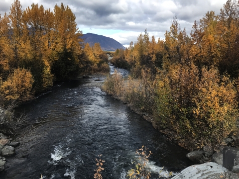
Standing on the road and looking upstream, the water is pooled, a common symptom of a fish passage fish passage
Fish passage is the ability of fish or other aquatic species to move freely throughout their life to find food, reproduce, and complete their natural migration cycles. Millions of barriers to fish passage across the country are fragmenting habitat and leading to species declines. The U.S. Fish and Wildlife Service's National Fish Passage Program is working to reconnect watersheds to benefit both wildlife and people.
Learn more about fish passage barrier and disruption of natural flow. Over 70 miles of glacier-fed salmon nursery habitats extend to the horizon.
The prospect of fitting the road with a bridge to allow the Little Tonsina to move naturally was already attracting attention and funding from multiple state and federal partners prior to 2022. Bipartisan Infrastructure Law Bipartisan Infrastructure Law
The Bipartisan Infrastructure Law (BIL) is a once-in-a-generation investment in the nation’s infrastructure and economic competitiveness. We were directly appropriated $455 million over five years in BIL funds for programs related to the President’s America the Beautiful initiative.
Learn more about Bipartisan Infrastructure Law funding in the amount of $1.3 million dollars will finally push this project to the finish line. The new funding will support the creation of a two lane 100 ft floodplain-friendly bridge that employs the Service’s comprehensive design guidelines for building road-stream crossings that provide ecological function in Alaska.
Completion of this project not only benefits the salmon of the Copper River Basin but is also expected to catalyze funding and efforts to address barriers and unstable infrastructure in nearby tributaries. As climate change climate change
Climate change includes both global warming driven by human-induced emissions of greenhouse gases and the resulting large-scale shifts in weather patterns. Though there have been previous periods of climatic change, since the mid-20th century humans have had an unprecedented impact on Earth's climate system and caused change on a global scale.
Learn more about climate change continues to disproportionately impact northern locales like Alaska, it’s important to provide salmon access to all the options when it comes to available habitat. Aquatic connectivity keeps salmon runs resilient and fisheries stable.
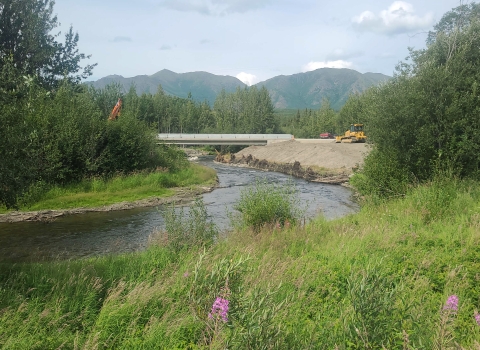
Tyonek Creek (Tyonek, Alaska)
The Native Village of Tyonek, home to many generations of Dena’ina speaking Athabascans, sits at the western side of Cook Inlet across from Anchorage. A short flight from Merrill Field past Sleeping Lady Mountain and the mouth of the Susitna River that ends on a small gravel runway will get you there.
What’s striking about Tyonek is the number of creeks you can pass over once you drive out of the community on a network of gravel roads owned and maintained by the Tyonek Native Corporation. These creeks all feed Cook Inlet, which is an incredible staging area for salmon returning to spawn in rivers, including the Kenai and Susitna watersheds, and everything in between.
Tyonek Creek is one of the largest and most important salmon streams near the village. A culvert lies less than a half mile from where the creek meets the ocean. It’s the first barrier returning salmon—particularly Coho—encounter. Undersized, and frequently clogged with debris, it is the gateway to 10 miles of upstream salmon habitat.

The U.S. Fish and Wildlife Service has been working with partners in Tyonek for many years to systematically improve fish passage where its roads cross salmon streams. These efforts benefit Cook Inlet salmon and the communities like Tyonek that depend on these fish for sustenance.
Bipartisan Infrastructure Law funding in the amount of $1.6 million will replace this last undersized culvert on Tyonek Creek with a channel-spanning bridge. Coho salmon will be able to freely access the creek, both on their upstream migration and as smolts when they make their maiden journey to sea.
The design will follow the U.S. Fish and Wildlife Service’s design guidelines to maximize ecological function while maintaining public safety and hydrologic continuity. A cost estimate and 35% engineering design have been completed for the crossing as of 2022. At the completion of this project, the Tyonek Creek watershed will be barrier free.
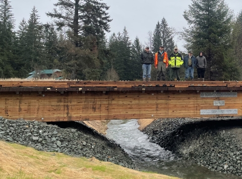
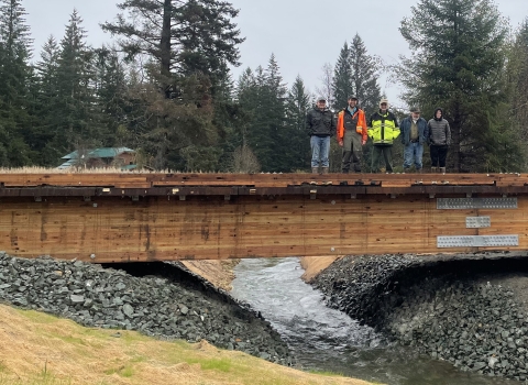
Harry Hall Creek (Gustavus, Alaska)
Gustavus is situated on the ancestral homeland of the Huna Tlingit. This community is situated in the northern part of the Southeast Alaska panhandle adjacent to Glacier Bay National Park, the Tongass National Forest, and the Alaska Marine Highway. Salmon are integral to the ecology and culture here, nourishing the streams, people, and wildlife that call this place home.
Partners including the U.S. Fish and Wildlife Service, City of Gustavus, Trout Unlimited, Alaska Sustainable Salmon Fund, and National Fish and Wildlife Foundation have been working together for many years to restore aquatic connectivity and fish passage in Gustavus via a series of culvert-to-bridge and other fish passage projects.
An undersized culvert on Harry Hall Creek at Grandpa's Farm Road is the final piece of the puzzle. Isostatic rebound, where land rises after heavy ice sheets retreat, is causing a too-small culvert to become more “perched” above the creek over time. In addition to salmon, Dolly Varden and coastal cutthroat trout use this creek.
Bipartisan Infrastructure Law funding in the amount of $600,000 allowed for the last culvert impeding fish passage to be replaced with a timber bridge. This completes the effort to reconnect the Mountain View and Flats Creek drainages to provide unimpeded access to six miles of rearing habitat for juvenile coho salmon—a very significant amount of habitat in an area of Alaska with tight topography and generally shorter river systems. It also fixes the traffic safety issue which came along with a narrow road with no guard rails, unstable banks, and a failing embankment.