About Us
Cokeville Meadows National Wildlife Refuge is a relatively new addition to the public lands of Wyoming. In 1992 the U.S. Fish and Wildlife Service completed the studies and assessments needed to fulfill NEPA (National Environmental Policy Act of 1969) requirements to start a wildlife refuge. The first land purchase from a private rancher in 1994 officially established Cokeville Meadows as a unit within the National Wildlife Refuge System. The U.S. Fish and Wildlife Service was authorized to acquire up to 27,000 acres within the Bear River Valley south of Cokeville to the Utah border. Today the refuge has grown to just under 6,500 acres of wet meadows, riparian riparian
Definition of riparian habitat or riparian areas.
Learn more about riparian area, farm ground and sagebrush sagebrush
The western United States’ sagebrush country encompasses over 175 million acres of public and private lands. The sagebrush landscape provides many benefits to our rural economies and communities, and it serves as crucial habitat for a diversity of wildlife, including the iconic greater sage-grouse and over 350 other species.
Learn more about sagebrush uplands. These acres are managed primarily for wildlife, with other uses - such as hunting, hiking, wildlife observation, interpretation, and wildlife photography being allowed as long as those uses are compatible with or help us achieve wildlife habitat goals. Another 2,800 acres are held in conservation easements, which will preserve the land as a working landscape and ensure its value as open space remain available to wildlife.
The value of the wildlife habitat provided along the Bear River through Lincoln County is top notch waterbird habitat for Wyoming. This type of shallowly flooded wet meadow and semi-permanent water habitat might not have been so extensive had it not been for the area's early settlers, who build the extensive water delivery system. Dave Lockman explained it best in his 1984 paper which assessed wetland wildlife values along the Bear River in Lincoln County, Wyoming.
“Prior to development of the water conveyance systems, it was surmised that the zone of seasonal flooding was much less than that observed today. Based on flow data from more recent years, flooding from the Bear River channel occurred for only a short time in late May through mid-June in most years. A high water table and short periods of flooding probably resulted in extensive acres of alkali flats dominated by greasewood, saltgrass, and basin wild rye.
Following the development of the conveyance systems, the period of seasonal flooding was extended from late April through early July in most normal run-off years. The extent of seasonally flooded acres was also increased to include all land between the conveyance systems and the river. Extending the period of flooding allowed the encroachment of extensive stands of native and nonnative perennial rushes and sedges and prevented the build-up of surface alkalinity. The high water table on the relatively broad and level floodplain prevented tillage and planting of domestic crops. The native rush and nonnative tame grass communities provide palatable late summer and fall forage for livestock. Today, when the river level drops by early July, ranchers stop taking water into most of the canal systems and let the water leave the flooded acres largely through evapo-transpiration. By mid- to late July and early August haying equipment is moved onto the extensive seasonally flooded acreages and the forage is harvested for winter livestock feed. In most years about 70% of the seasonally flooded acres become dry enough to harvest for hay. The canal systems have a relatively level gradient and hold water into the fall and, in some areas, year long. Therefore, the semi-permanent water conditions in the canals and associated impounded areas are conducive to the development of tall emergent communities, and open water areas produce luxurious growth of rooted aquatic vegetation. Livestock graze some of the cut emergent communities in the fall/winter; however, some years many of the acres are reflooded in the fall.”
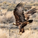
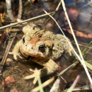
The habitat around the Bear River south of Cokeville was greatly improved for water birds because of the irrigation infrastructure the local farmers and ranchers built in the 1880s and early 1900s to effectively move water across the flat open valley. This type of irrigation, called flood irrigation, provides ideal feeding and nesting habitat for many water birds. The shallowly flooded meadows and farmed small grains and alfalfa provide important food for migrating birds - especially waterfowl and Sandhill cranes during their flights north in the spring and south in the fall. During the late spring and early summer, the large expanses of wetlands provide ideal areas for secretive marsh birds (such as the American bittern, sora, Virginia rail and pied-billed grebe) and colonial nesting birds (like Franklin's gulls, black terns, white-faced ibis and black-crowned night herons) to build nests and raise their young. Many other waterbirds such as ducks, geese, coots, cranes and great blue herons call the meadows home as well, more than 70 species. Pronghorn antelope, elk, deer and the occasional moose can often be seen in the valley too.
Our Mission
The mission of the National Wildlife Refuge System is to administer a national network of lands and waters for the conservation, management and, where appropriate, restoration of the fish, wildlife and plant resources and their habitats within the United States for the benefit of present and future generations of Americans.
Our History
Area’s General History
The Bear River Valley south of Cokeville, WY has a long, rich history. Up to the 1860s, the area was primarily used by the Northern Shoshone Indians, mostly bands from the Snake and Bannock Shoshone Tribes as they seasonally hunted and gathered food (Lloyd, 1970.) The Snake Tribes had horses as of the early 17th century and roved the area hunting buffalo and large game to supplement their hunting/gathering culture. Small war parties and bands of Crows and Blackfeet from the north and east frequently roamed through the region around the time white man arrived in the early 1800s. Various fur trappers and early explorers roamed the area during 1820s-1840s, including the notable Jim Bridger, Osborne Russell, Jedediah Smith, and others; later in the 1840s wagon trains and emigrants began passing through the area. The first settlement in the Cokeville vicinity was recorded in 1872 and by the 1877 census, 55 adults and 62 children were living in the Cokeville area, between Sublet Creek and Cokeville. In June of 1882 the railroad reached Cokeville from Evanston and continued north to the Idaho border. Electricity made its debut in 1917 in the Cokeville area.
The earliest water rights from the area around the refuge were filed for in 1877, when the locals likely began their ongoing efforts to create irrigated crop ground through a network of ditches, dikes, levees and dams that still persist and are in use today throughout much of the valley. Because of the extensive network of ditches, dikes and diversions through the valley many acres of drier greasewood flats or sagebrush sagebrush
The western United States’ sagebrush country encompasses over 175 million acres of public and private lands. The sagebrush landscape provides many benefits to our rural economies and communities, and it serves as crucial habitat for a diversity of wildlife, including the iconic greater sage-grouse and over 350 other species.
Learn more about sagebrush uplands have been converted to wet meadows which provide excellent waterbird habitat as well as livestock forage. Much of the drier areas on the periphery of the large meadows, on the surrounding foothills are used for alfalfa and cereal grains, barley, oats and some wheat. The vast meadow regions along the Bear River valley bottom provide highly productive grass hay. Ranchers have ran sheep and cattle in the area for over a hundred years.
Sources:
Llyod, Errol Jack. 1970. The History of Cokeville, Wyoming – thesis for Master of Science in History. Utah State University Logan, Utah.
Noblitt, Jack. 1955. The History of Cokeville, Wyoming – English Research Paper. Laramie, Wyoming.
Russell, Osborne. Journal of a Trapper.
Other Facilities in this Complex
Cokeville Meadows National Wildlife Refuge is managed as part of the Central Sage Steppe Conservation Complex. A Conservation Complex is an administrative grouping of two or more refuges, wildlife management areas or Conservation Areas that are primarily managed from a central office location. Refuges are grouped into a complex structure because they occur in a similar ecological region, such as a watershed or specific habitat type, and have a related purpose and management needs. Typically, a project leader or complex manager oversees the general management of all refuges within the complex and refuge managers are responsible for operations at specific refuges. Supporting staff, composed of administrative, law enforcement, refuge manager, biological, fire, visitor services, and maintenance professionals, are centrally located and support all refuges within the complex.