


Trails
Baskett Slough NWR has both year-round and seasonal trails. Seasonal trails are specified in their description and are open from April 1st - September 30
Download Our Trails Brochure: Trail Descriptions Baskett Slough NWR
Here is a refuge map to help you find trailheads and other viewing spots! Baskett Slough NWR Map
Visit our homepage to view any current alerts, including trail closures.
Please note, dogs are not allowed on any refuge trails.
Trails, Viewpoints & Boardwalks
Trail | Image and/or Video | Description | Additional Information |
Rich Guadagno Memorial Trail(Year-round) | Trailhead location: The Rich Gudadagno trailhead parking area is located just off Coville Road in the middle of the refuge.Trail Description: Learn about the legacy of Rich Guadagno and be rewarded with 360 views from the overlook platform. At the platform you will get a great view of the many wetlands that encompass the southern part of the refuge. In the winter, you can see thousands of migratory waterfowl using the wetlands. Restrooms are available at the trailhead near the parking lot. Check out the eBird Hotspot to know which birds are being recorded at the trail. |
| |
Morgan Lake Trail(Seasonal - April 1 to Sept 30) | Trailhead location: From Pacific Highway West, turn onto Smithfield Road and continue straight for 2 miles. This out and back trail starts at a parking area located at the junction of Smithfield and Livermore Road on the north side of the refuge.Trail description: Walk to Morgan Lake, where you can spot Canada geese, Mallards, and Cinnamon Teal. Listen for Red-winged Blackbirds and Marsh Wrens. Check out the eBird Hotspot to know which birds are being recorded at the trail. Enjoy views of the Refuge, then choose to return or connect to other trails. |
| |
Baskett Butte Loop Trail(Year-round) | Trailhead location: Start this trail by hiking the Rich Guadagno Trail. Walk up the hill – take a right at the fork to begin the loop trail.Trail description: This trail loops through oak woodlands and mixed forest. In the spring this trail is great for viewing migratory songbirds. |
| |
Highway 22 Wildlife Viewing Kiosk(Year-round) | Viewpoint location: Access viewpoint 2.5 miles west of Highway 22/99W Intersection.Viewpoint description: Stop at this scenic kiosk to enjoy views of Baskett Slough’s wetlands and green hillsides. This kiosk is a |
|
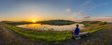

Highway 22 Wildlife Viewing Kiosk
Location:2.5 miles west of Highway 22/99W Intersection
Open: Year Round
Viewpoint description: Stop at this scenic kiosk to enjoy views of Baskett Slough’s wetlands and green hillsides. This kiosk is a
great place to stop to view the hundreds of migrating waterfowl that use the wetlands of Baskett Slough National Wildlife Refuge. Look for herons, shorebirds, coyotes wandering across the fields, and more! Explore the interpretive signs to learn more about the refuge’s amazing wildlife, history of the Willamette Valley National Wildlife Refuge Complex, and more.
Baskett Butte Loop Trail
Distance: 1.5 miles round trip
Open: Year Round
Difficulty: Easy
Type of trail: Loop
Trailhead location: Start this trail by hiking the Rich Guadagno Trail. Walk up the hill – take a right at the fork to begin the loop trail.
Trail description: This trail loops through oak woodlands and mixed forest. In the spring this trail is great for viewing migratory songbirds.
Listen for Spotted Towhees, Ruby-crowned Kinglets and Bewick’s wrens as you hike through the woodlands. This trail is also home to wintering songbirds and woodpeckers like Acorn Woodpeckers and rare wildflowers like the Kincaid's Lupine.
Morgan Lake Trail
Distance: 1.7 miles one way
Open: April 1 - Sept 30
Difficulty: Easy
Type of Trail: Out and Back
Trailhead location: From Pacific Highway West, turn onto Smithfield Road and continue straight for 2 miles. This out and back trail starts at a parking area located at the junction of Smithfield and Livermore Road on the north side of the refuge.
Trail description: Walk to Morgan Lake, where you can spot Canada geese, Mallards, and Cinnamon Teal. Listen for Red-winged Blackbirds and Marsh Wrens. Enjoy views of the Refuge, then choose to return or connect to other trails.
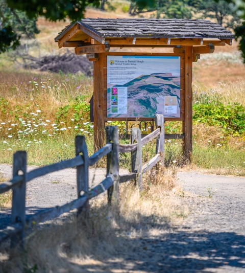
Rich Guadagno Memorial Trail
Distance: 0.4 miles one way
Open: Year Round
Difficulty: Easy with moderate uphill
Type of Trail: Out and Back
Trailhead location: The Rich Gudadagno trailhead parking area is located just off Coville Road in the middle of the refuge.
Trail Description: Learn about the legacy of Rich Guadagno and be rewarded with 360 views from the overlook platform. At the platform you will get a great view of the many wetlands that encompass the southern part of the refuge. In the winter, you can see thousands of migratory waterfowl using the wetlands. Restrooms are available at the trailhead near the parking lot.