What We Do
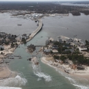
Our primary responsibilities under the Coastal Barrier Resources Act (CBRA) include maintaining the official maps of the John H. Chafee Coastal Barrier Resources System (CBRS) and making recommendations to Congress for appropriate changes to the boundaries; consulting with federal agencies regarding federally funded projects proposed within the CBRS, and determining whether properties are located “in” or “out” of the CBRS.
We maintain a CBRS Mapper that makes the official maps and boundary data more accessible to property owners, project proponents, and other stakeholders who need to know whether properties or project sites may be affected by CBRA.
We also provide a self-serve CBRS Validation Tool within the mapper for the public and other federal agencies to (in most cases) make a determination as to whether individual properties are located within the CBRS, which is important for the issuance of flood insurance policies, real estate transactions, and federal expenditures within the CBRS.
Ensuring that CBRS maps are updated, usable, and accurately depict CBRS boundaries are important goals of the Service. We are committed to modernizing the CBRS maps using digital technology to improve access to information, increase efficiency for infrastructure project planning, and increase accuracy and timeliness in determining whether individual properties are located with the CBRS. As of November 2024, we have prepared and Congress has adopted modernized maps for more than half of the CBRS units, comprising 36 percent of the CBRS acreage. These modernized maps will help conserve natural resources and save taxpayer dollars by ensuring that federal funding for development activities is not provided in error within the CBRS. This work also allows us to correct any technical mapping errors that may negatively affect property owners and expand the CBRS to include eligible undeveloped land and associated aquatic habitat.
View official CBRS maps.
Find answers to frequently asked questions about our work and the Coastal Barrier Resources Act.
Our Services
Property Documentation
Within the CBRS, most new federal expenditures and financial assistance, including flood insurance through the Federal Emergency Management Agency’s National Flood Insurance Program, are prohibited. Federal agencies may require documentation indicating whether or not a property or project site is within the CBRS before they approve federal funding or financial assistance in areas that contain CBRS units. The Service provides two ways for federal agencies and others to obtain such documentation: the CBRS Validation Tool and CBRS Property Determinations.
Learn more about property documentation.
Project Consultations
Prior to making federal expenditures or financial assistance available within a System Unit of the CBRS, federal agencies must request consultation with the Service to determine whether the project or activity is allowable under CBRA. Following this consultation, federal agencies may make federal expenditures and financial assistance available within CBRS units for activities that meet one of the exceptions under CBRA.
Learn more about Coastal Barrier Resource Act project consultations.
Boundary Modifications
Congress designated the initial CBRS units in 1982 and modified and expanded the CBRS in 1990. When technical mapping errors are found, Congress works with the Service to comprehensively revise the CBRS boundaries and enact technical correction legislation to adopt the revised CBRS map. Property owners and other interested parties may submit a request to remove land from the CBRS if that land was originally included in error.
Learn more about requests for boundary modifications.
Our Projects and Research
The Coastal Barrier Resources Reauthorization Act of 2005 (Pub. L. 109-226) directed us to: (1) finalize a digital mapping pilot project that includes draft revised maps for approximately 10 percent of the entire CBRS and an accompanying report to Congress, and (2) create draft revised maps for the remainder of the CBRS. To date, we have prepared, and Congress has enacted into law, comprehensively modernized maps for about 36 percent of the CBRS acreage. Learn more about historical changes to the CBRS.
The mapping projects listed below make progress toward either fulfilling the mandates in Pub. L. 109-226 or our statutory 5-year review requirement. Maps produced through our comprehensive remapping efforts must be enacted by Congress to become effective, while maps produced through the 5-year review process make only minor modifications and are made effective administratively through publication of a notice in the Federal Register. Learn more about the CBRS boundary modification process.