

Written By

Sunbury, Georgia – For millennia, the salt marsh salt marsh
Salt marshes are found in tidal areas near the coast, where freshwater mixes with saltwater.
Learn more about salt marsh has protected the Georgia coast from bad storms while nourishing oysters, blue crabs, sea turtles, and the aptly named saltmarsh sparrows. The muddy, peat-y, cordgrass-filled wetlands provide a natural bulwark against rising seas by buffering the waves that erode shorelines.
At least they’re supposed to.
Increasingly, the marshes are disappearing. Rising seas force them to move further and further inland. Yet seawalls, roads and condos leave little room for the marshes to migrate. Meanwhile, with roots continuously submerged, the cordgrass drowns.
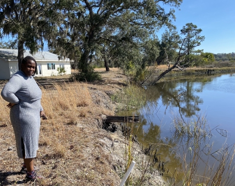
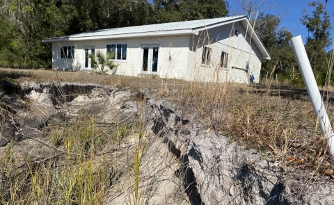
The damage is all too apparent at the Martha Randolph Stevens Park, one of Georgia’s few coastal enclaves where descendants of the formerly enslaved were deeded a slice of the salt marsh.
“This happened so fast,” said Aminata Traore, an environmental justice advocate, while overlooking the crumbling bluff buffeted by the high-tide creek that leads to the North Newport River. “The erosion is, steadily, coming closer and closer to our building.”
The park’s community center sits barely 20 feet from the latest cleaved-off embankment, yet it might just survive. Much money, and long overdue attention, is coming to the salt marshes that line the Atlantic Coast from North Carolina to Florida. Stevens Park has already received $116,000 from the National Fish and Wildlife Foundation to design a “living shoreline” to keep the rising tides at bay.
The latest round of conservation projects was recently rolled out and nearby Harris Neck National Wildlife Refuge will receive a half-million dollars to help fix erosion. The administration's Salt Marsh Keystone Initiative is synced nicely with another region-wide plan: the South Atlantic Salt Marsh Initiative, or SASMI.
SASMI began three years ago as a partnership between the Pew Charitable Trusts and the Southeast Regional Partnership for Planning and Sustainability, or SERPPAS. Today, dozens of local, state, federal, military, and nonprofit organizations work together to protect the coast from rising tides and rampant development. SASMI's goal is to restore, or help migrate, one million acres of salt marsh along the Atlantic Coast in the Carolinas, Georgia, and the northern half of the Florida peninsula. SASMI has come up with dozens of marsh restoration projects, including Stevens Park which seeks an additional $500,000 to rebuild its shoreline.
“There’s some urgency now because we’re facing threats from both sides – from the sea with rising water and from the land with encroaching development,” said Courtney Reich, the coastal director for the Georgia Conservancy who’s charged with implementing SASMI in the Peach State. “We’re squeezing out the salt marsh. It’s a beautiful place. A lot of people want to move here. Thankfully, the economy is booming. But we have to be thoughtful now where we want to preserve and conserve our coast.”
Rising seas, disappearing marshes
A tidal gauge nestled inside a wooden shack at the end of a pier next to the Fort Pulaski Pulaski
The Pulaski is a special hand tool used in wildland firefighting. The tool combines an axe and an adze in one head, similar to that of the cutter mattock, with a rigid handle of wood, plastic, or fiberglass. The Pulaski is a versatile tool for constructing firebreaks, as it can be used to both dig soil and chop wood.
Learn more about Pulaski National Monument has measured sea levels since 1935. Its recordings are, increasingly, alarming. The seas off coastal Georgia have risen nearly a foot since then and, according to the National Oceanic and Atmospheric Administration, will likely keep rising one inch every two years.
By 2110, the coast could lose eight percent of its undeveloped dry land.
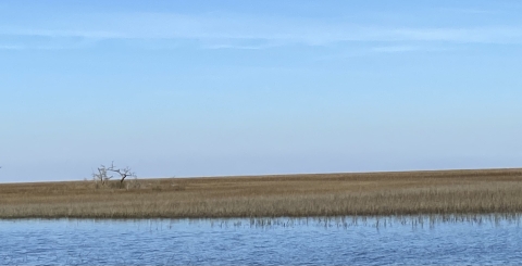
Meanwhile, many of Georgia’s 368,000 acres of salt marsh will disappear under the waves. NOAA estimates that as much as a third of the tidal wetlands along the South Atlantic could be lost by 2060 due to sea level rise alone. Gone, too, would be the plants, algae, and decaying matter that form the food web for so many species. Marshes and estuaries provide shelter, nourishment, and nurseries for three-fourths of the nation’s commercial and recreational aquatic species, including white shrimp, blue crabs, redfish, and flounder.
Resident and migratory birds feed and nest among grasses, mud flats, and pools. Ducks overwinter in the spartina alterniflora. Populations of saltmarsh sparrows, which spend their entire lives along the East Coast, have declined 70 percent due to rising seas and drowning marshes. And good luck finding the elusive, sparrow-sized, and federally threatened eastern black rail.
“To my knowledge,” said Morgan Wolf, the U.S. Fish and Wildlife Service’s primary black rail biologist, “there have been no detections on the Georgia coast, or interior for that matter, within the last decade or so despite significant survey effort.”
'Really been eaten away’
Permanently inundated mudflats can't fight the very climatic forces – greenhouse gases – that ruin the climate in the first place. The marshy ground is composed of muddy sediment and decomposing plant matter, otherwise known as peat. Peat stores carbon at a rate up to 50 times greater than terrestrial forests – a critical weapon in the fight against global warming.
Protecting peatlands is critical to meet the goal of cutting greenhouse gas emissions in half by 2030. Georgia plays an outsized role in carbon sequestration. Its hundred-mile-long coastline acts as a “blue carbon” sink keeping the greenhouse gas in the ground.
Yet that ribbon of carbon-storing salt marsh is disappearing. The damage is perhaps most visible to the public at the dock and boat ramp at the Harris Neck refuge.
“It’s really been eaten away the last couple of years,” said Loyd Deverger, a commercial crabber for nearly half a century, after pulling pots from the Barbour River one recent blue-sky afternoon. “It cuts farther and farther, and deeper and deeper, on the edge.”
The refuge will use $511,530 to build an 800-foot-long “living shoreline” of oyster shells, native plants, and all-natural logs on either side of the dock, ramp, and a nearby commercial crabbers’ dock. Yet the project’s significance goes well beyond shoreline protection. Both salt marsh initiatives are intended to boost recreational and commercial activities like boating, fishing, and bird watching. Historical, cultural, and archaeological attributes are also important.
Harris Neck fits the bill on all accounts. Native Americans, including the Guale Indians, lived in villages and traded along the Georgia coast for centuries. The formerly enslaved Gullah Geechee people, and other Black and white families, farmed and fished at Harris Neck from the Civil War’s end to 1942 when the federal government condemned and bought their land for a military airbase.
After World War II, the properties were turned over to McIntosh County. Twenty years later the land became a wildlife refuge, a haven for wood storks, painted buntings, and migratory birds. In 2020, the African American descendants of the Harris Neck community, after years of relationship-building, signed a memorandum of understanding with the Service to collaborate on projects.
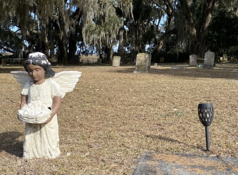
The living shoreline will also protect Gould Cemetery, an African American graveyard along the Barbour River that dates to 1882 and sits shrouded in live oaks, magnolias, palmetto bushes, and Spanish moss. The high tide rack line, though, creeps ever closer to the cemetery’s edge. Large, twisted oaks, their roots exposed, hang precariously low over the encroaching tides. The project is also designed to protect the nearby “baptismal tree,” a magnificent, yet threatened oak which designates the spot where baptisms were held.
'Respect for the land’
The most recent round of financing also included $1.4 million to replace a boardwalk along the Scuppernong River in North Carolina and $450,000 to create the Georgia Native Seed Network. Cape Romain National Wildlife Refuge in South Carolina – the poster child for sea-level damage – gets $100,000 to determine whether dredged sand can be used to rebuild a barrier island.
SASMI, the other saltwater initiative, takes a broader approach to coastal restoration with each of the four states listing a slew of projects in search of funding. It’s modeled loosely on America’s Longleaf Restoration Initiative, a state-federal-nonprofit partnership to conserve and re-grow longleaf pine forests that once covered 90 million acres from the Mid-Atlantic to Texas. Both initiatives also grew out of collaboration with SERPPAS to buffer and conserve lands surrounding the many military installations across the Southeast.
Through the Inflation Reduction Act, $575 million will go out nationwide to boost the resilience of coastal communities to extreme weather, sea level rise, and other climate-induced dangers. The Georgia Conservancy lists nine projects, from Savannah to St. Marys, worthy of federal, state, or nonprofit funding, including Harris Neck.
Wetlands in downtown St. Marys would also be bought up and turned into a community green space for migrating salt marsh. In Brunswick, living shorelines would be built to buffer two historic cemeteries. On Tybee Island, a culvert would be replaced to allow the tides to better nourish a nearby salt marsh. And, near Sunbury, a 400-foot-long living shoreline would save the community building at the Martha Randolph Stevens Park.
“That’s where I learned to go crabbing, fishing, shrimping, oystering, and it was my first exposure to wildlife in its natural habitat,” said Krystal Hart, president of the foundation that manages the park and nearby Seabrook Village. “I just took it for granted that I always had access to the water, that it was a part of the community, something special, a safe haven.”
Vandals, though, came by boat to “Stevens Landing” to break windows, steal the septic tank, and write racist graffiti on the community center’s walls because, as Hart says, they thought African Americans were “not deserving of it.” The foundation couldn’t afford to fix up the park after each crime. It has mostly sat vacant since 2005.
Two years ago, though, interest in restoring the park and community center – and rapidly disappearing bluff -- was rekindled.
“Hopefully,” Hart said, “this will help younger generations to have respect for the land, the environment, and the waterways as a source for food, enjoyment, and a way of life.”


