

Written By

Did you know that many national wildlife refuges across the nation are open to cyclists? Refuges offer open roads, beautiful vistas, and opportunities to see diverse wildlife in their natural habitat. Skip the crowds at more well-known places and find plentiful parking, bathrooms, and friendly staff at a refuge near you.
We talked to local cyclists who gave us their favorite routes in and around refuges. They gave us insider knowledge on road conditions, places of interest along the way, and the best time of year to complete the ride. If you go, post your photos and tag @usfws or use the hashtag #ridetherefuge. We’d love to see your adventure! Make sure you check the refuge website before you go to make sure roads are open to cyclists.
Ash Meadows National Wildlife Refuge
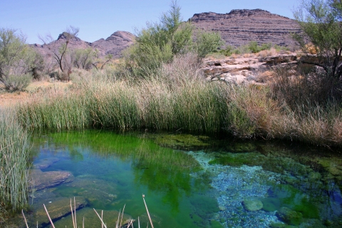
Ash Meadows National Wildlife Refuge is about 90 minutes west of Las Vegas and sits on the California-Nevada border just east of Death Valley National Park. Off the beaten path, the refuge is a true desert oasis. Its isolated location has given rise to nearly 30 species of plants and animals that are found only there, including the endangered Devils Hole pupfish and the Amargosa pupfish, which call the warm, freshwater springs home. The refuge is also home to Crystal Spring, which produces 2,800 gallons of freshwater a minute.
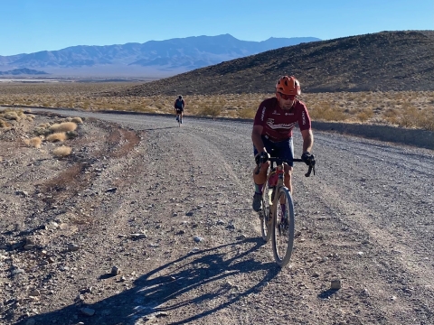
We talked to Mark Duncan and Nathan Grill, co-founders of the cyclocross team, Team Hammersaw. Both are lifelong, avid cyclists who enjoy introducing other riders to some of the best roads and routes in the Las Vegas area. One of their group rides takes new and advanced dirt enthusiasts to Ash Meadows.
The basics:
- Start: Crystal, Nevada
- Route type: Mountain or gravel bikes; not suitable for road bikes
- Distance: 40 miles, out and back (download the Strava route here)
- Skill level: Advanced beginner to advanced. Not a good route for children due to distance
- Elevation gain: Approximately 1,000 feet in elevation gain
- Time of year: October to April
- Essential supplies: Food, water, repair supplies, face mask (all federal properties require them)
- Nice to have: Binoculars
- Other things to know: Cellphone reception is spotty, and traffic is minimal. Come prepared and tell a friend where you’re going
Before you go:
- Check the refuge's website to make sure it’s open to cyclists. Many refuges only allow cyclists in certain areas such as public access roads and others only at certain times of the year to minimize disturbance to wildlife. You can find a refuge near you on the Service's national website.
- Bring a mask. National wildlife refuges are federal lands which require mask usage when you’re within 6 feet of other people or in federal buildings (bathrooms and water stations included).
- Refuge riding is often rural riding. Ride at your own risk, and ride with a buddy. Many of the roads at refuges are unpaved and have very little traffic. Bring plenty of supplies to repair flats and get back to your vehicle safely.
The ride:
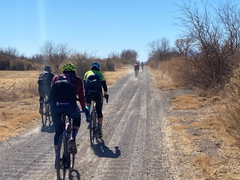
The group started in the small town of Crystal, Nevada, due to its proximity to Devils Hole Road, the main road to the refuge. If you need to fuel up with gas, water and snacks, stop in Pahrump, Nevada (about 30 minutes away). There are no stores in Crystal.
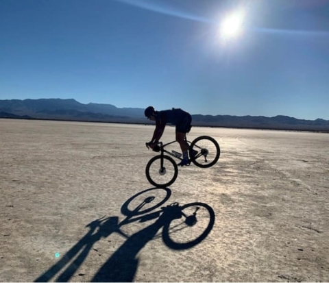
Starting on Devils Hole Road, you’ll have about a half-mile of pavement before hitting dirt. Grill describes it as a well-maintained road. As you make your way west, you’ll pass a picturesque dry lakebed on the left. It’s the perfect location for snapping an awesome landscape photo or that cycling profile picture you’ve always wanted. Soon after, the road transitions from well-maintained to washboard and a gentle climb begins.
“The road and climb are very manageable, but there’s some loose, deep sand,” suggests Grill. “Pay attention, and choose your lines carefully.”
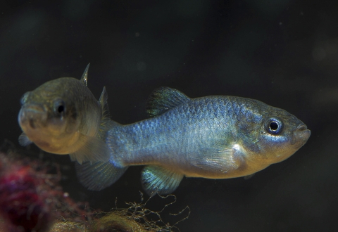
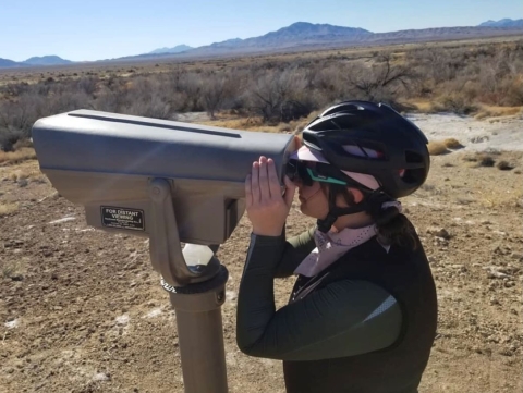
About 10 miles in, you’ll find a chain link fence surrounding the famous Devils Hole, a freshwater-filled cavern that’s more than 500 feet deep. Leave the bikes below and climb up to the metal walkway to look at the cavern. If you happen to have binoculars, you might be able to spot the tiny Devils Hole pupfish, an iridescent blue, inch-long fish known to live only in the 93-degree waters of Devils Hole.
“The pupfish has lived there for thousands of years in an untouched environment,” says Duncan. “There are videos of the hole shaking when earthquakes in Mexico hit.”
After seeing the pupfish, get back on the bike and cross into the refuge. Here, the road transitions back to well-maintained gravel. Another 5 miles down the road, you’ll find a trail head to the Point of Rocks Spring Trail. In addition to having a bathroom, there’s a boardwalk that will take you to a lookout where you can have a snack while looking at birds and Kings Pool, a crystal-clear freshwater spring. Trails and boardwalks in the refuge are for walking only. Cyclists should secure their bikes near the trailhead or at parking areas.
“You can see endangered Amargosa pupfish swimming in the spring, and depending on the time of year, you can also see a lot of birds,” says Duncan.
Point of Rocks Spring Trail is about three miles from the Ash Meadows National Wildlife Refuge Visitor Center. If you need to cool off, put on your mask, and take a peek at the exhibits inside the Visitor Center, which is currently open Saturdays and Sundays from 10:00 a.m. to 3:00 p.m. The bathrooms are also open.
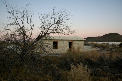
From the Visitor Center, take a right on Longstreet Spring Road to go out to the old, stone cabin built by Jack Longstreet in 1896. The cabin is a reminder of the long history of the refuge, from the Southern Paiute who still call this area home to the white settlers who chose Ash Meadows for its unique access to water. Again, secure your bikes and walk down the path to check out the cabin.
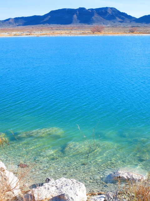
At this point you’re halfway through the ride. Head west on Peterson Reservoir Road and follow the bend south to cruise past Peterson Reservoir which is hidden by reeds. Take a left on Spring Meadow Road and a right on Horseshoe Marsh Loop to ride past Crystal Reservoir (about 28 miles into the ride route). The turquoise blue water sits in sharp contrast to the white and yellow desert hills that dominate the landscape.
Turn right on Spring Meadows Road, and head east back to the starting point. Duncan says that the ride back to the start goes a little faster since you’ve already stopped at the points of interest along the way.
“The refuge is like a jewel in the desert,” says Duncan. “It’s a beautiful place in this inhospitable landscape. It’s really special.”


