Written By

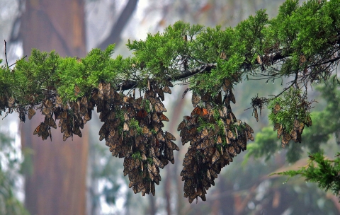
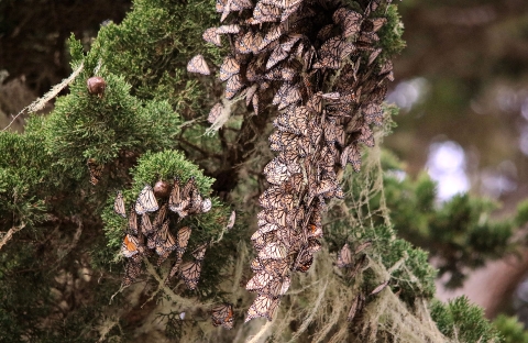
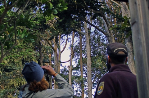
Every year, monarchs from as far away as Idaho, Utah, Arizona and other Western states converge to spend the winter in tree groves along the Pacific coast and at a few inland sites. Following the butterflies’ arrival, citizen scientists trek to these coastal overwintering sites, from Mendocino County, California to northern Baja California, Mexico to count the butterflies.
The gathering of monarchs in select areas provides a unique opportunity to gauge the health of the population in the West. These volunteers must rise early, when dew decorates the landscape and morning light breaks along the horizon, in order to accurately assess monarch numbers before the sunlight warms their wings and they flutter off in search of nectar or water.
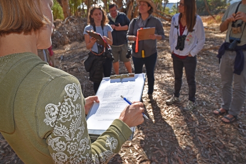
Citizen scientists are the backbone of the Western Monarch Thanksgiving count. They are led by The Xerces Society for Invertebrate Conservation and Mia Monroe, a founder of the original Thanksgiving count scheduled around Thanksgiving each year. The coordinated effort began in 1997 to better understand year-to-year changes in monarch butterfly populations in the West.
Inspired by trees draped in orange and black, Monroe and others, standardized a method for estimating overwintering populations.
To summarize the monitoring method, volunteers start by counting a portion of a cluster, and then use that number to estimate the size of the remainder of the larger cluster. Xerces Society offers a Western Monarch Thanksgiving Count training and can connect interested individuals with a local, seasoned volunteer in their area.
Since its inception, experts have used the data to estimate the annual population of monarchs in the West. The 2017 count tallied 192,629 monarchs. This is the lowest number observed since 2012, and was notably down from 2016 when slightly fewer than 300,000 overwintering butterflies were estimated along the California coast.
A few sites in Santa Cruz County remained stable or were slightly higher in numbers in 2017, however, in some of the largest overwintering sites, population numbers decreased dramatically. The severe decline in monarch overwintering numbers is clear: 20 years ago, when the Thanksgiving count began, approximately 1.2 million monarchs were estimated at overwintering groves along the coast.
This data, made possible only through the efforts of dedicated volunteers, is currently the only technique used for estimating monarch populations. But not for long; researchers are now testing a high-tech method, which would lead to increasingly accurate and expedient population estimates. A scientific surveying tool is being tested for the first time to help us gather increasingly accurate and expedient estimates for large overwintering sites in the West.
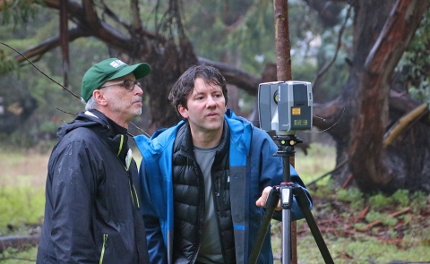
A group of researchers from the U.S. Fish and Wildlife Service, Winston-Salem State University in North Carolina and the U.S. Geological Survey are testing a new method for estimating monarch populations that could bring increased precision to the current process.

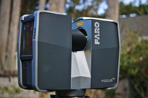
The technique uses a system called Light Detection and Ranging, otherwise known as LiDAR. First developed in the 1960s, LiDAR is a remote sensing technology that uses light in the form of a pulsed laser to measure distances to the earth and is commonly used to map topography, generating three dimensional information about surface characteristics.
But how can this remote sensing tool be used to “map” monarchs?
LiDAR has proven to be an effective tool for estimating hibernating gray bat populations, a species that exhibits dense-clustering patterns comparable to overwintering monarchs.
Dr. Nick Hristov and Dr. Louise Allen of Winston-Salem State University pioneered the use of LiDAR to estimate wildlife populations, almost by mistake.
“We began using terrestrial-based LiDAR to study the morphology of caves used by roosting bats, only to realize that we were missing an opportunity by not including the bats in our analyses - after all, bats were really just an extension of the cave morphology when roosting in there,” said Hristov. “The technology is uniquely suited for capturing rich three-dimensional data, quickly and very accurately."
"Such applications have allowed us to learn more about not only the number of roosting bats but also where in the caves bats roost, what they do when they are in there, when they move, how they structure structure
Something temporarily or permanently constructed, built, or placed; and constructed of natural or manufactured parts including, but not limited to, a building, shed, cabin, porch, bridge, walkway, stair steps, sign, landing, platform, dock, rack, fence, telecommunication device, antennae, fish cleaning table, satellite dish/mount, or well head.
Learn more about structure their roost formations, etc.,” he said.
Hristov admits that although using LiDAR to assess the size of overwintering monarch clusters will be considerably more complicated than with roosting bats. “We hope, with further developments of the associated technologies, to be able to gain new insights about this fascinating species and how best to support its conservation.”
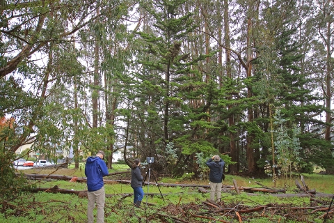
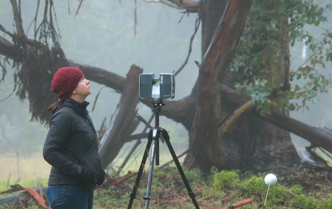
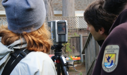
In December 2015, Hristov, Allen and Ryan Drum, lead Service biologist on the Monarch Science Conservation Partnership, visited three key overwintering sites in California - Pacific Grove, Lighthouse Field and Pismo Beach – where monarchs were clustered to test the LiDAR concept to map the butterflies and the groves they occupy.
Overwintering sites are scanned with the LiDAR device twice to gather an accurate assessment of monarch density: once while monarchs are present, and once after dispersal from overwintering sites. By mapping surface area with and without monarchs, it may be possible to produce precise estimates of overwintering colonies. The mapping images captured by LiDAR can then be compared for density.
Use of the technology to measure monarch population numbers is in the early stages of testing, and researchers say if it works, the results would be transferable. Researchers hope for a combined survey approach, in which citizen scientists would continue to monitor Western overwintering sites, while supplementing hand-counts with LiDAR technology at larger overwintering areas. The technology would also be used to estimate the famous monarch clusters in central Mexico.
“Our partners in California and Mexico play an important role in monitoring the monarch population each year. The data serves as the basis for our understanding of the monarch’s extinction risk and helps to inform habitat goals across North America,” said Drum. “New technologies are empowering us to test key assumptions about overwintering numbers and can help improve the accuracy of our population estimates in ways that we hope can also help conservation efforts for bats, monarchs, and other species.”
Because it is a mapping technology, LiDAR will create 3-D maps of the overwintering sites to help the Service track the quality of overwintering habitat in California, and eventually Mexico, from year-to-year.
LiDAR could make all the difference for monarchs and our understanding of their population. It could bring precision and accuracy to the science of estimating monarchs and change the best available science as we know it.