Location and Contact Information
About Us
Waubay National Wildlife Refuge, located in northeastern South Dakota, was established in 1935 as a refuge and breeding ground for migratory birds and other wildlife. It is administered by the Department of the Interior's U.S. Fish and Wildlife Service. At the time Waubay was established, the center of the country was in the midst of a devastating drought that affected not just people and crops, but decimated waterfowl populations. Today, the National Wildlife Refuge system has grown to more than 566 Refuges located in all fifty states. It is the largest system of lands in the world dedicated to preserving fish, wildlife, and their habitats.
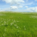
The Refuge includes 4,650 acres of lakes, marshes, grasslands, and woodlands which support diverse and abundant wildlife. The name Waubay comes from the Dakota word "wabe" meaning a waterfowl nesting place. There couldn't be a better name for this National Wildlife Refuge, where 245 species of birds have been observed. Both eastern and western bird species of the United States can be found here. Waubay is also at the southern end of the breeding range of red-necked grebes and LeConte's sparrows and at the northern edge of red-bellied woodpeckers, northern cardinals and yellow-billed cuckoos.
Water levels in prairie lakes, like Waubay Lake, are subject to extreme fluctuations. In the 1930's, Waubay Lake was dry. Heavy precipitation between 1993 and 1997 caused the lake level to rise 15 feet, flooding 100 year old trees.
When water levels change, wildlife using the refuge changes. Low water periods draw thousands of diving ducks attracted to sago pondweed beds. On the other hand, flooded timber makes ideal habitat for nesting wood ducks. More than 100 species of birds nest on the Refuge; their relative abundance adjusting with changes in habitat.
What We Do
Resource Management
The main goals for habitat and wildlife management set forth in the Comprehensive Conservation Plan for Waubay Complex are:
- Habitat Goal: To preserve, restore, and enhance the ecological diversity of grasslands, wetlands, and native woodlands of the Prairie Pothole Region of the Great Plains on Waubay National Wildlife Refuge Complex.
- Wildlife Goal: To promote a natural diversity and abundance of native flora and fauna of the Prairie Pothole Region.
These goals are achieved using a variety of tools and techniques some of which include grazing, prescribed burning, restoration, haying, weed management, and rest when appropriate. We are constantly striving to maintain or improve refuge lands for the benefit of the wildlife that need these habitats. Many factors complicate the work including surrounding habitat (or lack of), size of tract, insufficient science or data, local weather conditions, as well as climate and landscape changes.
Standardized ground and aerial wildlife surveys and vegetation surveys are conducted on some waterfowl production areas throughout the year to inventory populations and document habitat use. Units are evaluated by how well they meet habitat and wildlife use objectives. Additional surveys are conducted that contribute to larger landscape or national informational needs such as the spring waterfowl breeding surveys or Breeding Bird Surveys. We are constantly striving to fulfill our mission to "conserve, protect, and enhance fish, wildlife, plants, and their habitats for the continuing benefit of the American people."
Public involvement and input are important to us and to the planning process, and we hope you will take an active interest in the process, individually and as a community.
Conservation
- National Wildlife Refuge System Improvement Act of 1997: The National Wildlife Refuge System Improvement Act defines a unifying mission for all refuges, including a process for determining compatible uses on refuges, and requiring that each refuge be managed according to a CCP. The NWRS Improvement Act expressly states that wildlife conservation is the priority of System lands and that the Secretary shall ensure that the biological integrity, diversity, and environmental health of refuge lands are maintained. Each refuge must be managed to fulfill the specific purposes for which the refuge was established and the System mission. The first priority of each refuge is to conserve, manage, and if needed, restore fish and wildlife populations and habitats according to its purpose.
- Refuge conservation plans are called comprehensive conservation plans. The purpose of a comprehensive conservation plansis to specify a management direction for the Refuge for the next 15 years. The goals, objectives, and strategies for improving Refuge conditions—including the types of habitat we will provide, partnership opportunities, and management actions needed to achieve desired conditions – are described in the comprehensive conservation plans. The Service’s preferred alternative for managing the Refuge and its effects on the human environment, are described in the CCP as well.
Adaptive Management Framework for Managing Native Prairie in the Prairie Pothole Region
Invasion by introduced, cool-season grasses, particularly smooth brome and Kentucky bluegrass, is viewed as an imminent, widespread threat to the biodiversity of prairies managed by the Fish and Wildlife Service. Nineteen stations spanning four states in the Prairie Pothole Region are currently involved in an adaptive management process that will allow the Service to collaboratively assess the effectiveness of various control methods and systematically reduce management uncertainty over time. Under such a framework, results will have far broader applicability and greater reliability than any one station working alone can achieve.
The overall management objective is to increase the composition of native prairie (grasses and forbs) at the least cost. Each year stations are given direction according to models developed by the US Geological Survey as to what management treatment they should use on a site. Management options include grazing, prescribed burning, burning and grazing, and rest. Management actions are based on the current prairie composition determined by using belt transects to derive percent cover for different vegetative categories. Learning continues on this project and is expected to continue for the long term.