The Green River through the refuge is a unique section that offers a variety of great floating opportunities. Canoes, kayaks and drift boats are the recommended crafts to navigate this rocky river with potentially low flows and clear green water. Do your research, some great maps and information is out there on floating the Green so you can be an informed and prepared boater.
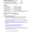
River Miles of the Green River through Seedskadee NWR
River Miles
Fontenelle Dam………………….…....…0 river mile
Slate Creek Campground ……….…...4.6 miles from Fontenelle Dam
N. Boundary of Refuge…………..……7.3 miles from Fontenelle Dam
Upper Dodge Bottoms Boat Ramp…..9.6 miles from Fontenelle Dam
Hay Farm Boat Ramp…………….....16.6 miles from Fontenelle Dam
Highway 28 Bridge Boat Ramp.........25.2 miles from Fontenelle Dam
6 mile Hill Boat Ramp........................34.3 miles from Fontenelle Dam
S. end of Big Island off refuge...........42.8 miles from Fontenelle Dam (estimate no boat ramp)
OCI Bridge / County Rd 6………...…..44.8 miles from Fontenelle Dam (primitive boat ramp)
River Miles between Boat Ramps
Slate Creek Campground to Dodge Bottom Boat Ramp...................5 miles
Dodge Bottom Boat Ramp to Hay Farm Boat Ramp........................7 miles
Hay Farm Boat Ramp to Highway 28 Boat Ramp............................9 miles
Highway 28 Boat Ramp to 6 Mile Hill Boat Ramp............................10 miles
6 Mile Hill Boat Ramp to OCI/County Rd 6 primitive pull out..…......10 miles
Estimated Float times**
Drift boat..............................................1.5 river miles an hour***
Canoe/Kayak........................................2 river miles an hour***
***Float times are estimates and will vary greatly with river flows, wind, and chosen watercraft. Larger watercraft, high wind and lower river flows will result in slower float times, while smaller watercraft and higher flows will result in faster float times.
**Float time speeds were estimated with no wind and at average river flows of 800 cfs (cubic feet per second) – check the U.S. Bureau of Reclamation website to determine current Green River flows above the Refuge at https://www.usbr.gov/rsvrWater/rsv40Day.html?siteid=916&reservoirtype=Reservoi or https://waterdata.usgs.gov/nwis/uv?site_no=09211200&legacy=1
River Hazards
- The weather can cause some of the most dangerous situations. Be sure to check the weather forecast for the refuge before you come. NOAA is a great resource - http://forecast.weather.gov/MapClick.php?lat=41.91351937007709&lon=-109.9127197265625&site=riw&unit=0&lg=en&FcstType=text
- Wind generally picks up in the afternoon on the refuge and summer thunderstorms in the afternoon can dramatically drop temperatures. When on the river, be prepared for cold or wet weather even in the height of summer.
- Beware of hazards on the river, the refuge maintains 'rock sills' which are instream structures that help create fish habitat on certain side channels or provide water to ditches that feed our managed wetlands. Most of the rock sills or structures have a slot in the middle, be sure to aim for the middle of the structures and go through straight. Feel free to contact us.
*For more information on floating the Green River upstream of Seedskadee and Fontenelle Reservoir:
Miles estimated using GIS/Arc in June 2025.