An official website of the United States government
Here’s how you know
Official websites use .gov A .gov website belongs to an official government organization in the United States.
Secure .gov websites use HTTPS A lock ( ) or https:// means you’ve safely connected to the .gov website. Share sensitive information only on official, secure websites.
Have you dreamed of exploring the Ohio River and its islands? This is your chance! Each of the 22 islands that make up the refuge have unique characteristics and history. Nothing brings this to life like actually visiting the islands! While a motorboat may seem desirable because it is quick and easy, here at the refuge, we appreciate a challenge; there’s merit in seeing the river and the islands at a slower pace, putting in the effort required of a kayak or canoe.
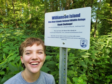
An Island sign like this one can be found on each island. Take a selfie with all twenty island signs to complete the kayak challenge and win a prize!
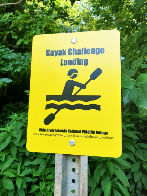
The challenge, then, is simple: visit all of the 20 refuge islands on this list by kayak or canoe. Each of these islands has a special island sign located at a high and accessible point on the island (there is also an accompanying yellow sign on the shore which indicates the suggested landing point; usually the island sign is just inland from the yellow landing sign). Take a selfie at all 20 island signs and share them with us at the visitor center to receive prizes galore! (Of course, the real prize will be the experiences gained while accomplishing this worthy goal).
The Refuge Islands required to complete the challenge (from upriver to downriver, with closest public access point) are:
Phillis Island, PA , 39 acres Ohioville Borough Boat Ramp, Calcutta Rd off SR 39/68, Midland, PA
Georgetown Island, PA , 16 acres Ohioville Borough Boat Ramp, Calcutta Rd off SR 39/68, Midland, PA
Captina Island, WV, 17 acres Powhatan Point Public Ramp, Powhatan, OH
Fish Creek Island, WV, 48 acres Fish Creek Public Access Site, 11 miles south of Moundsville, WV, off SR 2 at mouth of Fish Creek
The yellow landing sign for the kayak challenge. This sign will be on the island shore, visible from the river.
Paden Island, WV, 81 acres Paden City, WV, public access ramp at Paden City Park off SR 2
Williamson Island, WV, 126 acres Paden City, WV, public access ramp at Paden City Park off SR 2
Witten Towhead, WV, 8 acres Paden City, WV, public access ramp at Paden City Park off SR 2
Wells Island, WV, 43 acres Paden City, WV, public access ramp at Paden City Park off SR 2
Mill Creek Island, WV, 19 acres Paden City, WV, public access ramp at Paden City Park off SR 2
Grandview Island, WV, 8 acres Paden City, WV, public access ramp at Paden City Park off SR 2
Grape Island, WV, 45 acres St. Marys public access ramp at St. Marys off SR 2
Middle Island, WV, 235 acres Street access in St. Marys , WV , off SR 2 via George Street, St. Marys public access ramp at St. Marys off SR 2
Broadback Island, WV, 51 acres St. Marys public access ramp at St. Marys off SR 2
Buckley Island, WV, 160 acres Williamstown public access ramp under, under SR 14 bridge in Williamstown, WV
Muskingum Island, WV, 93 acres Williamstown public access ramp under, under SR 14 bridge in Williamstown, WV
Neal Island, WV, 104 acres Belpre, OH, public access ramp off Blennerhassett Ave.
Buffington Island, WV, 162 acres Ravenswood public access ramp off SR 68 in Ravenswood, WV
Letart Island, WV, 29 acres Letart public access site off SR 62 in Letart, WV
Manchester 1 Island, KY, 20 acres Manchester pubic access ramp (Island Creek), SR 52, Manchester, OH
Manchester 2 Island, KY, 94 acres Manchester pubic access ramp (Island Creek), SR 52, Manchester, OH
Doing all the islands at once would be a formidable adventure, since they are scattered over 360 miles of river. It may be more practical for most visitors to consider a series of short trips. (NOTE: Those wishing to pursue a longer, multi-night trip on the river may obtain a special permit to camp on the islands; contact refuge staff to learn more!). The islands are sometimes quite large, so finding the Island Sign by chance would be a challenge. To avoid confusion and save time, be sure to visit and explore our interactive Kayak Challenge Map. The map includes the locations of the landing site and island sign for each of the islands.