Motorized Boating
The waters in and around the refuge can be accessed at several locations managed by the refuge, Dorchester County Highway Dept., and Maryland DNR. Be aware that navigation can be difficult, especially in the Blackwater River, due to submerged mudflats, a meandering unmarked channel, and shallow water tidal changes. Much of the open water on the Blackwater River is not suitable for water-cooled motors. This area is best suited for canoes or kayaks. If you bring a motorized boat, we suggest using small outboards or mud motors, or electric trolling motors. A map of the refuge's water trails can be found below.
The refuge has a soft launch and parking area on the north side of the Route 335 Bridge at the Blackwater River. Boats can be launched by hand only. Boats can be trailered to the site (there are parking spaces available for trailers), but trailers are not allowed on the launch. Small power boats can be launched here if they are small enough to be carried to the launch. This launch is only open sunrise to sunset.
There is also a launch on Key Wallace Drive directly adjacent to the Little Blackwater River Bridge. Vehicles are only allowed to park temporarily while loading or unloading watercraft. This launch is closed during the seasonal refuge waters closure Oct. 1st - March 31st.
There are two public boat ramps managed by Dorchester County Highway Dept.; Smithville Bridge ramp located at Beaverdam Creek on Smithville Road (west side of refuge), and the Shorters Wharf ramp located at the Blackwater River on Maple Dam Road (southeast side of refuge). Boats can be trailer-launched at both of these sites.
Maryland DNR manages the Bespitch Ferry Boat Ramp at the Transquaking River on Bespitch Ferry Road (east of the refuge), which has facilities for trailer-launching boats. Maryland DNR also manages a soft launch for the upper Little Blackwater River off of Egypt Road (north of refuge). Be aware that this launch is small, located down a rough dirt road, and closed during the entire Maryland waterfowl season.
There is no special permit required to launch private boats in Dorchester County.
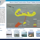
NOTICE TO BAY BOATERS: There is a safety zone around and adjacent to Barren Island during the construction of breakwaters. Please see the bulletin below for details. To find out more about the construction at Barren Island, please visit this website.
For a map and details of water access sites in Maryland, check out this Maryland DNR web site.
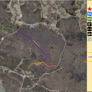
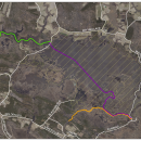
Wayfinding Maps
Wayfinding maps for Blackwater’s water trails are available using smartphone apps that support geospatial PDF files, such as FO MAPS (FaenaOffline). These apps use your phone’s GPS to find your location, and work without a signal from your carrier. They are available for Apple and Android devices. After installing the app on your phone, download the Blackwater Geospatial Paddling Map below to use with the app while paddling the refuge's water trails. Learn how to use the maps here.