Ongoing NRDAR Cases
SE Idaho Phosphate Mine NRDAR
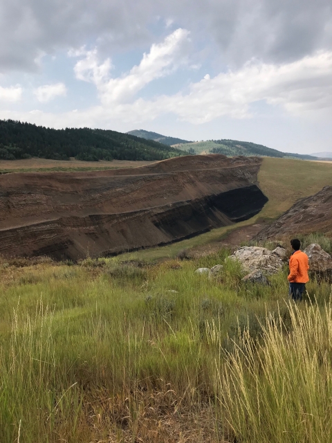
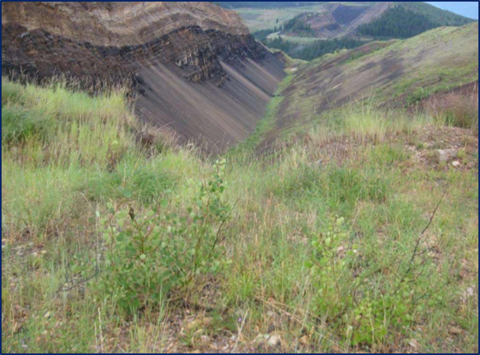
Summary: Phosphate exploration and mining in southeast Idaho was first conducted in the early-1900s, with mining activities continuing to the present day. Large-scale phosphate mines in the region consist of open pit or contour strip operations. Historic phosphate mining operations involved removal of soils and rock to access the phosphate ore. As ore was excavated, overburden rock and waste shales containing selenium were excavated. This overburden and waste shale were placed adjacent to mine pits, or backfilled into pits. Historic reclamation practices changed throughout the mining period from little to no reclamation requirements to today's more stringent standards.
The historic mines under investigation had varying degrees of reclamation requirements, including regrading of slopes and various revegetation seed mixes. Some of the vegetation planted during reclamation is now known to accumulate selenium at levels that harm or kill livestock. The resultant combination of non-selective waste material placement, in addition to minimal to non-existent reclamation, allowed for infiltration of water into the dumps/pits and oxidation of mine waste.
Selenium is a naturally occurring element in the environment, and an essential micronutrient for humans, plants, and wildlife. However, at too high of concentrations, selenium can be toxic. Mining processes resulting in oxidation of the selenium bearing mine waste results in a selenium oxidation state that makes it highly water soluble, mobile, and toxic. Past mining and reclamation practices have resulted in the interaction of water with selenium-bearing material, leading to selenium contamination of surface and groundwater. Toxic levels of selenium have been detected in water, sediment, vegetation, and animal and fish tissues collected from phosphate mines in southeast Idaho.
Historic and current phosphate mining operations have occurred in southeast Idaho, with most individual mines occurring near the city of Soda Springs, Idaho. Mining impacts have occurred over an approximate 17,000 acre area within portions of Bannock, Bear Lake, Bingham, and Caribou Counties, Idaho. The the NRDAR project site contains 16 major open pit phosphate mines and two processing facilities.
In 2015, the Southeast Idaho Phosphate Mine Site Natural Resource Trustee Council (Trustee Council) was formed to develop and coordinate damage assessment activities at the Mine Site and to plan for the restoration of natural resources through the NRDA process. The NRDA process is separate from the CERCLA Remedial Investigation/Feasibility Study process. Under NRDA, the Trustee Council will evaluate if natural resources were harmed over the time that the area has been contaminated and will develop a restoration program to compensate for those losses, if necessary/appropriate.
Trustee Council: Under the Comprehensive Environmental Response, Compensation and Liability Act (CERCLA) when there is a release of hazardous substances, natural resource trustees are authorized to conduct a natural resource damage assessment and restoration (NRDAR) to obtain compensation for harm to natural resources. At the Southeast Idaho Phosphate Mine Site, the trustees will pursue the NRDAR process to identify and quantify natural resources injured as a result of the release of hazardous substances at the Mine Site to determine the restoration activities necessary to return the injured natural resources to baseline conditions and compensate the public and the environment for interim losses.
The Trustee Council currently consists of representatives from the U.S. Department of Interior, U.S. Department of Agriculture, State of Idaho, and Shoshone-Bannock Tribes.
Current and Past Mine Owners/Operators:
Agrium/Nu-West Mining, Inc
CF Industries, Inc.
FMC Corporation
Huntsman Advanced Materials, Inc.
Huntsman International, LLC
J.R. Simplot Company
Monsanto/P4 Production
Solvay USA, Inc.
Wells Cargo, Inc.
Coeur d’Alene Basin Restoration Partnership NRDAR
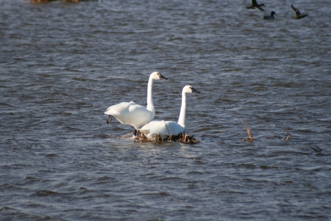
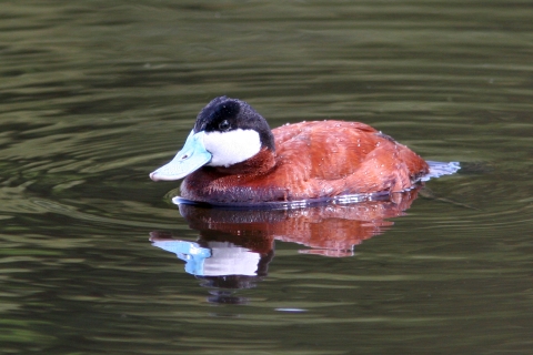
In 1883, precious metals were discovered in north Idaho, and silver mining would become a staple industry. In fact, the South Fork area of the Coeur d’Alene River would eventually produce more silver than any other area in the world and would eventually take on the name, Silver Valley. Unfortunately, turn-of-the-century mine and milling practices were still underdeveloped and resulted in a large amount of mine-waste contamination. This mine waste, in its “concentrated” form, had (and continues to have) wide spread, harmful impacts on the natural resources surrounding the waterways. Contaminated wetlands have become deadly to waterfowl, certain stretches of streams are devoid of life, there has been a decline in certain native fish species, and vegetation around some streams has died and resulted in significant erosion and poor water quality.
The Restoration Partnership was developed by the Coeur d’Alene Basin Natural Resource Trustees as a way to involve the public in natural resource restoration. Our primary mission is to return our natural resources to a healthy condition by developing and implementing a restoration plan for the Coeur d’Alene Basin. We engage the public by providing ways to help shape the plan, propose specific restoration projects, and partner with us on project work.
The Restoration Partnership includes both the Trustee Council and the Technical Staff. The Trustee Council provides oversight and guidance while the Technical Staff provides technical expertise. There is a hierarchical relationship that exists between the Trustee Council and the Technical Staff. The Trustee Council is comprised of representative from the Coeur d’Alene Tribe, DOI (U.S. Fish and Wildlife Service & Bureau of Land Management), Forest Service, and the State of Idaho (Idaho Department of Fish and Game and Idaho Department of Environmental Quality). The Technical Staff include representatives from each of the organizations.
The Coeur d’Alene Basin includes all the land that drains water into Coeur d’Alene Lake and out the Spokane River. It encompasses approximately 2.4 million acres of mountainous terrain with numerous streams, rivers, and lakes. It starts upstream to the east near the Montana border. Here, the South Fork Coeur d’Alene River flows through what is referred to as the ‘Silver Valley’. Mine waste contamination primarily affects the South Fork Coeur d’Alene River, Coeur d’Alene River mainstem, and Coeur d’Alene Lake. There are also areas in the Spokane River that have deposits of contamination. Therefore, the upper Spokane River is included in the description of the overall Coeur d’Alene Basin area.
The last of the major settlements was reached in 2011. The Trustees, working together under a Memorandum of Agreement, began the framework for the development of a restoration plan to kickstart the restoration process. The Trustees launched the Restoration Partnership shortly after in order to effectively engage the public in restoration efforts. Public Scoping for the development of the Restoration Plan began June 13, 2013 and ended on August 27, 2013.
Current projects consist of habitat restoration and conservation easements. More information on the following projects can be found here.
Schlepp Wetlands Restoration
Robinson Creek Wetlands Restoration
Pine Creek Project
Sherlock Creek Project
EF Moon Creek Project
Wetlands Conservation Project
Black Lake Ranch Wetlands Restoration
Cougar Bay Wetlands Enhancement Project
Smłich Cultural Fish Harvest Opportunities
Coeur d’Alene Lake Outreach - chdelm khwa chatq’ele’et (Defending Our Lake)
Culturally Significant Plant Restoration - uł qhesu’lumkhw (Land is Good Again)
Monitoring and Modeling Coeur d’Alene Lake’s Response to Restoration - chdelm khwa chatq’ele’et (Defending Our Lake)
Guł Hnch’mchinmsh Native Willow Nursery for Support of Restoration Actions throughout the Restoration Partnership Project Area
Hepton Lake Wetland Restoration Project - Guł Hnch'mchinmsh - Snyihms he mulshu’lmkhw (Swimmers Landing among the Cottonwoods)
St. Joe River Streambank Stabilization and Vegetation Project
Black Rock Slough Wetlands Project
Canyon Marsh Conservation Easement
Gene Day Pond
LiDAR Acquisition in Priority Restoration Areas
Wolf Lodge Creek Reach 3 Stream Restoration and Habitat Enhancement Project
Prichard Creek Conservation Easement and Restoration
Castle Rock Ranch – North Fork Coeur d’Alene River Riparian Restoration Project
Ongoing CERCLA Cases
SE Idaho Phosphate Mine
Summary: Phosphate exploration and mining in southeast Idaho was first conducted in the early-1900s, with mining activities continuing to the present day. Large-scale phosphate mines in the region consist of open pit or contour strip operations. Historic phosphate mining operations involved removal of soils and rock to access the phosphate ore. As ore was excavated, overburden rock and waste shales containing selenium were excavated. This overburden and waste shale were placed adjacent to mine pits, or backfilled into pits. Historic reclamation practices changed throughout the mining period from little to no reclamation requirements to today's more stringent standards.
The historic mines under investigation had varying degrees of reclamation requirements, including regrading of slopes and various revegetation seed mixes. Some of the vegetation planted during reclamation is now known to accumulate selenium at levels that harm or kill livestock. The resultant combination of non-selective waste material placement, in addition to minimal to non-existent reclamation, allowed for infiltration of water into the dumps/pits and oxidation of mine waste.
Selenium is a naturally occurring element in the environment, and an essential micronutrient for humans, plants, and wildlife. However, at too high of concentrations, selenium can be toxic. Mining processes resulting in oxidation of the selenium bearing mine waste results in a selenium oxidation state that makes it highly water soluble, mobile, and toxic. Past mining and reclamation practices have resulted in the interaction of water with selenium-bearing material, leading to selenium contamination of surface and groundwater. Toxic levels of selenium have been detected in water, sediment, vegetation, and animal and fish tissues collected from phosphate mines in southeast Idaho.
Historic and current phosphate mining operations have occurred in southeast Idaho, with most individual mines occurring near the city of Soda Springs, Idaho. Mining impacts have occurred over an approximate 17,000 acre area within portions of Bannock, Bear Lake, Bingham, and Caribou Counties, Idaho.
The USFWS remains actively engaged in remediating these lands by working through the CERCLA process with the US Environmental Protection Agency, the US Forest Service, the US Bureau of Land Management, the US Army Corps of Engineers, the Shoshone-Bannock Tribes, the Idaho Department of Environmental Quality, the Idaho Department of Lands, and the current and past mine owners. The Southeast Idaho Phosphate Mine Site Natural Resource Damage Assessment and Restoration (NRDAR) Trustee Council has issued the final Injury Assessment Plan (IAP) for the Southeast Idaho Phosphate Mine Site Assessment Area (Assessment Area). The IAP sets forth the Trustee Council's proposed approach for assessing potential natural resource damages related to the Assessment Area. A formal injury assessment plan is one of the first steps in a natural resource damages process being conducted pursuant to the Comprehensive, Environmental, Response, Compensation and Liability Act. The final IAP is available on this website in the Administrative Record section.