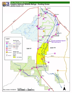
Arapaho National Wildlife Refuge supports diverse wildlife habitats, including sagebrush steppe uplands, grassland meadows, willow riparian areas, and wetlands. This 23,464-acre Refuge was established in 1967 primarily to provide suitable nesting and rearing habitat for migratory birds.
The U.S. Fish and Wildlife Service manages an unparalleled network of public lands and waters called the National Wildlife Refuge System. With more than 570 refuges spanning the country, this system protects iconic species and provides some of the best wildlife viewing opportunities on Earth.
You are exiting the U.S. Fish and Wildlife Service website
You are being directed to
We do not guarantee that the websites we link to comply with Section 508 (Accessibility Requirements) of the Rehabilitation Act. Links also do not constitute endorsement, recommendation, or favoring by the U.S. Fish and Wildlife Service.