Written By

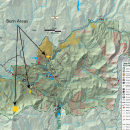
The U.S. Fish & Wildlife Service staff at the Little Pend Oreille National Wildlife Refuge is preparing for controlled burning. These burns are implemented to reduce hazardous fuel levels and for wildlife habitat enhancement and restoration. The map depicts the location(s) of proposed burning on the Refuge. We will begin controlled burning when the fuel and weather conditions allow us to meet burn objectives safely. Some controlled burning may be added, broken up into smaller units or delayed for another year.
Burning is planned to occur sometime between October through December depending on weather conditions. Burning will occur only when weather conditions are favorable on days when the smoke will disperse and mix with the predominant air flow. Controlled burns will be conducted in accordance with regional air quality guidelines.
Burn Units
Name | Acres | Township, Range, Section |
| Paulke Broadcast | ~362 | T45 R41 Sec 31 |
| Knutson Piles | ~260 | T34, R41, Sec 4, 5, 8, 9 |
| Rhymer Weir Piles | ~477 | T34, R40, Sec 14, 21, 22, 28, 29 |
For questions, please get in touch with the refuge management at either The Little Pend Oreille Office: 509-684-8384 or the Complex Manager at: 509-559-3020.
More Media from this Story
Media Contacts


Latest Stories