
Written By

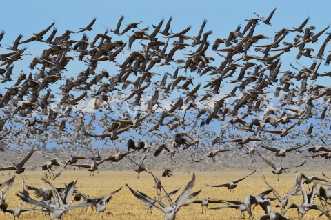
For those that appreciate natural wonders, the Platte River in Nebraska is renowned worldwide for one thing – sandhill cranes. Every year from February to April, more than half a million sandhill cranes visit the Platte River in one of the world’s most spectacular migration events.
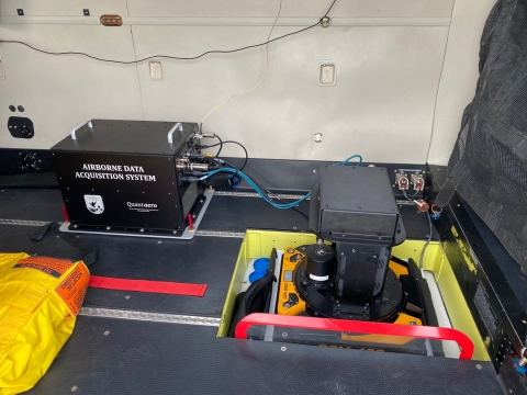
As part of our federal responsibility to conserve and manage sandhill cranes, our Migratory Bird Program has a robust monitoring program in place. In fact, our pilot biologists have been conducting aerial surveys of the Central Platte River Valley since 1979. Historically, our pilot biologists have flown low-altitude surveys to observe and count cranes and monitor the population size, but these low-altitude flights present safety risks to our pilot biologists. These survey flights are also conducted during the day, and therefore, could be missing cranes that are dispersed across different foraging areas. This is a challenge to effectively survey the population.
That’s why we are now exploring novel ways to incorporate automated methods for counting sandhill cranes at night using a highly efficient remote-sensing approach.
Since sandhill cranes congregate at night at their roosting sites near the Platte River, aircraft can use remote sensing to collect data on thermal infrared energy (i.e., heat mapping) to locate individual roosting cranes. This technology has the potential to reduce observer bias, allow data collection when cranes are highly aggregated at night, and because data can be collected at a higher altitude, lowers safety risks to our flight crew. However, manually counting wildlife on thermal images takes a lot of staff time and resources, and is highly variable in its results, so a more automated approach is needed.
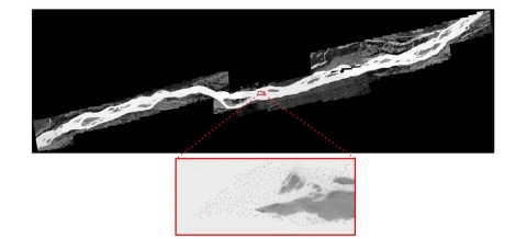
In a collaborative effort with our partners at the College of William and Mary and the U.S. Geological Survey, we have now demonstrated the efficiency of using the most cutting-edge technology available to automate the process of counting and locating sandhill cranes on the thermal images. We are using machine learning technology, which is a form of artificial intelligence. The machine learning results showed that accurate counts of sandhill cranes, including knowledge of their locations, can be achieved in minutes rather than months. This is the first application of machine learning for migratory bird surveys, but its success will inspire future efforts to use the combined technologies of remote sensing and machine learning.
Recreational Activities
Written By


