Written By

For the last couple of years, things haven’t been adding up for rufa red knots in Delaware Bay.
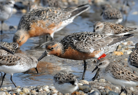
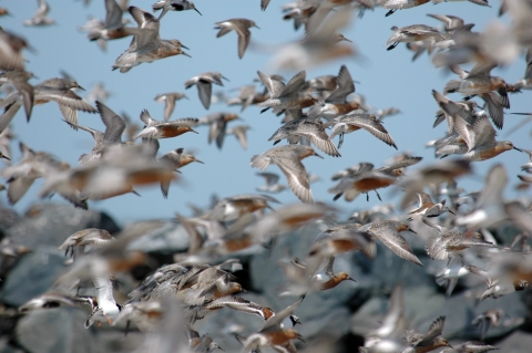
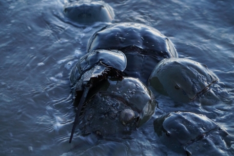
Each spring, thousands of these robin-sized shorebirds stop on bay beaches to rest and refuel, gorging on horseshoe crab eggs to gain weight for the final leg of their migration to nesting grounds in Canada’s Arctic tundra.
Around the same time, biologists flock to the bay to count them.
But recently, the two methods biologists use to survey rufa red knots have been telling different stories about the number that visit the bay, known as the stopover population.
Now partners from state wildlife agencies and the U.S. Fish and Wildlife Service are trying to figure out why.
Two different pictures
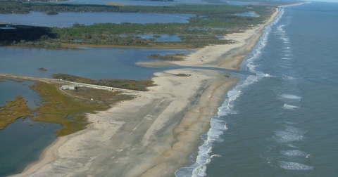
An estuary half the size of Rhode Island bordered by Delaware and New Jersey, Delaware Bay is so rich in food that 50 to 80% of rufa red knots stop there to feed in May and early June. That makes it a key site for monitoring populations of this federally threatened shorebird.
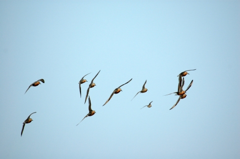
Since the 1980s, biologists have been conducting annual surveys by airplane at the anticipated peak of spring migration to get a snapshot of rufa red knot abundance and distribution in the bay.
The aerial count is a valuable indicator, but it can’t estimate the total number of knots using the bay each spring because individual birds come and go over the course of about a month. So, a second method was added in 2011.
Starting in early May, biologists conduct ground counts using spotting scopes to document birds marked with leg flags every three days at 20 priority beaches. This “resighting” data feeds into a statistical model that’s used to estimate the total stopover population of rufa red knots each year.
The numbers from these two surveys aren’t directly comparable: the aerial count is like a polaroid — a moment in time — while the total stopover population is more like a time lapse — capturing birds as they enter, linger in and leave the bay.
But the methods are complementary, providing different views of the same overarching trends.
Yet in 2021, the numbers were dramatically out of sync. That year, the aerial count was the lowest since the survey began in 1981, abruptly dropping 75 percent from the previous three-year average.
The total stopover population showed a different picture, essentially unchanged from the long-term average going back to 2011.
In 2022, it happened again. The aerial count was the second lowest on record, while the total stopover population edged down only slightly.
That disparity has left biologists with a mystery to solve: Why are these two survey methods telling different stories?
Bird’s-eye view
It’s important to understand that counting birds from a plane is no picnic.
“You’re flying as low as you can to get a good view of the flocks below,” explained Kathleen Clark, acting chief of the Endangered and Nongame Species Program for New Jersey Fish and Wildlife. For two decades, she was the one peering out the back window of a small plane counting moving objects below.
“It’s difficult because the plane needs to closely follow the Delaware Bay shoreline — which curves in and out with coves and points — while flying close to stall speed.” Meaning the minimum steady flight speed required to keep an airplane in the air and under control.
In addition to an iron stomach, good data collection under these circumstances requires experience. From 1986 to 2008, Clark was the counter, but since then the aerial team has seen high turnover. In response to the unusually low counts, New Jersey and Delaware plan to once again dedicate state agency staff to the effort with the goal of improving continuity.
The states are also adding a flight earlier in May. Clark explained that during her tenure conducting the survey, she would refresh her counting skills during flights early in the season, when there were fewer birds in the bay.
“When the flocks were small, I would make an effort to count every bird so I could get a mental picture of what 50 or 100 birds looks like,” she said. “Then I could apply that mental picture to bigger flocks.”
In addition to giving counters time to calibrate, the extra flight will provide an opportunity to catch peak migration if it comes early. Knots tend to leave the bay and head for the breeding grounds in droves on any given day near the end of May. Missing a big departure of birds means night and day for the count.
Transparency is also key to maintaining consistency, and the states plan to improve reporting by providing complete aerial and ground data — including observers, times and weather — for each survey date.
Ground truth
Because of the volume and variety of birds passing through Delaware Bay, the aerial count “is not an easy survey to do,” said Environment Canada senior research scientist R.I. Guy Morrison.
He would know. Morrison and his colleague Ken Ross from the Canadian Wildlife Service have conducted aerial surveys of stopover habitats in South America for 40 years.
He pointed out that the surveys in Delaware Bay have a significant, distinguishing feature: the concurrent ground count. “So, in a sense, a ground truth operation has taken place with each [flight].”
New Jersey and Delaware continue to work together to keep that ground operation going, which is no small feat, either.
“Coordination for the project never really ends, because as soon as the field portion of the project is over, we need to work with the data, evaluate the equipment, report to funders and partners, and ensure we are ready for the next field season,” explained Samantha Robinson, a program manager for Delaware Division of Fish and Wildlife who runs the Delaware Shorebird Project.
She and her colleagues hire seasonal staff in December, reach out to volunteers in February, and spend about two months determining when surveys will take place and who will conduct them. All new volunteers are paired with experienced staff to ensure consistency in data collection.
During the ground surveys, the teams also collect data on disturbances — dogs, planes, people, peregrine falcons — that may prevent birds from sufficiently resting and refueling during their grueling migratory journeys.
So what is going on in the bay?
Wildlife agencies are weighing several possible explanations for the unusual survey results in 2021 and 2022. First, the good news: There is no evidence that overall numbers of rufa red knots have declined recently. The population that winters at the southern tip of South America and migrates to the Arctic each year — among the farthest of any animal — has been low but stable since 2011.
If knot numbers are flat, then why have results from the two surveys diverged? They could deviate by chance, simply because they measure different things. The aerial survey data is inherently “noisier” — more inconsistent from year to year — than the total stopover population estimate. It takes several years for real trends in the aerial counts to become clear. Changes in observer can also increase “noise” in the data set, which is why the states are taking steps to put a more consistent team in place.
Another explanation for the low aerial counts could be timing — unusually large numbers of birds may have departed Delaware Bay before the aerial surveys happened. Biologists are combing through the data to see if the timing of when knots use the bay is changing, which could cause wider gaps between the aerial counts and the total stopover estimates. Some support for this theory is emerging from the data.
It’s also possible that fewer birds are stopping in the bay. Morrison said the most likely current scenario is that the number of birds using Delaware Bay “has indeed decreased, probably because many knots may have moved elsewhere.”
Coastwide perspective
Last year, the Service and state agency partners organized an aerial survey from south of Delaware Bay to northeast Florida. The goal was to better understand when peak numbers of red knots occur south of Delaware Bay to provide points of comparison.
Partners conducted three rounds of aerial surveys as planned for South Carolina and Georgia, where most rufa red knots in the Southeast were thought to concentrate. Unfortunately, a major storm rolled into the mid-Atlantic states, forcing the cancellation of the first aerial survey scheduled for North Carolina. The counts from both surveys for Delaware to Virginia, as well as a later survey over North Carolina after the storm blew over, produced lower than expected numbers based on aerial surveys from previous years.
“The storm definitely had an impact on shorebird numbers,” said Chuck Hunter, Southeast regional refuge biologist for the Service. But aerial surveys from South Carolina and Georgia aligned with anecdotal information on when peaks generally occur.
Portions of these surveys are set to be repeated in 2023. Over time, this kind of coastwide survey and monitoring will help determine if birds are shifting among stopover sites along the Atlantic coast of the U.S.
Other findings suggest there could be slight changes in stopover locations from year to year. But as of now, there’s no strong evidence of recent major shifts among stopover sites between Delaware Bay and sites to the south.
For instance, Virginia Tech conducts an annual ground count to estimate how many rufa red knots are using stopover habitat along the coast of Virginia. In 2022, the number nearly tripled, from a long-term average of about 7,000 to an estimated 20,000.
But those unusually high numbers were likely because the same storm that grounded the aerial survey in North Carolina also forced large numbers of birds to remain in the south.
Unknown unknowns
It’s still unclear whether rufa red knots are coming to Delaware Bay in lower numbers, staying for shorter periods, leaving earlier, or some combination of the above. But biologists are looking at factors that could discourage birds from using the bay, and some — food supplies, disturbance, and habitat — can probably be ruled out as causes of the odd 2021-2022 survey results.
Because they rely almost exclusively on horseshoe crab eggs for food in Delaware Bay, knots are known to avoid the bay in years with depressed or late horseshoe crab spawning, as happened in 2003, 2008 and 2020 due to low water temperatures.
However, beach surveyors reported good crab spawns in 2021 and 2022, the years the aerial counts were notably low. And in 2022, the Virginia Tech trawl survey, which scientists consider the gold standard for assessing horseshoe crab stock, confirmed that the overall crab population is increasing in the Delaware Bay region.
Similarly, wildlife agencies have not reported any recent increases in human disturbance or declines in habitat conditions in the bay — and continue to actively manage these threats.
Other factors, including peregrine falcons and weather, haven't been ruled out, but there is no definitive evidence that they’re linked to the low counts.
The peregrine falcon — itself an endangered species success story — hunts along the bay and coastal areas in other states. Although peregrines don’t catch many shorebirds, a falcon’s mere presence is known to drive knots from their resting and feeding areas. Both states continue to collect peregrine data and manage falcon nest structures in accordance with current science.
Weather or other unknown environmental factors could be at play. Counts for other species of shorebirds in the bay were also down in 2021 compared to previous years, supporting the theory that weather played a role. And the North Carolina storm likely influenced the birds’ selection of stopover areas in 2022.
Big picture
“Whatever is happening now, Delaware Bay will certainly maintain its central importance for red knots on northward migration,” said Morrison from Environment Canada. “With suitable conservation measures, the treasure that is Delaware Bay can be preserved, and last beyond the current redistribution [of birds].”
Many of those conservation measures — from habitat restoration to efforts to reduce disturbances — are already underway.
While we haven't yet solved the mystery of the diverging survey results in Delaware Bay, we are keeping sight of the bigger picture. “Regardless, we know rufa red knot populations are vulnerable,” the Service’s Hunter said.
The Service and many partners are working to make sure these birds find the resources they need during their annual pitstop in Delaware Bay.