Written By

Manns Harbor, North Carolina – Here, on the front lines of the battle against climate change climate change
Climate change includes both global warming driven by human-induced emissions of greenhouse gases and the resulting large-scale shifts in weather patterns. Though there have been previous periods of climatic change, since the mid-20th century humans have had an unprecedented impact on Earth's climate system and caused change on a global scale.
Learn more about climate change , the war looks lost.
Point Peter Road leads straight into the Croatan Sound where rising seas, higher tides, and monstrous storms batter the fragile coastline. The saltwater poisons and erodes the peaty soil before what’s left disappears under the relentless waves. A man-made canal carries the seawater inland where it kills cypresses and pines and turns the forest into shrubby marsh. Freshwater, blocked from running into the bay by the rising sound, pools under trees and kills them.
This corner of Alligator River National Wildlife Refuge stands no higher than one foot.
“This particular stretch of the coastline, due to the hydrology, experiences extremely high rates of erosion,” says Sarah Toner, visitor services manager for the Coastal North Carolina National Wildlife Refuges Complex. “This is ground zero.”
All, however, may not be lost. A healthy infusion of climate-fighting cash — $27.5 million — from the Inflation Reduction Act will likely help Alligator River and a handful of other nearby refuges and state lands keep the ravages of climate change at bay. The U.S. Fish and Wildlife Service and partners will deploy “nature-based solutions,” including oyster reefs, marsh sills, dredge spoils, and re-wetted peatlands, to protect the coast from a steadily warming world.
“The threat is that more of these communities out here will become really challenging places to live with more flooding, more soil erosion, and more frequent wildfires,” says Chris Baillie, the climate adaptation coordinator for the North Carolina Coastal Federation. “There is a need to be really judicious in how climate funding is spent because there simply isn't enough money out there to address all the climate vulnerabilities faced by people and nature.”
'We’re trying to hang on’
Alligator River Refuge — “mile after uninhabited mile on both Highways 64 and 264,” reads a 1990 Service brochure — is an otherworldly expanse of dredged peat fields, fresh and brackish marshes, pocket forests, and lakes. Established in 1984, the refuge is surrounded by water and serves as the second line of defense, behind the Outer Banks, against a marauding Mother Nature. The 152,000-acre refuge is one of nine, low-lying refuges in eastern North Carolina all facing varying degrees of climate-induced threats.
Its purpose: protect the pocosin wetlands which provide ample habitat for the wintering waterfowl that fill the skies, the black bears in numbers found nowhere else on the East Coast, and the elusive, and federally endangered, Red Wolves. Another goal: to save the eastern black rail, “the most secretive of the secretive marsh birds and one of the least understood bird species in North America,” according to the Atlantic Coast Joint Venture, a federal-state bird conservation partnership.
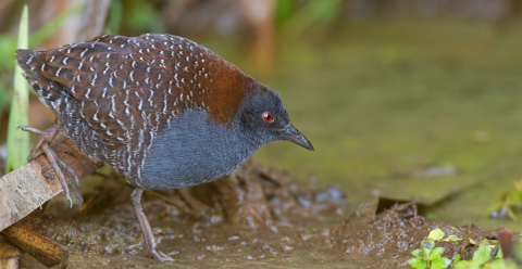
The birds, federally listed as threatened, once flitted across salt marshes from Connecticut to Florida, including those alongside Point Peter Road. But habitat destruction, due to drained marshes and rising seas, has decimated the population by 90 percent. Maybe 350 breeding pairs remain, according to the Joint Venture, “a catastrophic decline over the past 30 years.”
Seas, worldwide, rose on average 1.2 millimeters a year for most of the 20th century. Since1993, though, the rate has more than doubled to 3.2 millimeters, according to the United Nations Intergovernmental Panel on Climate Change. Yet reports show the seas have been rising three to four times as much as the global rate between North Carolina and Massachusetts which leads to more frequent inundations and salt marsh salt marsh
Salt marshes are found in tidal areas near the coast, where freshwater mixes with saltwater.
Learn more about salt marsh loss.
“We’re losing a lot of land,” says Fred Wurster, a Service geomorphologist who’s leading the climate-fighting project. “Not only is the shoreline retreating rapidly, but the habitat we manage is transitioning very rapidly to salt marsh or open water. It creates a situation where we’re trying to hang on to what’s here long enough to give species a chance to move further inland.”
Much of Alligator River Refuge, like much of the coastal plain, was logged of cypress and Atlantic white cedar and drained for farmland which dried out the peaty soils. When the mega-farms proved unprofitable, the scarred and desiccated fields became refuges and wildlife management areas. Yet the salty water from surrounding estuaries creeps relentlessly inland poisoning the soil and further drying the spongy peat bogs. Without rain, the carbon-rich pocosins become tinderboxes for wildfires than can last months and cause significant damage to the ecosystem, and global health.
In 1955, a fire on the other side of the Alligator River, burned 203,000 acres. Thirty years later, the Allen Road fire burned 95,000 acres. The 2008 Evans Road fire, though, sticks most in locals’ craws. It burned — above and below ground in the deep peat — for seven months before it was extinguished. Air quality as far north as Norfolk, Virginia suffered. More than 40,000 acres, mostly in the Pocosin Lakes National Wildlife Refuge, burned. The Service estimated that the fire released six million tons of climate-warming carbon dioxide into the atmosphere.
Peatlands cover only three percent of the world’s land mass, yet they store twice as much carbon as all the planet’s forests. They are enormous carbon “sinks.” Duke University calculated in 2022 that rewetting and restoring 250,000 acres of abandoned peat bogs across the Southeast could prevent 4.3 million tons of carbon dioxide from escaping into the atmosphere each year.
“Southern pocosin peatlands punch far above their weight in terms of their capacity for carbon storage,” says Curtis Richardson, founding director of the Duke University Wetland Center. “Acre for acre, they can store significantly more carbon than forests or grasslands.”
Largest climate-fighting act
Arch Bracher stood at the end of a long pier casting mullet into Rose Bay where the freshwater Pamlico River turns brackish at the Pamlico Sound. It was an unseasonably warm, Carolina-blue morning and the red drum weren’t biting. And neither was Bracher when talk turned to climate change.
“They talk about sea level rise, blah, blah, blah,” says Bracher, a charter boat captain who runs the Pelican out of Oregon Inlet. “But the ocean’s not getting higher. It's just eating away stuff. They're talking about the water rising one inch over the next 100 years. I think that’s just propaganda.”

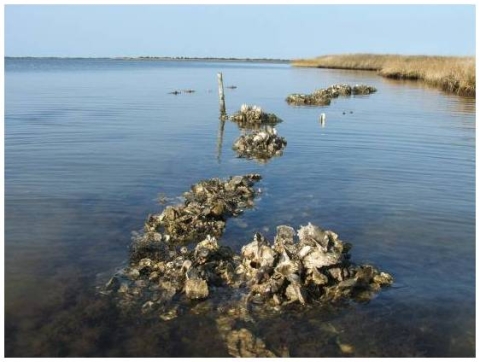
A forest of dead, ghostly pines stood in the adjoining Swanquarter National Wildlife Refuge. Rising seas have eaten away the banks on both sides of the Bell Island Pier. A study a decade ago showed that an average of three feet of peaty soil disappeared each year due to ever-higher water. In 2012, The Nature Conservancy and the Service built a limestone sill 30 feet offshore. The reef reduces the power of the waves that pound the shoreline. Erosion slows. Sand and silt accumulate between the shore and the sill creating new beach for plants to take hold and marsh to reform. Oysters and mussels attach to the marl further strengthening, and renourishing, the reef.
“We’re building good oyster habitat, and getting recruitment, which helps with water quality as well,” says Aaron McCall, a regional land steward for The Nature Conservancy. “We don’t want to reach a tipping point where the system gets destroyed and it doesn’t provide any service to the environment or the local community.”
The Conservancy surveyed 10 sites — six protected by the reef, four unprotected — near the pier to determine whether erosion continues apace. Erosion stopped or slowed at all protected sites; it continued at the unprotected sites.
Limestone sills and oyster reefs are major components of so-called living shorelines and hallmarks of nature-based solutions to climate change. And they are precisely the types of projects funded by the Inflation Reduction Act that will be built across eastern North Carolina.
The IRA, at $369 billion, is the largest climate-fighting package in U.S. history. Its goal is to move the country fully towards renewable energy while reducing greenhouse gas emissions that fuel climate change. Billions of dollars are dedicated to agricultural conservation, forest protection, and wildfire risk reduction.
“There is often an assumption that tackling the climate crisis requires only technological solutions,” the White House said in November 2022 describing the IRA’s nature-based offerings. “Too often, the power of nature is overlooked and undervalued as a core element of a more just, livable world today and for future generations.”
The Service received $250 million; nearly half will help restore federal wildlife refuges and state wildlife management areas “that have been affected by adverse weather events.” No other project received as much money — $27.5 million — as the Albemarle-Pamlico region. The North Carolina Wildlife Resources Commission will likely get $5 million of that amount for climate-fighting work at wildlife management areas across the coastal plain.
There’s really nothing new or radical about enlisting nature to solve nature’s problems. The Roosevelt administration, during the Dust Bowl, paid farmers to plant 220 million trees from Texas to North Dakota to reduce erosion, protect livestock, and create wildlife habitat. Oyster reefs have long been deployed off Florida. Sand is pumped on barrier islands across the Mississippi River Delta. The Service and partners also spent $38 million pumping sand, restoring marsh, and replumbing the hydrology at Delaware’s Prime Hook National Wildlife Refuge which was decimated by Superstorm Sandy in 2012.
Nature-based engineering contrasts the coastal hardening tactics — sea walls, jetties, bulkheads, rip-rap — of centuries past. Sea walls, for example, only protect shorelines for so long against rising seas. More vicious storms and hurricanes easily top them. And the walls may protect one section of coast while causing erosion along another section.
“Nature-based solutions are definitely the way to go because you’re designing something that takes into account the natural hydrology and actual landscape in the first place,” Wurster says. “The things you’re building will be more stable in the long run. You’re not fighting against nature. Plus, these strategies tend to be more resilient and less expensive in the long run.”
Buying time
Climate change’s past, present, and alarming future unspools along Mashoes Road on Alligator River Refuge’s north end. A somewhat healthy marsh on the right gives way to shrub, pine, and oak on the left. In the distance, the skeletal remains of once-prominent trees hug East Lake. Eventually, inexorably, the salt water will reach the forest and destroy it too.
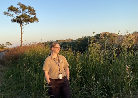
“We see, year after year, the forest retreating and turn into this ghost forest,” says the refuge’s Toner, a biologist by training. “We’re trying to keep what we have here for as long as we can.”
Help’s on the way. Much of the $27.5 million will be spent restoring fragile coastal ecosystems via shoreline protection and peatland restoration. IRA money could plug drainage ditches and add dikes, tidal gates, or wooden risers to keep saltwater at bay while restoring the natural flow of water over the land. Culverts may be dug to let water flow beneath roads. Restoration, or preservation, of trees, shrubs, and wetlands could provide habitat for Red Wolves, black rails, and other migratory birds. Communities near and far will likely benefit from a reduction in wildfires and a sequestration of carbon.
Oyster reefs, for example, could be built, or expanded, at Cedar Island and Pea Island refuges. A canal might be dredged, and a pump station added, at Lake Mattamuskeet. A logging road could be removed at Roanoke River refuge to let water flow naturally again. The marsh sill at the Bell Island Pier could be expanded.
Work is set to begin in 2024. Baillie, with the nonprofit Coastal Federation, says there’s no time to waste.
“It would be really disingenuous to say, ‘Hey, these funds are going to take care of all of our problems and let people live the way they currently do forever,’” he says. “There are tough decisions to be made. But these funds can have a big impact helping people and natural communities adapt while buying some time to figure out what’s the best way forward.”
This story is part of a collaborative effort to explore how climate change is impacting hunting and fishing across the United States.