Land Protection Planning
The U.S. Fish and Wildlife Service is proposing to expand conservation in the Southern High Plains region including Muleshoe National Wildlife Refuge (Bailey County, Texas) and Grulla National Wildlife Refuge (Roosevelt County, New Mexico) by preparing a Land Protection Plan. The Service has worked with conservation partners to identify a conservation strategy centered on maintaining the long-term viability of the two existing refuges and the Southern High Plains region. The strategy focuses on key grassland and wetland habitat associated species including sandhill crane, lesser prairie-chicken, and pronghorn antelope.
A Land Protection Plan better positions the conservation community to address the current and future needs of wildlife and wildlife habitat in the Southern High Plains region as opportunities for future conservation arise. Draft expansion boundaries have been identified, including priority areas within. The proposed boundary encompasses the entire area under consideration for conservation partnerships. Priority areas include lands where conservation efforts will have the highest anticipated benefit to wildlife and habitat.
What to Expect
- The Service’s Land Protection Planning process adheres to the
following principles:
If a Land Protection Plan is approved, conservation easements, fee title acquisition, or other conservation programs will only move forward with willing landowners, sellers, and partners - Decision making based on rigorous science and measurable conservation outcomes
- Robust coordination with state, local, tribal, and private stakeholders
Why Are We Proposing to Expand?
The Service is responding to the best available science and local conservation partners, landowners, and stakeholders who have expressed that Muleshoe and Grulla National Wildlife Refuges should expand. The proposed expansion addresses changing landscape drivers including energy development, habitat fragmentation, reduction in Conservation Reserve Program acres, aquifer decline, and shrinking wetland habitat.
Once a Land Protection Plan is finalized the Service may begin to:
- Work with conservation partners and willing sellers to obtain conservation easements or fee title interest in lands within the expansion boundary
- Plan restoration and conservation projects on lands within the expansion boundary
Participation in Land Protection Plan programs will be voluntary. Conservation easements, fee title sales, or other conservation programs will only move forward with willing landowners, sellers, and partners.

What Does the Expansion Process Look Like?
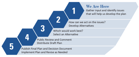
The expansion process begins with a science-based review of the species and habitat types that occur in the Southern High Plains region. Public input is an important next step in the planning process that helps the Service understand the issues and opportunities for a potential refuge expansion in the future. After a gathering input from conversations with stakeholders, the Service will develop a draft Land Protection Plan that details the proposed expansion boundary and defines priority areas where conservation efforts will have the most benefit for wildlife. The draft plan, including proposed boundaries and priority areas, will be released for public comment and subject to environmental review before a Land Protection Plan is finalized. See the map to the right for the draft boundaries and Service priority areas under consideration.
Muleshoe and Grulla National Wildlife Refuges conserve and enhance habitat that is important to migratory birds and many resident species of wildlife.
What Are the Benefits?
The long-term benefits of the proposed Land Protection Plan include greater habitat connectivity and protection for:
- Sandhill Crane
- Scaled Quail (Blue Quail)
- Lesser Prairie-Chicken
- Pronghorn Antelope
- Mule Deer
- Other migratory birds and wildlife
The Service also expects the following benefits to the Southern High Plains Region:
- Increased local revenues from new opportunities for outdoor recreation (hunting, birdwatching, hiking, photography, etc.) on public land
- Grazing opportunities as part of best management practices for grassland habitat
- Long term stability for conservation lands and compatible recreation opportunities
- Increased grant funding opportunities for local conservation groups
Frequently Asked Questions
If I own land in the expansion boundary or priority area, would I ever be forced to sell?
No. The expansion boundary and priority boundaries are not refuge boundaries. All property acquisition by the Service would be on a voluntary basis (willing buyer/willing seller only) and only lands in which the Service acquires a fee/title realty interest would become part of a refuge. Lands identified in the expansion boundary and priority area are in private and public ownership. It is not the intent of the Service to acquire lands already in public ownership. Only in the presence of willing sellers and only after detailed planning could lands be acquired for the Refuge.
If I own land in an area that the Service says has high natural resource values, will my property ever be condemned?
The Service will not use eminent domain or condemnation to acquire lands. As the opportunity arises, the Service will acquire land from interested landowners within the planning areas who wish to sell or place easements on their land for the conservation of wildlife.
Will my rights as a property owner be infringed as a result of the refuge expanding its boundaries?
No. If lands are developed into a National Wildlife Refuge, the Service will have no more authority over private land within or adjacent to the boundaries of the refuge than any other landowner. Landowners retain all the rights, privileges, and responsibilities of private land ownership.
Is this the recovery plan for lesser prairie-chicken?
No. This is not a recovery plan or strategy for the lesser prairie-chicken as recovery planning is its own process. Conservation of the lesser prairie-chicken, regardless of its listing status, is reliant upon efforts well beyond this Land Protection Plan.
If the lesser prairie-chicken is listed as either threatened or endangered under the Endangered Species Act (ESA) the Service will then begin to outline steps that would need to occur for recovering the species. The recovery plan identifies recovery criteria for review of when a species may be ready for downlisting or delisting, and methods for monitoring recovery progress.
If a Land Protection Plan for expanding Muleshoe and Grulla National Wildlife Refuges is finalized, any resulting conservation benefits for the lesser prairie-chicken realized from this effort may contribute towards meeting any potential recovery goals established through a recovery planning process, should the lesser prairie-chicken be listed.
Will this effort effect the listing determination for the lesser prairie-chicken?
No. This is a planning effort that may result in conservation benefits to the lesser prairie-chicken in the future if finalized. The scope of any potential benefits to the lesser prairie-chicken are unknown at this time and will depend upon the amount and location of any potential future conservation that may arise from this planning process.
I am a landowner; how will a conservation easement conservation easement
A conservation easement is a voluntary legal agreement between a landowner and a government agency or qualified conservation organization that restricts the type and amount of development that may take place on a property in the future. Conservation easements aim to protect habitat for birds, fish and other wildlife by limiting residential, industrial or commercial development. Contracts may prohibit alteration of the natural topography, conversion of native grassland to cropland, drainage of wetland and establishment of game farms. Easement land remains in private ownership.
Learn more about conservation easement or fee-title sale benefit me?
Conservation easements provide permanent protection to natural resources while retaining private landownership. The landowner retains ownership of the land but sells certain rights identified and agreed upon by both parties. The value a landowner may expect to receive for an easement is dependent on the number of rights the landowner chooses to sell. Because ownership of the land remains with the individual, the property remains on the state and local tax rolls. The Service pays fair market value for property and any rights purchased.
Fee-Title Acquisition involves an interested landowner requesting the U.S. Fish and Wildlife Service acquire most or all the rights to their property. There is a total transfer of property with the formal conveyance of a title to the federal government. In some instances, certain rights such as water rights, mineral rights or use reservations, such as grazing, can be negotiated at the time the property is transferred in ownership. The Service pays fair market value for property and any rights purchased.
To learn more:
Contact Refuge Manager Jude Smith, at 806-674-6369.
Email with questions or comments to R2_plancomments@fws.gov