

2026–2027 Hunting Regulations Now Available
The updated Lower Suwannee National Wildlife Refuge Hunting Regulations for the 2026–2027 season are now published and ready for hunters.
A downloadable PDF of the regulations is available online.
If you would like a paper copy of the brochure, please mail a self‑addressed, stamped envelope for each requested brochure to:
Lower Suwannee National Wildlife Refuge
16450 NW 31st Place
Chiefland, Florida 32626
Phone: 352‑493‑0238
For additional questions, you may also call 352-493-0238
Visit Us
Regulation of recreation activities allows for public enjoyment of the Refuge while still protecting the wildlife and habitats.
The Refuge is open from sunrise to sunset for appropriate recreational uses including boating, hiking, fishing, biking, photography, and birding. Formal interpretation and education visits can be arranged, though we do not lead such events.
There are three distinct areas to the LSNWR:
Shellmound 9 miles north of Cedar Key;
Levy County side of the LSNWR with a 9 mile Nature Drive and three formal trails as well as many grass roads that are open to walking and biking;
Dixie County side of the LSNWR.
Visitors access the Refuge via the Nature Drive in Levy County and the Dixie Mainline and County Road 357 in Dixie County. Roads throughout the refuge are lime rock; visitors must maintain the posted speed limit. No camping or overnight parking is allowed within the Refuge; although, there are County campgrounds adjacent to the refuge on both sides of the Suwannee River.
Lower Suwannee
Winter visitors will enjoy the mild weather, but sunscreen is suggested. Summer requires lots of water, bug repellent and sunscreen – maybe even a hat and sunglasses. Cell phone reception is spotty in the backcountry; most of the area is backcountry and Verizon seems to work best.
Activities
There are 194 miles of refuge roads and trails for public access to view wildlife, hike, bike, drive in your vehicles, photograph, and fish. The maintained lime rock roads are open to public driving. The grass roads behind the locked gates are open to hiking and biking.
The refuge hosts 10 different hunts; please consult the "Refuge Hunt Brochure" and "How to Buy a LSNWR Quota Hunt Permit" in our Library.
For mobility impaired hunters who wish to access the Refuge by alternative access means please read "Overview for Mobility Impaired Hunters SUP" and "Alternative Mobility Hunt Permit" in the Library
Trails
Refuge trails, boardwalks, fishing piers, overlooks, and kiosks provide family-friendly wildlife viewing areas. The refuge has few hills, so all trails have very little elevation-gain, offering easy walks without losing any of the nature-experience opportunities. Need help navigating? Print your own trail map or pick up one of the yellow trail description brochures when you arrive on the refuge.
The Friends of the Refuges Website has many refuge maps for public use.
Related Documents
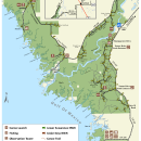
Lower Suwannee Map
Locations
From US 19 in Chiefland, Florida, turn south onto County Road 345 and then go to County Road 347; drive for approximately 11 miles to the hamlet of Fowlers Bluff. As you pass Fowlers Bluff follow the big brown information signs. You can also do a computer search using these words: "Vista, Levy County, Florida", or our address "16450 NW 31st Place, Chiefland, Florida 32626".
The headquarters office has a visitor contact station open 7:30 - 4:00 Monday - Thursday. Call before you come on Fridays. The contact station provides maps, brochures, information, and a warm welcome for visitors. Restroom facilities, a pollinator garden, hiking, and paddling information are also available. If you are coming on a Friday or a weekend, definitely call or text as no one might be there; John Stark’s cell (+1) 850-527-8535 or the office (+1) 352-493-0238 x224.
The Friends of the Refuges Website (https://www.friendsofrefuges.org/maps.html) has many refuge maps for public use.
Dixie County
Dixie Mainline North Entrance: 29° 26.504'N, 83° 11.234'W
Dixie Mainline South Entrance: 29° 20.819'N, 83° 7.516'W
Shired Island Boat Launch and Beach Trail: 29° 23.893'N, 83° 12.108'W
Numerous refuge roads off of Dixie County Road 349 between: 29° 28.419'N, 83° 0.666'W, south to 29° 23.215'N, 83° 4.797'W.
Levy County
Refuge headquarters entrance: 29° 22.438'N, 83° 2.244'W.
North entrance Nature Drive: 29° 21.889'N, 83° 2.334'W.
Pond 4 Road: 29° 18.604'N, 83° 3.262'W
Barnett Creek Road: 29° 18.422'N, 83° 3.775'W.
McCormick Creek Road: 29° 17.490'N, 83° 3.620'W.
Cabin Road: 29° 17.433'N, 83° 3.149'W.
South Entrance Nature Drive: 29° 17.795'N, 83° 1.958'W.
Gate 10 Road: 29° 16.016'N, 83° 0.552'W.
Shellmound Road: 29° 12.816'N, 83° 0.664'W.