


What We Do
To help plants and wildlife, refuge staff uses a variety of habitat management techniques to maintain, recover or enhance plant and wildlife values. Refuge staff carefully considers any management techniques and employ them in varying degrees according to the situation.
Water levels are carefully monitored and controlled to foster desired plant growth. Sometimes, sensitive areas are closed to the public so that the land can recover more quickly. Prescribed burning, mowing, experimental bio-control insect releases, and seeding are also some of the techniques used to help native plants recover on national wildlife refuges.
Standardized ground and aerial wildlife surveys and vegetation surveys are conducted on some refuges throughout the year to inventory populations and document habitat use. Units are evaluated by how well they met habitat and wildlife use objectives.
Public involvement and input are important to us and to the planning process, and we hope you will take an active interest in the process, individually and as a community.
Management and Conservation
Kern National Wildlife Refuge is found just beyond the southern edge of the historic Tulare Lake in the San Joaquin Valley of California. The Southern San Joaquin valley was a vast wetland surrounded by saltbush scrub and grassland prior to the 1900's. Herds of elk and antelope roamed throughout the entire Central Valley. They were stalked by the now extinct California grizzly bear as well as by mountain lions and coyotes.
The large game animals were hunted to near extinction in the mid 1800's. No large mammals, with the exception of the coyote, exist on the refuge today. Reclamation of valley habitats began in the 1850's and continues today. The damming of the San Joaquin valley rivers for flood control and irrigation purposes depleted the water supply to the natural lakes and marshes.
Kern National Wildlife Refuge was established on November 18, 1960 to resurrect portions of these reduced ecosystems. This 11,249-acre refuge has wetland and upland habitats suitable for a variety of wildlife. The refuge restores a small segment of extremely valuable waterfowl habitat and plays an important role in the success of avifauna or bird life using the Pacific Flyway.
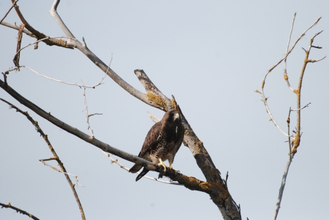
Birding is best on the refuge from October through March. Migrating and wintering species provide the greatest numbers and variety of birds. Refuge ponds are usually dry between May and August, mostly to control disease vectors that arise in the heat of the summer.
Mammals and reptiles can be difficult to find in the daytime, although ground squirrels and coyotes are frequently seen during daylight. Rattlesnakes, and side-blotched, whiptail and western fence lizards can also be easily observed during the day. The best time of year to observe wildlife is fall through spring. Refuge ponds are generally dry during the May through August period resulting in limited opportunities for wildlife observation.
Habitats
The Kern National Wildlife Refuge was established in 1960 by executive order as a wintering area for migratory waterfowl and other wetland dependant species. Of the 11,249 acres that comprise the refuge, approximately 5,000 to 6,500 acres consists of seasonal wetlands, irrigated moist soil units, and riparian riparian
Definition of riparian habitat or riparian areas.
Learn more about riparian habitat. In addition, uplands total about 3,600 acres and are made up of grassland, alkali playa, and valley sink scrub habitats.
Wetlands
Water is a critical component of wetland management, including not only quantity but also timing and availability. Early in the history of the refuge, water was supplied by deep wells or purchased annually from local water districts, but eventually both became cost prohibitive. It wasn't until 1992, when Congress passed the Central Valley Project Improvement Act that the refuge was provided with a reliable annual water supply.
All wetlands are seasonal in nature. Fall flood-up begins in mid-August and reaches a peak of nearly 6,500 acres of flooded marsh habitat by January. Habitat is maintained through February after which a slow draining of the wetland begins. Selected units are irrigated during the late spring and early summer months to encourage plants to grow to provide food for wintering and migrating birds the following fall.
Moist Soil Units
Wetland habitats are divided into moist soil and seasonal units. Moist soil areas, which comprise approximately 2,300 acres, are covered by shallow water depths (less than 6" deep). They are maintained by irrigation in the late spring and summer to encourage food plant growth. Swamp timothy, watergrass, and sprangletop typically grow in moist soil areas. Once every five years, moist soil units undergo a removal of all vegetation and a re-working of the soil to improve aeration and fertility.
Seasonal Marsh
Seasonal marsh units generally maintain water depths ranging form 4 feet to only a few inches and generally do not receive a summer irrigation. Cattail, hard-stem bulrush, burhead weed, alkali bulrush are plants typically found in these units.
Riparian
The refuge also contains some drier areas. Riparian areas are lush, filled with plants and trees that provide protective cover and nesting sites for many wildlife species. Willow and cottonwood trees provide shade and feeding areas for migrating birds, as well as year-round habitat for a host of aquatic animals.
Uplands
Uplands are not irrigated and primarily get their water form rain. These closed units, which occupy the northeast and northwest portions of the refuge, have been set aside for threatened and endangered species such as the San Joaquin kit fox, Tipton kangaroo rat, and the blunt-nosed leopard lizard.
Salt Cedar
Salt Cedar is a deciduous shrub native to Southern Europe into Mongolia, Tibet, Central China, and North Korea. It was first introduced in the United States in the early 1800s and has since become a major problem in many arid areas of the arid regions of the southwest. Prior to 1980, this invasive species invasive species
An invasive species is any plant or animal that has spread or been introduced into a new area where they are, or could, cause harm to the environment, economy, or human, animal, or plant health. Their unwelcome presence can destroy ecosystems and cost millions of dollars.
Learn more about invasive species was seen on the refuge as isolated plants. Floodwaters from the 1982-1983 flood year spread the highly viable seeds throughout the refuge. Currently 25 percent of the refuge is covered with salt cedar. Control methods range from mechanical removal coupled with herbicide treatment and foliar herbicide treatments.
Conservation
Refuge Planning
National Wildlife Refuge planning sets the broad vision for refuge management and the goals, objectives, strategies, and actions required to achieve it. Planning ensures that each refuge meets its individual purposes, contributes to the Refuge System’s mission and priorities, is consistent with other applicable laws and policies, and enhances conservation benefits beyond refuge boundaries.
Comprehensive Conservation Plans
Comprehensive Conservation Plans (CCPs) are the primary planning documents for National Wildlife Refuges. As outlined in the National Wildlife Refuge System Administration Act, as amended, the U.S. Fish and Wildlife Service (Service) is required to develop CCPs that guide refuge management for the next 15 years. CCPs articulate the Service’s contributions to meeting refuge purposes and the National Wildlife Refuge System mission. CCPs serve as a bridge between broad, landscape-level plans developed by other agencies and stakeholders and the more detailed step-downs that stem from Refuge CCPs.
The 2005 Final Comprehensive Conservation Plan for Kern and Pixley National Wildlife Refuges can be found here: https://ecos.fws.gov/ServCat/Reference/Profile/1444
Step-down Plans
CCP step-down plans guide refuge-level programs for: (1) conserving natural resources (e.g., fish, wildlife, plants, and the ecosystems they depend on for habitat); (2) stewarding other special values of the refuge (e.g., cultural or archeological resources, wilderness, wild and scenic rivers, etc.); and (3) engaging visitors and the community in conservation, including providing opportunities for wildlife-dependent recreation. Like CCPs, step-down plans contribute to the implementation of relevant landscape plans by developing SMART (Specific, Measurable, Achievable, Relevant, and Time-bound) objectives, strategies, implementation schedules, and decision support tools to fulfill refuge visions and goals. This ensures that refuges are managed in a landscape context and that conservation benefits extend beyond refuge boundaries.
Law Enforcement
Federal wildlife law enforcement celebrated its centennial in 2000 with the 100th anniversary of the Lacey Act - the Nation's first federal wildlife protection law. That Act's prohibitions on the importation of injurious wildlife and interstate commerce in illegally taken game species were followed by a series of measures aimed specifically at protecting migratory birds. With these laws and treaties came the age of the "duck cop." Policing waterfowl hunters and protecting waterfowl populations from commercial exploitation would long be a major focus for federal wildlife law enforcement.
During the middle decades of the century, however, increasing human pressures on populations and habitats of many different animals - from whooping cranes to American alligators - began to take their toll. Special protections for bald eagles (1940) and then golden eagles (1962) were put in place. The 1960s saw the first steps to protect a broader range of endangered species - steps that would culminate in the comprehensive 1973 Endangered Species Act and negotiation of the Convention on International Trade in Endangered Species of Wild Fauna and Flora (CITES). Laws to protect specific types of wildlife, from marine mammals and African elephants to wild birds and tigers, targeted special conservation concerns.
With these developments came new roles and responsibilities for Service law enforcement. From 1918 until the early 1970s, the word "game" consistently appeared in the job titles used for federal wildlife law enforcement officers. In 1973, however, the Service began calling its investigators "special agents," a name better suited to the expanding challenges of the job. In 1975, the Office of Law Enforcement hired a biological technician to inspect wildlife shipments in New York - the beginning of a trade inspection force that would expand the following year to cover eight ports of entry. The opening of the world's first wildlife forensics laboratory in 1988 made science and technology an integral part of the Service's enforcement team.
The Office of Law Enforcement today focuses on combating international wildlife trafficking, unlawful commercial exploitation of native species, environmental contamination, and habitat destruction. Partnerships with states, tribes, and foreign countries make Service special agents, wildlife inspectors, and forensic scientists part of a national and global network committed to protecting wildlife resources.
Laws and Regulations
All areas of the refuge are closed to the public unless otherwise explicitly posted as an auto tour route, nature trail, photo blind, or parking lot. Some areas are closed seasonally and are posted as such.
The following rules apply except where otherwise posted:
- Visitors to National Wildlife Refuges must comply with all applicable local, State, Federal regulations and signs.
- Hours- Visitation of the refuge is limited to posted hours.
- Fees- There are no fees to use the auto tour routes, nature trails, photo blinds, or parking lots.
- Permits- There are no permits required to use the auto tour routes, nature trails, photo blinds, or parking lots.
State/Federal permits are required for activities that are traditionally highly regulated (such as hunting or fishing) or otherwise prohibited. As an example, a refuge Special Use Permit (SUP) is required to enter closed areas or conduct activities that are otherwise prohibited (ex. wildlife trapping and tagging). For more information contact the refuge manager for the area where the proposed activity will occur at the Kern National Wildlife Refuge Complex Headquarters: (661)-725-2767.
Speed- Speed limit is 25 mph unless otherwise posted.
Open Areas- Areas open to public use will be posted as such. Road entrances to public use areas have a large brown sign, open gates, posted hours, or tour route signs. Areas open to the public include designated auto tour routes, nature trails, parking lots, and photo blinds.
Closed Areas- Areas closed to the public include all property that is not explicitly posted as an area open to the public including an auto tour route, nature trail, parking lot, or photo blind. Closed areas boundaries are posted along accessible areas with signs that may list the following: "UNAUTHORIZED ENTRY PROHIBITED", "AREA BEYOND THIS SIGN CLOSED All public entry prohibited." Visitors must stay our of posted closed areas. Visitors that enter posted closed areas are trespassing and are subject to law enforcement action including citations.
Permitted Activities:
- Use of posted auto tour routes, nature trails, parking lots, photo blinds.
- Pets on a leash when outside of vehicle
- Day use only
- Hiking along the auto tour routes only, watch out for traffic!!
- Bicycling along the auto tour routes only, watch out for traffic!!
Prohibited Activities:
All areas of the refuges are closed to public entry unless explicitly posted as a public use area. Visitors must comply with all posted rules and regulations, in addition to what is listed below, except where otherwise permitted/posted.
- No trespassing in posted closed areas
- No entry behind close gates or fences
- No night use
- No camping
- No travel off of designated public use road or trail
- No parking outside of designated parking lots
- No pets off leash when outside of vehicles
- No dog field trails or dog training that involves being off-leash
- No horseback riding
- No ATV's or UTV's
- No fires or cooking grills
- No weapons (except during lawful hunting activities and authorized by permit)
- No discharge of firearms (except during lawful hunting activities and authorized by permit)
- No take, disturbance, or collection of objects of antiquity or other valued objects
- No prospecting or mining
- No removal of any property from refuge
- No feeding wildlife
- No spotlighting
- No interference with persons engaged in authorized activities
- No drugs or alcohol
- No flying of drones or unmanned aircraft systems