


What We Do
Wildlife conservation is at the heart of the National Wildlife Refuge System. It drives everything on U.S. Fish and Wildlife Service lands and waters managed within the Refuge System, from the purposes for which a national wildlife refuge national wildlife refuge
A national wildlife refuge is typically a contiguous area of land and water managed by the U.S. Fish and Wildlife Service for the conservation and, where appropriate, restoration of fish, wildlife and plant resources and their habitats for the benefit of present and future generations of Americans.
Learn more about national wildlife refuge is established to the recreational activities offered to the resource management tools used. Using conservation best practices, the Refuge System manages Service lands and waters to help ensure the survival of native wildlife species.
Management and Conservation
The Crosby Wetland Management District administers the management actions for Lake Zahl National Wildlife Refuge, 99 Waterfowl Production Areas, and numerous wetland and grassland conservation easements. The district is part of the Northwest North Dakota Wetland Management District Complex. A project leader oversees the general management of all refuge lands within the complex, and refuge managers are responsible for using habitat management tools to best manage the lands for wildlife.
Livestock Grazing
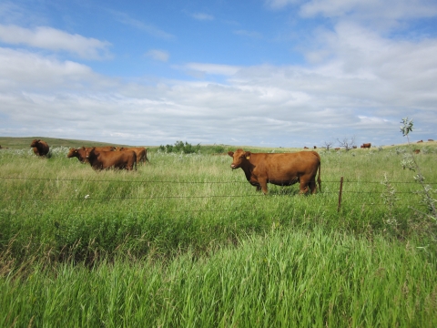
Herds of bison once grazed the grasslands of this region, greatly influencing the structure and composition of prairie communities. Grassland plants are adapted to disturbances caused by bison and other herbivores grazing, trampling, and depositing feces. As bison herds diminished, the composition of grassland plant and animal species began to change dramatically.
Today, cattle are used to mimic the effects of grazing bison. Grazing, based on the bison model, is now used to maintain a diverse and healthy prairie.
By varying the intensity, frequency, and timing of grazing, Refuge staff can target different plant species (such as invasive cool season grasses), reduce the amount of ground litter, and increase the structural diversity (range of heights and plant forms) of a prairie. This practice can be used to prepare ground for restoration, to increase the attractiveness for ground-nesting migratory birds and waterfowl, and to mimic a time when bison trampled and grazed large expanses of prairie.
Noxious Weed Control
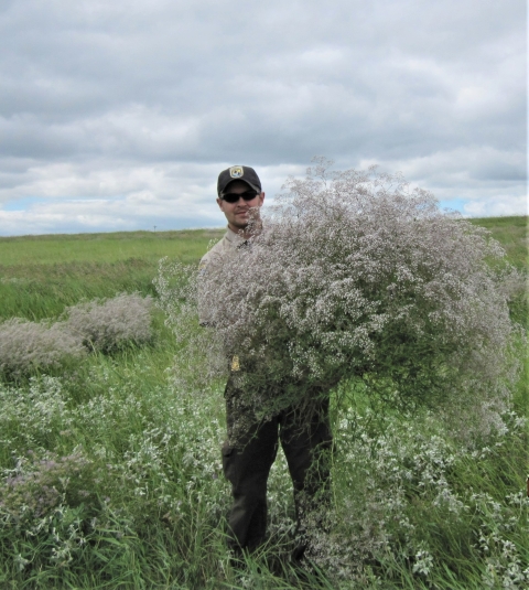
Invasive plants are a persistent threat to the native grassland and wetland ecosystems in North Dakota. The spread of noxious weeds has been difficult and expensive for refuge managers to control.
Canada thistle and leafy spurge are the top two noxious weeds by acreage in the Crosby Wetland Management District. Baby's breath, a popular ornamental plant often used in flower arrangements, is another invasive plant that has spread into the District.
Leafy spurge is perhaps the most difficult to control, requiring treatment beyond prescribed fire and grazing. Current techniques include herbicide application and biological controls.
Prescribed Fire
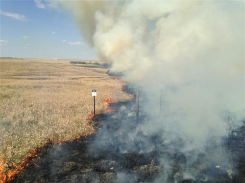
Historically, the North American prairies were subject to both regular fires caused by lightening and fires used as a hunting tool by Native Americans, in addition to short bursts of intensive grazing as huge herds of bison moved across the plains. Frequent fires maintained native grasslands by preventing most trees and shrubs from becoming well-established.
However, during the 1900's, these fires also destroyed the homes, possessions, and crops of European Americans. These settlers began preventing fires as much as possible, suppressing this natural process for more than 100 years. This allowed shrubs and aspen trees to expand over the prairie landscape, leading to changes in habitat and wildlife communities.
Over the years, changes in wildlife populations and habitat were recognized, and the importance of fire as a management tool became understood.
Fire is an important aspect of prairie restoration and maintenance. Refuge staff use prescribed burning to mimic the effects of natural fires and maintain the health of a prairie. Fire, when used correctly, removes vegetation litter, sets back the succession of invasive cool-season grasses, and stimulates new plant growth.
Our Services
At this field station we offer the following public services:
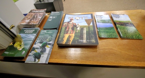
- A small contact station with local hunting and wildlife viewing information.
- Educational brochures, including a map of the Waterfowl Production Areas.
- Environmental education programs for local schools and groups (contact refuge manager).
- Administration of cooperative agriculture programs.
- Issuance of Special Use Permits.
- Project reviews related to energy development when U.S. Fish and Wildlife Service interests are involved.
- A Partners for Fish and Wildlife program for private landowners who are interested in conservation and funding opportunities on private land.

Our Projects and Research

Four-Square-Mile Survey
The purpose of the Four-Square-Mile Survey (FSMS) is to estimate the impacts of National Wildlife Refuge System lands on waterfowl breeding populations and production in the U.S. Prairie Pothole Region.
Each year, more than 100 cooperators from 25 participating U.S. Fish and Wildlife Service (USFWS) Wetland Management Districts conduct waterfowl surveys on sample wetlands within four square mile plots during two counts.
The first count occurs from May 1 to May 15, and the second from May 20 to June 5. Aerial photography is also collected at each plot to assess the wet area of all wetland basins within the plot boundaries.
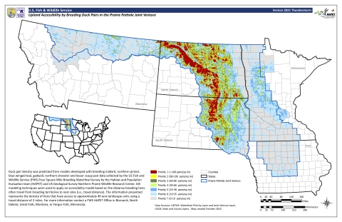
Field observations and aerial photography collected for the FSMS are used to develop models and decision-support tools that help improve waterfowl management. The breeding waterfowl upland accessibility map (commonly referred to as the “Thunderstorm Map”) is derived from FSMS data and illustrates the accessibility of upland nesting habitat to breeding hens. The USFWS realty program uses these and other tools to help identify priority areas for the acquisition of Waterfowl Production Areas and conservation easements.
Native Prairie Adaptive Management
The Native Prairie Adaptive Management (NPAM) program is a decision framework that was developed to address the degradation of native prairies caused by invasion of cool-season introduced grasses.
Participating management units occur across four states in the Northern Great Plans, averaging about 120 management units per year. Prairies enrolled in the NPAM program receive an annual management recommendation that is in part a result of the current state of the participating prairie units.
Management actions include resting, prescribed burning, grazing, or a combination of burning and grazing.
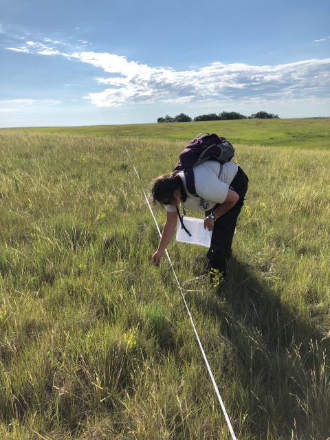
After the management is implemented, staff conduct vegetation surveys using the belt transect method to monitor the effects of the actions. The data collected from vegetation surveys inform the NPAM decision framework and help improve the annual management recommendations.
NPAM helps us implement science-based management of our individual management units, while leveraging learning that is taking place across all enrolled units.
Laws and Regulations

The U.S. Fish and Wildlife Service follows Federal laws, policies, and treaties passed throughout history. The passage and creation of laws and regulations, such as the National Wildlife Refuge System Improvement Act, ensures a strong and singular wildlife conservation mission. Click on the "Laws and Regulations" to learn about important acts that pertain to the Crosby Wetland Management District.