
What We Do
Bipartisan Infrastructure Law Bipartisan Infrastructure Law
The Bipartisan Infrastructure Law (BIL) is a once-in-a-generation investment in the nation’s infrastructure and economic competitiveness. We were directly appropriated $455 million over five years in BIL funds for programs related to the President’s America the Beautiful initiative.
Learn more about Bipartisan Infrastructure Law : 2022-2025 Klamath Basin Project Awards
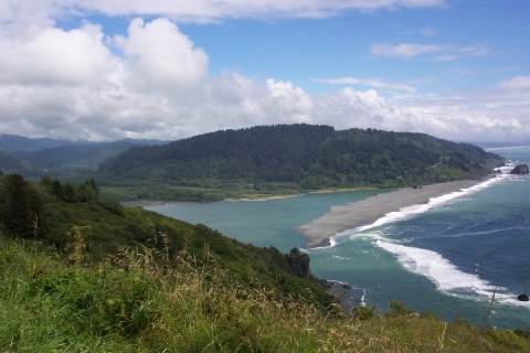
Through close collaboration and engagement with Klamath Basin stakeholders, Tribes, and federal, state and local leaders, the U.S. Fish and Wildlife Service has allocated almost $123 million in Bipartisan Infrastructure Law funds as part of the $162 million, five-year Bipartisan Infrastructure Law investment in the Klamath Basin. Funding will be used for ecosystem restoration activities and projects that address high-priority Klamath Basin water-related challenges in southern Oregon and northern California and for the expansion completion of the Klamath Falls National Fish Hatchery. The Hatchery works to enhance captive-rearing of Endangered Species Act-listed suckers that hold deep cultural significant for the Klamath Tribes.
The Service will continue to work with partners who are committed to finding long-term, collaborative solutions for the basin and its communities as the remaining funds are allocated in coming years.
Klamath Basin Project Awards
Project Name | Location | FY22 | FY23 | FY24 | FY25 |
Klamath Falls National Fish HatcheryThe Klamath Falls National Fish Hatchery investment will increase rearing capacity and help prevent extinction of two federally listed species found only in the Klamath Basin, the Lost River and shortnose suckers (C’waam and Koptu). This $30M will provide full funding to complete the construction of the hatchery, which is anticipated by 2027. Once the hatchery is completed, it will have the capacity to rear 60,000 suckers annually in support of the recovery of these highly imperiled species. | OR | $10,000,000 | $10,000,000 | $10,000,000 | n/a |
Yurok Tribal CapacityPartner: Yurok Tribe The Yurok Tribe Fisheries Department (YTFD) has made enormous contributions to the restoration of the Lower Klamath River Basin. This funding will add capacity so that the Tribe can continue to meet and expand its priority fish restoration efforts. The position will be funded for two years. | CA | $235,043 | n/a | n/a | n/a |
Waukell and Junior Creeks Culvert Replacements ProjectPartner – Resighini Rancheria Funds for this project will replace two undersized culverts, elevate roadways, remove invasive species invasive species | CA | $615,153 | $1,000,000 | n/a | n/a |
McGarvey Creek Restoration and Effectiveness MonitoringPartner: Yurok Tribe Funds will be used to maintain beaver dam analogue (BDA) sites within the McGarvey Creek watershed, and implement new, innovative restoration techniques in upper McGarvey Creek. Funds will also be used to assess restoration effectiveness of BDAs and other process-based restoration performance as a fisheries recovery tool and help guide and improve future restoration actions. | CA | $118,816 | n/a | n/a | n/a |
Terwer Creek Riparian Habitat EnhancementPartner: Yurok Tribe Funding will be used for riparian stewardship actions within lower Terwer Creek to improve habitat. Native trees and shrubs will be planted in key locations and vegetation will be monitored for survival and plant success within a two-mile reach of lower Terwer Creek. Promoting formation and maintenance of vegetated islands and healthy, resilient riparian forests is a priority ecological need and a focus of this project. | CA | $51,581 | n/a | n/a | n/a |
Ah Pah Creek Stream and Floodplain HabitatPartner: Yurok Tribe Funding will be used to design, plan for, and implement comprehensive stream and floodplain habitat enhancement actions within the Ah Pah Creek watershed. Proposed actions will focus on coordinating with a private timber company to reduce the footprint of floodplain roads and landings, installation of constructed wood jams, and promotion of side channel and backwater habitat formation and maintenance. The first phases of habitat enhancement will occur within the vicinity of the confluence with South Fork and mainstem Ah Pah Creek and reaches downstream. | CA | $202,246 | n/a | n/a | n/a |
Blue Creek Sanctuary Habitat Improvement and Bridge Crossing Replacement ProjectPartner: Yurok Tribe Funding will be used for improving stream and riparian habitats in the Yurok Tribe Blue Creek Sanctuary. Wood jams and other habitat structures will be constructed and installed. Off-channel and wetland habitats will be enhanced. Riparian treatments will be implemented in order to reduce invasive species impacts and increase native species productivity and resiliency. The project would also fund replacement of a bridge crossing West Fork Blue Creek that provides access to critically valuable habitats within this sub-basin and the upper reaches of Blue Creek. The existing bridge is unable to accommodate heavy equipment and thus needs to be replaced to facilitate watershed restoration and long-term stewardship within this vitally important sub-watershed. | CA | $393,823 | n/a | n/a | n/a |
Weitchpec Fisheries Research CenterPartner: Yurok Tribe Funding for the construction of the Weitchpec Fisheries Research Center, located on the Yurok Reservation in Weitchpec, CA. This building and site would consist of eight office spaces, a conference room, a laboratory, boat/equipment storage, work areas for technical staff, and would be a hub for Yurok Tribe Fisheries Department and the Yurok Natural Resources staff on the upper Yurok Reservation. This center will benefit the Yurok Tribe because of its remote location, and the additional data, restoration and monitoring that will result from the construction of this structure, will add to the body of scientific knowledge and restoration potential of the entire Klamath Basin. | CA | $1,619,434 | n/a | n/a | n/a |
Weaver Basin Improvement Planning ProjectPartner: Yurok Tribe Funding for this project will evaluate the feasibility of expanding upon existing Weaver Creek restoration plans with additional scope of work, design, and permitting analysis. Funds will be used to assess bridge and road improvement, recreational trail and green space development, integration with other surrounding restoration efforts in the Weaver Basin, and community development. This effort would help inform potential additional opportunities for habitat improvements. | CA | $160,338 | n/a | n/a | n/a |
Oregon Gulch Project on Mainstem Trinity RiverPROJECT COMPLETED. Partners: Yurok Tribe, Hoopa Valley Tribe, and Bureau of Reclamation Funding was used to supplement the removal of over 500,000 cubic yards of mining tailings to address intense disturbances to the Trinity River and valley caused by historical gold mining. During the period of upslope hydraulic mining in the late 19th century, mining debris washed off the hillslope buried the historical valley bottom, and subsequent dredging in the first half of the 20th century coupled with fluvial incision left a narrow canal-like channel with almost no functional floodplain area. This resulted in a section of river with extremely poor rearing, spawning, and adult holding habitat with pronounced limitations to rearing habitat capacity between frequent river flows of 450 cfs and 8000 cfs. The project site is located just below the Sheridan Riffle which has the highest density of natural spawning in the restoration reach of the main stem Trinity River. | CA | $735,465 | n/a | n/a | n/a |
Hospital Creek In-Stream Barrier Removal Design and Build ProjectPartner: Hoopa Valley Tribe Funding will be used to develop and implement engineered designs to create a passage over a barrier that, once removed, will allow the native salmonids and other species to move upstream. The Highway 96 crossing over Hospital Creek in Hoopa, CA is a complete upstream barrier to all salmonids and lamprey species for all stages of development at all discharges. Currently, the downstream end of the box culvert that Hospital Creek passes through has a perched outlet that prohibits fish from entering the culvert. Four large wood materials will be incorporated into the plans and be installed using locally sourced woody material and anchored using natural boulders. | CA | $249,681 | n/a | n/a | n/a |
Soctish Creek Fish Passage implementationPROJECT COMPLETED. Partner: Hoopa Valley Tribe Funding was used to restore fish passage over a diversion structure by creating a 200-foot-long roughened channel ramp by increasing stream bed slope from 2.1% to 3.6% below the diversion to meet the sill elevation at the diversion. The existing water supply diversion located around 898 m upstream from the confluence of the creek and the Trinity River was a complete barrier to adult and juvenile salmonid migration during low flow conditions, and temporal barrier during higher flow conditions. Soctish Creek is a perennial cold-water tributary to the lower Trinity River located entirely on the Hoopa Valley Tribe Indian Reservation in Humboldt County, CA. Four large wood debris features were installed using locally sourced woody material and anchored using natural boulders, providing additional habitat and channel complexity. This project also removed debris (old cars) that were used for bank stabilization by the Army Corps of Engineers following the 1964 flood. Soctish Creek supports spawning populations of Chinook salmon, coho salmon, steelhead, lamprey, and other native fish species as well amphibian species and other native wildlife. The creek is a primary refugia for non-natal rearing ESA-listed coho salmon. | CA | $194,503 | n/a | n/a | n/a |
Monitoring and Maintenance of Native Plant Installations on Mill Creek and Supply CreekPartner: Hoopa Valley Tribe Funding for this project will be used to install 5,000 native tree and shrub species to further bolster the native woody plant assemblage in riparian and floodplain, remove invasive plant species, including scotch broom and Himalaya berry from within the project sites, and establish monitoring transects at Mill Creek and Supply Creek to inform plant and species survival outcomes. The monitoring methods will be qualitative (via comparison of photo points over time) as well as quantitative (via line intercept transects that will be revisited in 2024 and 2026. With this data analysis, a more comprehensive understanding of which species thrive in which area(s) will be instrumental in guiding future revegetation efforts along the Trinity River and associated tributaries. Riparian vegetation is a crucial component of healthy salmonid-bearing streams; it contributes to cooler in stream temperatures that salmonids depend on by providing shade and cover, helps stabilize banks and prevent erosion, improves water quality by filtering sediment, contributes large woody debris (LWD), and serves as a major nutrient source for riparian flora and fauna. | CA | $81,340 | n/a | n/a | n/a |
Red Cap Creek & Camp Creek Floodplain RestorationPartner: Karuk Tribe Funds will be to complete design plans for approximately 1.75 miles of tributary habitat that will focus on improving instream habitat, increasing off-channel rearing habitat, enhancing thermal refugia, and reconnecting historic floodplains along these tributaries. These projects are focused on restoring habitat for ESA threatened coho salmon and will benefit all three species of salmonids present each of these tributaries. The outcomes of this project will be finished designs at two project sites, covering 1.75 miles of stream and 30 acres of floodplain habitat. Funds will also be used to purchase and store large trees with rootwads attached that will be used to create in-stream wood structures that are needed to restore in stream habitat at each of the project sites. | CA | $626,621 | n/a | n/a | n/a |
Karuk Tribe Spring-Run Chinook salmon Life Cycle MonitoringPartner: Karuk Tribe Funding for this project will help be used to collect data in the Mid-Klamath Basin for adult spring Chinook population trends at the adult life stage by engaging the local community in a watershed wide volunteer driven surveys and build community support for fisheries protection. Funds will also be used to monitor spawning distribution, timing, and habitat use, and to collect biological samples for analysis. Monitoring of juvenile Chinook distribution, utilization of in-stream habitats, juvenile relative abundance, fish health will also be performed. Understanding spring Chinook residency more fully will also help understand the impacts of climate change on these fish. | CA | $173,428 | $951,720 | n/a | n/a |
Karuk Tribe Water Monitoring Program in the Mid Klamath BasinPartner: Karuk Tribe Funding will be used to enhance the Tribe’s ability to quickly and efficiently respond to data requests, establish cohesive and structured storage of chemical data and physical water quality data. This project will address a data gap at the mouth of the Scott River and provide insights into how Ishi Pishi Falls functions as a hydraulic feature regarding fish migration. | CA | $151,901 | n/a | n/a | n/a |
Beaver Creek Helicopter Wood Loading ProjectPartner: Mid-Klamath Watershed Council Funding for this project will help improve conditions for native fish and other aquatic species. Using a helicopter, this project will add 120 pieces of large wood to 2-1/2 miles of West Fork Beaver Creek in Siskiyou County, on privately owned land. These large wood structures will restore structure, spawning and rearing habitat, and floodplain connectivity. The wood structures will provide immediate benefits to native fish by providing cover and areas of low velocity habitat. Target species that will benefit from this project are Chinook salmon (fall-run), coho salmon, steelhead (spring/summer and winter), and Pacific lamprey. With dam removal on the horizon, this project is anticipated to benefit spring-run Chinook salmon as well. This project is needed because current and past land management practices including logging streambanks, road and berm building, extirpation of beavers, fire suppression have channelized streams within the Klamath Basin. | CA | $591,798 | n/a | n/a | n/a |
Quartz Valley Integrated Hydrological ModelPartner: Quartz Valley Indian Reservation Funding for this project will be used to improve the understanding of the integrated surface water and groundwater system in the Quartz Valley so that the Quartz Valley Indian Reservation and other water managers can effectively manage their limited water supplies. The Quartz Valley uses both surface water and groundwater to meet their water needs. Because the surface water system is fully allocated, the Quartz Valley has been relying more on groundwater to meet its increasing demands for water. Past studies have recognized the interconnection between groundwater and surface water in the Scott Valley (Hathaway, 2012), and the groundwater and surface water systems are likely connected in the Quartz Valley as well; however, this interconnection was not recognized in the adjudication and presently there are no limitations on groundwater usage. The increased use of groundwater is a major concern in the Quartz Valley. Four of the QVIR tribal wells have gone dry in recent years, which has caused concerns about available drinking water. There have also been water quality issues, including E. coli contamination. This funding will be used to develop the Quartz Valley Integrated Hydrologic Model (QVIHM). This model will build upon a groundwater model of the entire Scott River Valley Groundwater Basin called the Scott Valley Integrated Hydrologic Model, which was developed and is being maintained by a team at UC Davis to support the Scott Valley Groundwater Sustainability Plan. The QVIHM can be used to help identify strategies to help restore flows in the surface water system and restore salmon habitat in Shackleford Creek. Analysis of groundwater flow paths and other model outputs will help water managers identify management strategies to improve water quality issues. | CA | $455,203 | n/a | n/a | n/a |
Shackleford Creek Habitat RestorationPartner: Quartz Valley Indian Reservation This project will collect the necessary survey and groundwater data, develop a 2-D hydraulic model, assessing relevant reference projects, and conduct a bioassessment to inform the restoration design of nearly a mile of an incised Coho and Steelhead stream in the Scott River Valley. The project will produce an adaptive management plan that documents the restoration strategy, a monitoring plan to measure project success, and a CEQA Initial Study to initiate the necessary environmental clearance. The restoration goals of this project are to increase hydraulic residence time and expand floodplain flows to increase floodplain infiltration and raise the groundwater table. This will lead to the colonization of riparian vegetation, longer and more consistent summer stream flows, and improved fish passage. The implementation of treatments and their locations determined through the planning process and will take advantage of specific opportunities on site. Treatments will include the use of large wood, root wads, felled trees, permeable woody debris dams, live cuttings, and bioengineering treatments. | CA | $202,396 | n/a | n/a | $244,821 |
Sugar Creek Coho Salmon Refugia ProjectPartner: Scott River Watershed Council Funding for this project will be used to connect one acre of slow, cold-water refugia rearing habitat to one acre of floodplain habitat constructed in an earlier phase of this project. When complete, this project will result in a total two acres of new high quality rearing habitat for juvenile coho salmon, and connects Sugar Creek, a key Scott River watershed spawning and rearing stream, to the new habitat. The purpose of this project is to increase the production of Scott Watershed coho salmon, a native fish population that has been deemed hatchery influence free by NOAA, thereby supporting down listing of the species. The new permanent cold water rearing areas have been designed to withstand climate change and drought, and also provide rich food resources that allow juvenile fish to thrive and grow large, even as ambient and stream temperatures rise, thereby increasing survival into adulthood. The project builds on 10 years of restoration actions, and associated effectiveness monitoring, within Sugar Creek that demonstrated a thousand-fold increase in juvenile coho production over pre-restoration conditions. | CA | $861,000 | n/a | n/a | n/a |
Development of models for predicting annelid hosts in the Klamath River Hydroelectric ReachThis funding will be used to test and refine predictive models for annelid hosts in the Klamath River hydroelectric reach, which will inform and improve management decisions in the Klamath Basin. High annelid host densities, which are linked to fish disease in the Klamath River, have been described in the J.C. Boyle Bypass and Keno reaches of the Klamath River hydroelectric reach. Understanding the factors driving annelid host distribution and density in the hydroelectric reach is critical to the success of salmon recovery and future habitat restoration efforts. A predictive model was previously developed for annelids located in the current infectious zone, downstream from Iron Gate Dam. The model has been used to predict the distribution and density of infected annelids and evaluate effects of managed flow events downstream from Iron Gate Dam. This approach can be applied in the hydroelectric reach, however model performance should first be evaluated because the model may require refinement due to the unique hydraulic and sediment conditions that characterize the Klamath River hydroelectric reaches. The proposed work will build on the previous model to 1) test and refine our understanding of relationships between flow variability and the distribution and relative abundance of M. occidentalis in various habitat types, 2) contribute to a long-term data set quantifying the conditions leading to the presence of annelids and C. shasta infection, and 3) provide a tool for evaluating the potential successes proposed of flow-control or habitat restoration actions (e.g., gravel augmentation) targeted toward salmon habitat in the Klamath River hydroelectric reach. or habitat restoration actions. | CA and OR | $147,117 | n/a | n/a | n/a |
Fringe Wetland Restoration Master Plan for The Keno Reach of the Klamath RiverPartner: Klamath Watershed Partners Funding for this project will be used to develop a master plan to restore, develop and expand wetlands to the Keno Reach of the Klamath River. Following dam removal on the Klamath River, salmon and steelhead are expected to return to the Upper Klamath Basin. The “Keno Reach” has severe water quality problems. The plan will also identify opportunities for the construction of diffuse source treatment wetlands to locally treat agricultural runoff from adjacent agricultural drains. An analysis of existing topographic and bathymetric data in the project reach will be performed to identify areas where fringe wetland creation, restoration, and/or enhancement are possible. The project team will then initiate an outreach effort to landowners along the project reach to gauge interest in future participation in wetland restoration/enhancement projects. Data from these first tasks will be captured and stored in a database that serve as the basis for future wetland project development. This will include high-resolution topo-bathymetric data collection following a controlled burn in the spring of 2023, evaluation and modeling of site hydrology, and identification of alternatives for improving water circulation through the existing wetlands. The project team also intends to partner with the Tule Smoke Hunt Club to evaluate wetland enhancement and restoration opportunities on club property. | OR | $903,075 | n/a | n/a | n/a |
Improving Wetland Habitat through Irrigation Efficiencies on Lower Klamath and Tule Lake National Wildlife RefugesPartner: Ducks Unlimited Funding for this project will be used for the construction of four pumping stations, two each in both Lower Klamath National Wildlife Refuge and Tule Lake National Wildlife Refuge. Together, these pumping stations will improve water supply reliability and functionality on over 20,000 acres of wetland habitat on both Refuges, while also improving irrigation efficiency, by providing flexibility in management and decreasing operational costs for over 20,000 acres of irrigated agriculture. | OR and CA | $2,668,147 | n/a | n/a | n/a |
Upper Klamath Lake Shoreline Sucker Spawning HabitatPartner: Klamath Tribes Funding is for the Klamath Tribes to monitor Lost River sucker spawning and success of Reclamation-funded projects that were designed to enhance sucker spawning sites. A population of Lost River suckers spawn exclusively at eastern shoreline springs in Upper Klamath Lake (UKL). Most of these springs have been degraded by alterations to the surrounding area including development of the railway and highway adjacent to the shoreline of the lake. Current Lost River sucker spawning is restricted to four small shoreline spring areas including: Sucker, Ouxy, Cinder Flat, and Silver Building. Due to on-going drought conditions only Sucker Springs has substantial spring discharge and large numbers of spawning fish. Since all of the spawning areas are located in shallow shoreline areas, they are greatly affected by lake levels. The Klamath Tribes will implement additional spawning habitat enhancement activities at other springs along the shoreline of Upper Klamath Lake. If there is no spawning documented at the pilot spawning habitat enhancement sites, strategies will be developed for getting fish to imprint and spawn at these sites. | OR | $50,000 | n/a | n/a | n/a |
Restoration of the Barkley Springs ComplexFunding will be used for project engineering designs and project implementation. Funds will also be used to develop a post-project monitoring plan. Barkley Springs is the largest of six spring complexes on the east side of Upper Klamath Lake (UKL). Historically, a population of Lost River suckers spawned at the springs until the 1970s when access to the springs was blocked by development of Hagelstein County Park. A fish habitat restoration project was completed in 2010 resulting in the construction of a meandering stream channel connecting a large spring pond to the adjacent lake channel. This project resulted in suckers and redband trout gaining access to the spring pond for rearing. Based on the success of the first restoration project there is additional habitat that could be restored. | OR | $150,000 | n/a | n/a | n/a |
Williamson River Delta Preserve (WRDP) Phosphorus Capture PotentialPartner: Klamath Tribes Upper Klamath Lake (UKL) is the primary habitat for the endangered Lost River sucker and shortnose sucker. The Sprague and Williamson rivers are a major source of nutrient loading to UKL. Reduction of nutrient loading to UKL, particularly phosphorus has been identified as an important means of improving water quality affecting endangered suckers, as well as reducing the export of organic matter and nutrients to the Klamath River downstream of Upper Klamath Lake. This proposal addresses Recovery Action 2 in the Revised recovery plan for the Lost River sucker and shortnose sucker. This project would include short-term water quality data collection, assessment, and modeling to inform a new management approach, namely whether portions of the WRDP can contribute to reductions in external Phosphorous loads and thus improve water quality. Phosphorus removal estimates will be done using hydraulic/sediment transport modeling and 2D and lake-circulation modeling. | OR | $200,000 | n/a | n/a | n/a |
Lower Williamson River Bothwell Property Spawning Gravel Augmentation and Large Wood Placement ProjectFunding for this project place large wood into the Williamson River to address limiting factors that affect spawning and juvenile rearing habitat of native fish. The project goals include augmenting spawning habitat and increasing juvenile redband trout rearing capacity in 1.4 miles of the Williamson River centered on the Spring Creek confluence. The Bothwell property is a privately-owned 176-acre parcel that is the last large private property before an extended reach of the Williamson River that is managed by Oregon Parks and Recreation Department and the U.S. Forest Service. Large wood has been placed throughout the Williamson River in the upstream publicly managed reach. The Bothwell Family manages their property for wildlife habitat, and other than impacts from the “242 Fire” in 2020, the floodplain is in a natural condition unaffected by grazing, diversions, or deleterious physical modification. The proposed project treatments and the addressed limiting factors are highlighted in recent planning documents including The Upper Klamath Basin Watershed Action Plan (Skinner et al. 2021) and the Klamath Basin Integrated Fisheries Restoration and Monitoring Plan (ESSA 2022). Spawning gravel augmentation and large wood placement are anticipated to immediately benefit redband trout, and will help future runs of salmon, steelhead and pacific lamprey into the Upper Basin. Oregon Department of Fish and Wildlife will include the project reach in their bi-monthly redband trout spawning monitoring program. | OR | $225,576 | n/a | n/a | n/a |
Klamath Tribes Sucker Rearing program expansionPartner: Klamath Tribes The Klamath Tribes have successfully increased their endangered Lost River and shortnose sucker rearing program, adding additional ponds, raising fish from eggs, conducting staff professional development, and continuing to develop a systematic approach to rearing suckers. These funds will help to expand operations to include an additional 10-15 ponds) and provide the Tribe with the capacity to eventually release fish to supplement dwindling wild populations. | OR | $875,061 | n/a | n/a | n/a |
Klamath Tribes Salmon Reintroduction programPartner: Klamath Tribes Funding will be used to help the Klamath Tribes jumpstart the return of salmon to the Upper Klamath Basin. The Klamath Tribes have not had access to native Klamath River salmon fisheries for more than 100 years. This funding will help the Tribe institute a program so they can rear Chinook salmon eggs and larvae with a state of art salmonid egg rearing system. By rearing, tagging, and releasing smolts, the Tribes will identify migration patterns, important habitat, and any potential issues that may arise when salmon naturally return. The Tribes will install an upgraded recirculating aquaculture system that uses minimal water and has no discharge to surface water. This project provides for the development of a salmon reintroduction program consistent with the exercise of tribal fishing rights. | OR | $913,786 | n/a | n/a | n/a |
Sprague Watershed Low-Tech Process-Based Restoration CollaborationPartner: Trout Unlimited Funding for this project will be used to implement Low-Tech Process-Based Restoration techniques (which include Beaver Dam Analogs, Post Assisted Woody Structures, and other similar structures) throughout the Sprague River Watershed in order to reduce sedimentation, increase groundwater storage, and improve habitat conditions. The Sprague River Basin provides critical spawning and rearing habitat for native fish, including ESA listed Bull Trout and Lost River and shortnose suckers, yet suffers extensively from geomorphic and hydrologic impairments that reduce habitat quantity and quality (e.g., floodplain disconnection, lack of channel complexity), as identified in the Upper Klamath Basin Watershed Action Plan (UKBWAP) and the Integrated Fisheries Restoration and Monitoring Plan (IFRMP). In addition, the Bootleg Fire burned through much of the Upper Sprague Basin in 2021 and exacerbated many of the issues already present, especially the lack of riparian habitat and excessive sedimentation. Recognizing these impairments and the need for collaborative watershed-scale restoration to achieve ecological uplift, the overall goal of the proposed project is to restore self-sustaining riverine processes in degraded stream reaches of the Sprague River Basin using LTPBR implemented by local crews. | OR | $231,714 | n/a | n/a | n/a |
Climate Change Resiliency Stream Restoration and Post-Bootleg Fire Stream Stabilization and RestorationPartner: Klamath Tribes Poor land and water management in the Upper Klamath Basin over the last century has resulted in degradation of wetland, upland, riparian and aquatic habitats. Specifically, loading of nutrients into waterways, damage to riparian corridors, channelization of streams and rivers, disconnection of river channels and floodplains, insufficient stream flows, impediments to fish migrations, draining of wetlands and other ecosystem damage have profoundly impacted natural resources important to the Tribes. Treaty-guaranteed fisheries have declined or been lost including the endangered C’waam (Lost River sucker), Koptu (shortnose sucker), redband trout, and salmon. Many non-aquatic resources greatly valued by the Tribes (water quality, wocus, and other species) have declined. The proposed project includes elements of surveying, project design, environmental compliance, and on-the-ground implementation. Specific restoration actions will include, use heavy equipment and manual labor to place approximately 400 Beaver Dam Analog, Post Assisted Log Structures, and other types of instream structures in several streams in the Sprague River and Williamson River watersheds. Crews will also install several miles of buck and pole riparian fencing to protect restored stream sections, as well as remove encroached lodgepole pine from meadow complexes in the Upper Klamath watershed. Most of this work will take place in the Sprague River and Williamson River watersheds. | OR | $807,086 | $922,459 | $3,179,400 | n/a |
Restoration of the Upper Williamson River including Rocky Ford RanchPartner: Klamath Tribes Funds for this project will be used to achieve site surveys, geomorphic assessment, hydrology and hydraulics analysis, engineering design drawings, environmental compliance, and development of a pre- and post-project monitoring plan. The Upper Williamson River above the Klamath Marsh has been degraded from past grazing management practices that have resulted in loss of riparian vegetation, bank erosion, increased sedimentation, channel incision, and disconnection with the floodplain. As a result, late season base-flows are lower than they were historically, floodplain areas dry out as a result of the lower groundwater levels and riparian vegetation can’t get established. This project will help restore this important reach in the Upper Basin. | OR | $500,000 | n/a | n/a | n/a |
Klamath Basin Fisheries Collaborative: Passive Integrated Transponder (PIT) Tag Monitoring and Database ProjectPartners – Pacific States Marine Fisheries Commission, Karuk Tribe, Klamath Tribes, Yurok Tribe, and Scott River Watershed Council The PIT Tag coalition is a collaborative effort to develop a basin-wide fish tracking infrastructure to monitor the success of restoration efforts in the Klamath Basin. A comprehensive PIT infrastructure and integrated upper and lower basin database have been identified as a basin-wide priority. This project integrates scientifically rigorous localized research to create a data network capable of addressing questions at multiple spatial and temporal scales. Data collection will focus on spring and fall Chinook Salmon, and endangered suckers, but may include nearly all migratory fishes in the Klamath Basin. This data will be critical for analysis used to inform potential future downlisting or delisting of ESA-listed species. Data will provide the ability to track the relationship between juveniles and returning spawners. | OR and CA | $1,198,378 | $1,146,218 | n/a | $1,253,000 |
Sprague River Collaborative RestorationPartners – Upper Klamath Basin Ag Collaborative, The Klamath Tribes, Sustainable Northwest, Klamath Watershed Partnership, Trout Unlimited, Soil and Water Conservation District, Intermountain West Joint Venture, Oregon Agricultural Trust, and Resource Environmental Solutions (RES) This projectwill provide instream and floodplain restoration along 26 miles of headwater streams in the Sprague River Watershed, develop cost-level design plans and baseline monitoring for instream and floodplain restoration of the mainstem Sprague River, and develop a landowner incentive program to encourage landowner participation in restoration programs and retain economic viability for family farms and ranches. The Sprague River Collaborative Restoration Project emphasizes a commitment to voluntary, incentive-based approaches and identifies the critical role of Tribal and working lands to ecosystem restoration.This project also stresses the importance of supporting Indigenous knowledge and sovereignty and landowners’ interests and rights, with the support of federal, state, and local conservation programs. | OR | n/a | $3,000,000 | $3,000,000 | n/a |
Ecological Restoration of the Blue Creek Salmon Sanctuary ProjectPartner - Yurok Tribe This project will focus on stream enhancement roadway and stream crossing improvement and decommission. It will also focus on brush reduction, and development of the Blue Creek Sanctuary Riparian Stewardship Plan. These restoration activities within the Blue Creek Sanctuary and adjacent conservation areas promote recovery and sustainability of native fish and wildlife populations, increase ecosystem health and resiliency in support of native species, and support Yurok cultural lifeways. | CA | n/a | $3,000,000 | n/a | $1,000,000 |
Upper Williamson River RestorationPartner: Klamath Tribes Funding will be used for restoring the historical hydrology within the Klamath Marsh through the removal of TPC, Middle, and House bridges and restoration of roughened channels. Additionally, the Cholo Diversion will be demolished and replaced with a horizontal flat plate screen and headgate structure. These restorative efforts will improve habitat for resident fish, wildlife and migratory species, and remove barriers to fish passage. Phase 2 (FY25 Funding) Partners: Ducks Unlimited and The Klamath Tribes This project will provide fish passage to over 26 miles of the upper Williamson River and reconnect several thousand acres of adjacent wetlands and riparian habitats within the Klamath Marsh National Wildlife Refuge project area. Existing irrigation infrastructure and hydrologic modifications, including delivery ditches, drains, and levees, currently limit fish passage and floodplain connectivity, alter timing and duration of flooding, hinder volitional movement of native fish species, and restrain the storage capacity of the Klamath Marsh. Funds will be directed to the removal of existing irrigation infrastructure, installation of fish screens, and creation of roughened channels for fish passage. | OR | n/a | $2,000,000 | n/a | $3,500,000 |
Supply Creek Levy Setback and Floodplain RestorationPartner – Hoopa Valley Tribe After the 1964 flood, the U.S. Army Corps of Engineers constructed high artificial berms on both banks of Supply Creek, disconnecting it from its former floodplain and impacting salmonid habitat. This implementation-ready project aims to reestablish a complex, naturally functioning stream corridor with a restored riparian overstory by removing the constructed berms and reconnecting Supply Creek with its former floodplain. This effort will create habitat and support long-term natural physical and biological stream processes. A current BIL funding award of $1.5 million will complete work in 2024 on relocating Scale Shack Road that fronts Supply Creek, paving the new road location to decrease sediment runoff, creating a storm swale, and completing some floodplain rehabilitation on the east end of the project area. With this additional funding request, the plan is to remove 100 meters of berm downstream of Loop Road and decommission the dilapidated septic system, leach field, and associated infrastructure. These actions will enable future projects to transform these areas into floodplain and off-channel habitats. The proposed project aligns with recommended state and federal recovery actions by removing channelization and levees, reconnecting the channel to a restored floodplain, increasing short- and long-term large wood loading, implementing riparian revegetation, and creating off-channel side channels and ponds for coho refugia. Removing the constructed berms and reconnecting Supply Creek with its former floodplain. This effort will create habitat and support long-term natural physical and biological stream processes. | CA | n/a | $1,500,000 | n/a | $2,624,599 |
Mid Klamath Coho Salmon Spawner Survey ProjectPartner – Karuk Tribe Funding will focus on maintaining and expanding the understanding of Coho Salmon population distribution and habitat utilization and examining restoration effectiveness to support well-informed management decisions and restoration actions. These monitoring efforts are needed to make sound management decisions regarding Coho within the Klamath Basin, especially in consideration of dam removals and their potential downriver effects. | CA | n/a | $368,280 | n/a | n/a |
Upper Horse Creek Valley Channel Restoration ProjectPartner – Mid Klamath Watershed Council Funding will be used for the restoration of the Upper Horse Creek Valley Channel. The project will create 1,500 feet of a new channel with increased sinuosity, side channels, off-channel ponds, and 37 Beaver Dam Analogues to 0.75 miles of Horse Creek and 6.5 acres of adjacent riparian area. These efforts will benefit Chinook and Coho salmon, steelhead, Pacific lamprey, and other aquatic species by increasing spawning and rearing habitat, which remain a limiting factor to the survival and growth of these species. | CA | n/a | $899,572 | n/a | n/a |
QVIR Scott River Basin Data Collection ProjectPartner – Quartz Valley Indian Reservation Funds for this project will establish a comprehensive network of up to 30 discharge (instream flow) stations, both telemetered and continuous. Each tributary has different qualities for fisheries needs, and the data from the discharge stations can capture flows at every level. The Scott River tributary's water inputs, especially above diversions, will increase the accuracy when estimating the water budget. This data will inform water and fisheries management along with several watershed projects currently underway. | CA | n/a | $999,948 | n/a | $36,200 |
Agency-Barnes Wetland RestorationPartner: Upper Klamath National Wildlife Refuge Funds will be used to initiate wetland restoration activities within the Barnes and Agency Units of Upper Klamath National Wildlife Refuge. Interior levees will be removed and fish refugia areas and migratory bird habitat will be constructed in preparation for levee breaching in late 2024. The Barnes and Agency project is one of the largest wetland restoration projects in the U.S. and will result in: the restoration of valuable lake fringe wetlands on Upper Klamath Lake benefitting a multitude of fish and wildlife species, increases in water storage, enhanced public use opportunities. | OR | n/a | n/a | $3,500,000 | n/a |
Wetland Restoration on Upper Klamath Basin National Wildlife RefugePartners: Ducks Unlimited and The Klamath Tribes This funding will be used to complete restoration of the Agency-Barnes wetland units of Upper Klamath National Wildlife Refuge (NWR) and provide fish habitat access in Fourmile and Sevenmile creeks. This project is a priority for both the Service and the Klamath Tribes, which is a party to the MOU. Covering 14,356 acres, the restored wetland will create vital habitat for waterfowl, federally endangered Lost River and shortnose suckers, and other species, making it one of the largest wetland restoration initiatives in the United States. | OR | n/a | n/a | $13,000,000 | n/a |
Mid Klamath River Habitat ProjectPartner - Karuk Tribe Funds will be used to advance restoration in the Mid-Klamath River area and will increase the viability and production of the mid- and upper- Klamath River population of coho salmon by increasing the availability of suitable habitat for natal and non-natal salmon within the project area. The objectives are to increase habitat availability and improve instream habitat conditions by installing large wood structures that will slow water velocity, increase habitat complexity, retain and sort spawning gravel, provide cover, provide substrate for fish prey, and re-connect the channel to historic off-channels habitats on the adjacent floodplain. Specifically, funds will be directed toward the China Creek Helicopter Wood Loading project which will result in the placement of 100 to 120 logs. Funding for the West Fork Beaver Creek Helicopter Wood Loading project will add logs with root wads attached to 4,000 feet of the stream, within 18 acres. Additional funding will be used to restore stream channels and floodplains on Middle Creek and Buckhorn Creek, which are two important tributaries to Horse Creek. These projects aim to restore channel form and function to approximately 1,000 linear feet of Middle and Buckhorn Creeks, provide approximately 9,000 square feet of off-channel rearing habitat, and restore riparian floodplains through grading and native plant revegetation and invasive species removal. | CA | n/a | n/a | $1,150,000 | n/a |
Lower Junior Creek Restoration 65% to Final DesignPartner: Pulikla Tribe of Yurok People (formerly Resighini Rancheria) Junior Creek is a tributary to Waukell Creek, which flows into the Klamath River estuary. Previous fisheries monitoring has identified Junior Creek as providing low-velocity habitat for over-wintering juvenile coho salmon and numerous other aquatic organisms. However, much of the stream corridor is degraded due to excess sediment inputs from tributaries and an infestation of invasive reed canary grass (RCG) that clogs waterways and degrades water quality. This project's objective is to develop final (100%) engineered plans, specifications, and a cost estimate (PS&E) for restoration of the lowermost 450 feet of Junior Creek to its historical location on the landscape. In addition, funding will be used to obtain all required permitting to facilitate further funding for construction of the project and a post-project revegetation plan. | CA | n/a | n/a | $362,914 | n/a |
Tule Lake Flow Through Infrastructure ImprovementPartner: Klamath Water Users Association/Tulelake Irrigation District This project encompasses a suite of infrastructure improvements and operational changes to provide natural ecosystem services with respect to water quality in the Klamath Basin. Water used for farmland irrigation would then flow through wetlands before returning to the Klamath River. In addition to water quality benefits for the Klamath River, this project will provide habitat for threatened and endangered fish, support migratory wildlife, recharge groundwater, and provide other ecosystem benefits. | OR | n/a | n/a | n/a | $2,540,000 |
Surface Water Management and Efficiency EnhancementPartner: Klamath Water Users Association/Klamath Drainage District/Klamath Irrigation District This project encompasses necessary infrastructure improvements to allow safe, reliable, and integrated management of water within the Klamath Project. Largely constructed between 1906 and 1957, the Klamath Project includes 185 miles of main canals, 680 miles of lateral canals, and 728 miles of drainage ditches. These facilities are primarily operated and maintained by KID, TID, and KDD. Over the past several years, these districts have been engaged with FCA on modernizing and increasing the efficiency of existing irrigation infrastructure. FCA planning for each of the districts is being done in accordance with Public Law (P.L.) 83-566, in anticipation of funding being made available through the U.S. Department of Agriculture Natural Resources Conservation Service (NRCS). Additionally, FCA has been awarded a grant by Reclamation to identify, plan, design, and install equipment within the Klamath Project to allow for supervisory control and data acquisition (SCADA). FCA is currently coordinating with the districts about the implementation of this grant. KID is also currently partnering with a private company to evaluate opportunities for developing low-head hydropower generation on existing irrigation infrastructure. | OR | n/a | n/a | n/a | $295,000 |
SONAR and Radio Telemetry and Spawning Surveys for Klamath SalmonPartners: Karuk Tribe in collaboration with California Trout, the Klamath Tribes, Yurok Tribe, Cal Poly Humboldt and CDFW Funding will be used to obtain abundance estimates of salmon and steelhead entering the reach previously blocked by the four Klamath River hydroelectric dams, which were removed in 2024. The project will track salmon migrations to their spawning grounds. These metrics will provide a foundation for assessment of stock status and trends while guiding future restoration efforts in the newly accessible habitats, developing a toolset to support prioritization of future restoration and monitoring in the Klamath River. Additionally, this project will also provide much needed capacity for three of the six tribes on the Klamath River, allowing them to track the return of these culturally significant species after a century of exclusion while providing tribal scientists monitoring skills and employment opportunities working on this monumental project. A portion of the funds will be used to purchase SONAR equipment and for running the monitoring station, trap netting, and other telemetry infrastructure in support of spawning surveys and thermal refugia surveys. | CA | n/a | n/a | n/a | $2,027,799 |
Upper Shasta River Salmon Habitat Restoration ProjectsPartners: Karuk Tribe in collaboration with California Trout, and The Nature Conservancy, and Yurok Tribe Funds will be used to develop plans for large scale salmon habitat restoration projects in the upper Shasta River Valley. The Tribe will work with willing landowners and conservation partners to restore parts of Parks Creek, Big Springs Creek and Hole in the Ground Creek. These tributaries to the Shasta River are prioritized for habitat improvement projects and include enhancement of cold-water springs, spawning habitat and fish passage. Projects scheduled for implementation in 2025 include fish passage into Little Springs Creek Lake and low-tech Beaver Dam Analog and wood structures in Big Springs Creek. Habitat restoration planning and project engineering and design is slated for Parks Creek. | CA | n/a | n/a | n/a | $2,886,291 |
Scott River Habitat Restoration – Strengthening Resiliency of Farms and FishPartners: Yurok Tribe in partnership with Karuk Tribe, California Trout, Farmers Ditch Company, and Scott River Water Trust The Scott River supports the largest cohort of state and federally threatened wild coho salmon in California. However, seasonally low stream flows through the upper reach of the mainstem Scott River prevent access to vital headwater tributaries. This project will focus on recovery activities that enhance and extend surface flow connectivity to ensure sufficient instream flows are given priority, along with efforts to increase summer and winter rearing habitat that reduce lethal stream temperatures and fine sediment mobilization. | CA | n/a | n/a | n/a | $1,850,000 |
Weaver Creek Habitat RestorationPartners: Yurok Tribe in partnership with Nor-Rel-Muk Wintu Nation Funding will be used to for implementing restoration actions associated with the Weaver Creek Habitat Restoration Implementation Project. Funds will be used to create instream habitat and new floodplain areas along a one mile section of Weaver Creek. These actions will significantly increase the amount of instream habitat for coho salmon that are listed as federally, and state threatened; improve riparian habitat while controlling the spread of invasive plant species; and ensure a single threaded wet channel during summertime baseflow conditions so that water is likely to remain available instead of going subsurface or evaporating. The proposed work would result in construction of numerous new habitat features including approximately 5.12 acres of floodplain, 1.23 acres of overflow channel, 0.82 acre of constructed riffle, 0.40 acre of channel fill, and 0.36 acre of low flow channel. | CA | n/a | n/a | n/a | $4,542,000 |
Junior Creek Wetlands - Fisheries Monitoring and Tribal Capacity Building ProjectPartners: Pulikla Tribe of Yurok People (formerly Resighini Rancheria) This proposed fishery monitoring project will quantify coho smolt production in Junior Creek for three years prior to implementation of restoration designs that are currently under development. Establishing a robust pre-restoration baseline will allow us to investigate restoration effectiveness over time, given that monitoring continues post-restoration. We will also gain an enhanced knowledge of juvenile coho habitat use, growth and survival rates through the incorporation of pit tagging efforts at upstream and downstream migrant trap sites. And as conditions within the Klamath River Basin change in the near term with dam removal and in the longer term from the uncertain effects of climate change, the importance of Junior Creek and Waukell Creek freshwater wetlands as non-natal refugia for Threatened coho will only increase. | CA | n/a | n/a | n/a | $388,217 |
Soctish Creek Berm Setback and Floodplain DesignPartner: Hoopa Valley Tribe This project will result in a 100% design for the lowest 500 meters of Soctish Creek, a perineal anadromous stream on the Hoopa Valley Reservation which has populations of chinook and coho salmon, steelhead trout, and pacific lamprey. It provides natal and non natal habitat for juveniles and is a thermal refugia in the summer when temperatures are high in the mainstem Trinity River. After the 1964 flood Soctish Creek like many others was channelized by the Army Corps of Engineers eliminating the floodplain and thereby much of the productivity of the stream. This effort will result in an existing conditions report, 3 design alternatives at the 30% level, a then after feedback from the community and tribal council a preferred alternative will be developed into the 100% design including a revegetation plan that incorporates native species which are important to both the ecosystem and also are useful to the community as basket materials. It should be noted that this stretch of stream is downstream of Pine Creek Road Bridge and has no other pinch points before the confluence with the Trinity River and also less than a mile upstream of this project location a passage project was completed in summer of 2023 which opened up miles of spawning habitat and allows juveniles to utilize even more of the watershed. The design work was funded with Salmon Recovery money through NOAA and the implementation funding was awarded by year 1 of this Klamath BIL process. This project adds great value to the work which has already been implemented. | CA | n/a | n/a | n/a | $410,892 |
Lake Ewauna Restoration for the Benefit of People, Fish and WildlifePartners: Klamath Watershed Partnership, City of Klamath Falls, Klamath County Economic Development Agency These funds will be used to develop and restore wetlands and shoreline around Lake Ewauna in downtown Klamath Falls, Ore., for the benefit of native fish and wildlife species and to tell the story of the local Tribes, farmers, and communities in the Klamath Basin. Restorative improvements to habitat in Link River, and instream habitat improvements within Lake Ewauna will benefit Lost River and shortnose suckers, native trout, migratory waterfowl, and other species. With the recently removed Klamath dams, salmon and steelhead will also be migrating through Lake Ewauna for the first time in over a century. | OR | n/a | n/a | n/a | $3,000,000 |
Post Dam Removal Data Collection on Salmon Migration and MovementPartner: UC Davis The funding will be used by project partners to use otolith microchemistry tools to 1) understand how Klamath Dam removal affects the early life history diversity of Chinook salmon, 2) determine the natal origin and migration histories of returning fish, pre- and post-dam removal, 3) determine which tributaries are and are not producing Chinook salmon, and 4) quantify how Chinook production varies between different tributaries (e.g., Shasta River vs. Williamson River) before and after dam removal. The information is critical to adaptively managing the Klamath Basin, post dam removal, and has important implications for restoration of key tributaries. | CA/OR | n/a | n/a | n/a | $300,000 |
Implementation of Integrated Fisheries Restoration and Monitoring PlanFunding for this initiative will support Klamath Basin stakeholders in tracking, coordinating, and integrating monitoring and data collection efforts across the Basin. With the historical removal of four hydroelectric dams on the Klamath River, there is significant interest in tracking how the ecosystem will respond during this transformative period. Federal, State, and Tribal fisheries managers need to make informed decisions about how to adaptively manage the Basin. The funds for this project will be allocated to establish a charter and seed funding for a Klamath Basin monitoring coordination group, which will convene regularly to ensure that post-dam removal monitoring and data collection is effectively coordinated. This group will identify and address critical monitoring gaps through the development of annual monitoring action plans, rooting their efforts in the Klamath Basin Integrated Fisheries Restoration and Monitoring Plan (IFRMP) completed by the Service and our partners in the Basin in 2023. Action plans will also include recommendations regarding funding allocation and the prioritization of monitoring objectives. The monitoring group will also offer guidance to Klamath fisheries managers on data aggregation, reporting, and analysis. | CA/OR | n/a | n/a | n/a | $500,000 |
Shasta Big Springs Pipeline Phase 1 - Design and PermittingPartner: Siskiyou Farm Bureau This funding will be used by the Siskiyou Farm Bureau to undertake the planning, design and permitting of a project that would result in installation of a roughly 3,200' pipeline that would allow Montague Water Conservation District water to be delivered to the Big Springs Irrigation District in lieu of pumping ground water and potentially surface water for irrigation near Big Springs Creek. This project will increase the amount of cool water that flows into the river, providing an important benefit for the health of the resident salmon populations. | CA | n/a | n/a | n/a | $400,000 |
Infrastructure projects from other U.S. Fish and Wildlife funding sources (not BIL funded)
Agency-Barnes Wetland RestorationPartners – Upper Klamath National Wildlife Refuge Funds will be used to initiate wetland restoration activities within the Barnes and Agency Units of Upper Klamath National Wildlife Refuge. Interior levees will be removed and fish refugia areas and migratory bird habitat will be constructed in preparation for levee breaching in late 2024. The Barnes and Agency project is one of the largest wetland restoration projects in the U.S. and will result in: the restoration of valuable lake fringe wetlands on Upper Klamath Lake benefitting a multitude of fish and wildlife species, increases in water storage, enhanced public use opportunities. | FY23$4,000,000 | FY24$2,500,000 |
Development of a Water and Habitat Improvement Plan for Lower Klamath LakePartners- Klamath Drainage District (KDD), Yurok Tribe, Klamath Tribes, and other interested parties This funding will be used by Klamath Drainage District (KDD), the Yurok Tribe, the Klamath Tribes, and other project partners to assess feasibility and develop a conceptual plan to reconnect and restore wetlands in the KDD/Lower Klamath NWR area to create multiple, interconnected benefits for wildlife and farms. The plan aims to increase habitat quantity and quality for aquatic species, migratory waterfowl, water birds, and birds of prey. Components of the plan will also describe strategies for improving hydrologic connectivity between ground and surface waters and offer ideas on how best to modernize irrigation delivery systems to promote wetland conservation and resilient agriculture communities in the face of drought and climate change. This plan will also seek to describe conservation incentives for participating landowners. | n/a | $1,800,000 |
Conservation and Restoration Project Database and Interactive MapFunding will be used to develop a conservation and restoration project database and interactive map. The Service will engage Klamath Basin conservation partners in the coming ear to develop this tool, which will help track conservation work in the Klamath Basin for the public and help to coordinate restoration efforts across the Basin. This tool may also provide access to important data sets that can help drive long-term restoration success and support science and research efforts. | n/a | $250,000 |