Kern NWR Public Hunting Map

Document - application/pdf
Kern NWR Public Hunting Map

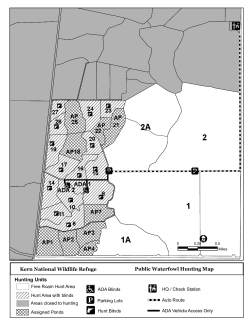
Map showing hunt zone, assigned ponds, free roam, and blinds at the Kern National Wildlife Refuge. Use this map for reference to see what hunt zones are open under the Hunt zone and Hunter quotas section.   

Attachments
AttachmentSize
Public Hunting Map_0.pdf522.36 KB522.36 KB
Publication date
Type of document
Refuge Map
Facility
Two ducks with reddish-brown heads, dark bodies, and long pointed tails swim together through open water between marsh plants.
Kern National Wildlife Refuge is the centerpiece of the Kern National Wildlife Refuge Complex. It is located 19 miles west of the city of Delano at the southern end of the San Joaquin Valley of California.
Program
A bright blue sky obstructed by fluffy white clouds reflected off of a stream shot from inside a kayak
The U.S. Fish and Wildlife Service manages an unparalleled network of public lands and waters called the National Wildlife Refuge System. With more than 570 refuges spanning the country, this system protects iconic species and provides some of the best wildlife viewing opportunities on Earth.
Ecosystem
Subject tags
Hunting
FWS and DOI Region(s)