Photo By/Credit
Bergeson, Mitch
Date Shot/Created
05/10/2012Media Usage Rights/License
Public Domain
Image
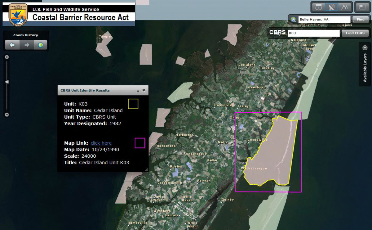
Image of the GeoCBRA Mapper, which is the portal for viewing digital map data of Coastal Barrier Resource System units and information. http://www.fws.gov/CBRA/index.html The John H. Chafee Coastal Barrier Resources System (CBRS) is a collection of specific units of land and associated aquatic habitats that serve as barriers protecting the Atlantic, Gulf, and Great Lakes coasts. The CBRS currently includes 585 System units, which comprise nearly 1.3 million acres of land and associated aquatic habitat. There are also 271 "otherwise protected areas," a category of coastal barriers already held for conservation purposes that include an additional 1.8 million acres of land and associated aquatic habitat. The Coastal Barrier Resources Act (CBRA) established the John H. Chafee Coastal Barrier Resources System (CBRS) in 1982. The CBRS consists of the undeveloped coastal barriers and other areas located on the coasts of the United States that are identified and depicted on a series of maps entitled “John H. Chafee Coastal Barrier Resources System.� These maps are controlling and indicate which lands are affected by the CBRA. The maps are maintained by the Department of the Interior through the Fish and Wildlife Service. Aside from three minor exceptions, only Congress has the authority to add or delete land from the CBRS and create new units. These exceptions include: (1) voluntary additions to the CBRS by property owners; (2) additions of excess Federal property to the CBRS; and (3) the CBRA 5-year review requirement that solely considers changes that have occurred to System units by natural forces such as erosion and accretion. http://www.fws.gov/CBRA/index.html 5/10/2012 General Rice Lake Emergent Vegetation Classification Rice Lake Emergent Vegetation Classification Inventory & Monitoring Achievement Tracker (IMAT) FY2011 Project Status Map Statewide stream prioritization based on 226 Maxent derived predictive habitat maps of aquatic organisms in North Carolina Potential contaminant sources in the Tualatin River watershed Guide Use Areas within Alaska Peninsula and Becharof NWRs Balcones Songbird Festival Family Events National Wetlands Inventory Status Map - April 2012 National Wetlands Inventory Wetlands Mapper National Wetlands Inventory Wetlands Mapper Coastal Barrier Resource Act - GeoCBRA Mapper