

Written By

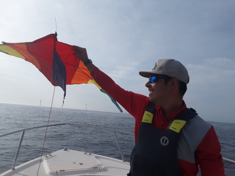
Pam Loring and Erik Carlson attached a GPS unit and a tiny radio transmitter to a rainbow-striped nylon kite and launched it from the back of a motorboat as they sped toward Block Island Wind Farm.
It wasn’t just for fun. Loring, a wildlife biologist for the U.S. Fish and Wildlife Service, and Carlson, a graduate student in astrophysics at the University of Rhode Island, were collecting data to inform the use of emerging technology for tracking migratory birds and bats at offshore wind farms — an industry that’s poised to take off.
Winds of change
In the next few years, wind farms will pop up all along the eastern seaboard of the U.S. The Biden Administration has committed to approving 16 offshore wind installations by 2025, with the hopes that offshore wind energy will power 10 million homes by 2030.
Once these wind farms are up and rotating, though, most will be barely visible from shore. If they’re visible at all. Many of the installations will be 20 miles or more from the coast.
But scientists who study migratory birds and bats can already picture those distant wind turbines dotting the horizon. And they see a research opportunity.
“As of now, it’s really challenging to study small-bodied birds and bats offshore,” said Kate Williams, Wildlife and Renewable Energy Program Director for the Biodiversity Research Institute. “There just aren’t a lot of options for tracking them over open water.”
While researchers can outfit large-bodied birds, like great black-backed gulls, with relatively hefty GPS transmitters to capture their movements, that’s just not going to fly for a piping plover or an eastern red bat.
The ability to track small-bodied species like these has improved on the mainland in recent years through the Motus Wildlife Tracking System, which deploys tiny, coded radio transmitters on birds and bats to study their migratory routes and behaviors. But that only works if those birds and bats fly within range of the Motus receiving stations dotting the North American landscape. That range is less than 10 miles.
“If a bird is farther than that from shore, we can only interpolate their flights based on when and where they were last detected on land, and when and where they show up on land again later,” Loring explained.
Wind farms can help bridge that gap by providing places to put Motus receivers offshore.
Connect the dots
Researchers envision building an entire offshore network of receiving stations to track birds and bats throughout the Atlantic region, filling a big geographic hole in what we know about the flight paths of migratory species. That information can help managers key in on important places to conserve stopover habitat on land so birds and bats can get enough fuel to travel long distances over water.
Knowing more about where migratory species do and don’t go can also inform the design and placement of future wind farms to ensure they don’t interfere with these arduous journeys.
That’s why the Biodiversity Research Institute, the U.S. Fish and Wildlife Service, the University of Rhode Island and Birds Canada (the developers of Motus) collaborated on an effort to optimize and standardize the use of Motus at offshore wind farms, by first testing the technology at one that already exists.
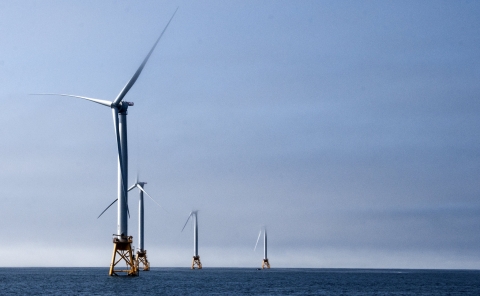
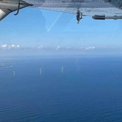
One of only two operational offshore wind farms in the U.S., Block Island Wind Farm is just a few miles southeast of the eponymous island near Rhode Island. It’s also already home to two Motus stations.
“We had a receiving station installed in 2017,” explained Brita Woeck, a permitting specialist for Orsted, the company that owns and operates Block Island Wind. In July 2021, the station was upgraded as part of the pilot project.
“The new receiving station has important advancements,” Woeck said. “It allows you to monitor the system and access data remotely, so you don’t have to send someone out there to physically check that it’s working or to download the data.”
Considering that most other wind farms will be much farther from shore than Block Island Wind Farm, those features will be key to the success of a future offshore Motus network.
But there are other determining factors as well. It’s not as simple as attaching a receiver to any old turbine and waiting for pings.
If it were, it wouldn’t require help from astrophysicists.
Radio check
That brings us back to the kite that Loring and Carlson set aloft with a GPS unit and a Motus transmitter. By simultaneously tracking the kite’s position with two different technologies, they could use the more precise one (GPS) to calibrate the other.
A Motus transmitter, or tag, doesn’t communicate a specific point — it gives off a radio wave signal, which is picked up by the antenna on a radio receiver. Scientists use triangulation to determine where the signal is coming from. (GPS works the same way, except the “points” in the triangle are satellites.)
This means there must be at least three Motus receiving stations within detection range to pick up a tag’s signal. In addition to the one attached to the easternmost turbine at Block Island Wind Farm, there are two others on Block Island proper that create the base of a triangle.
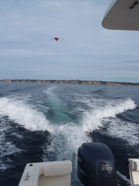
As Loring and Carlson motored through the waters around the wind farm with the kite soaring behind their boat, each receiving station picked up the signal from the tag. By comparing the signal strength and time of detection recorded at the three different receiving stations, they could narrow down the area where the tag could have been at any given point. The more receiving stations within range, the more accurate the result.
Carlson’s advisor at the University of Rhode Island, Doug Gobeille, who uses radio waves to track objects in space, likens it to gathering information about an event from people who were nearby when it happened. “They may not all have actually seen the event, so there will be some error in their perception,” he said. “But the more opinions we have to compare, the more we can reduce that error.”
Bird’s-eye view
The purpose of the calibration work is to figure out just how many receiving stations you need, and where you should put them, to get a consensus opinion on the tag’s location that’s similar to the one provided by GPS.
While kites do a good job of simulating movements of a bird or bat in flight, a kite can only go so high — about 300 feet in this case. The wind turbines at Block Island are 380-feet tall, and those at future wind farms may reach 500 feet or more. Because birds can cruise at altitudes significantly higher than that — thousands of feet — the team also needed a way to determine how altitude affects the signal from the Motus tags.
Peter Paton, a professor in the Department of Natural Resources Science at the University of Rhode Island, has long studied offshore bird and bat movements relative to wind developments. He conducted bird surveys by boat in the proposed lease area for Block Island Wind Farm before it was built, which indicated it was a relatively low-use area for the target species (and thus a good spot for a wind farm).
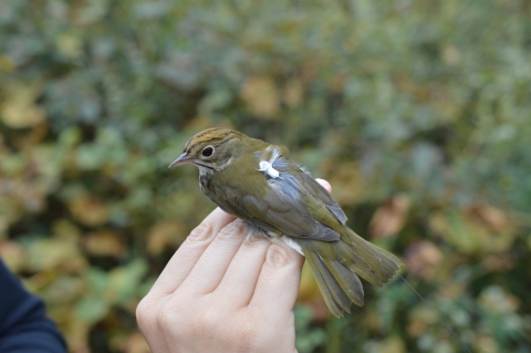
As part of the calibration study, Paton double tagged three nesting great black-backed gulls with GPS and Motus tags, figuring free-flying birds would be the best representatives for other winged creatures. But, the gulls often did not fly near the tracking towers. They seemed to have had other plans and moved out of the study area shortly after being tagged.
While drones might seem like the obvious second choice, the use of un-piloted aircraft systems by federal agencies for non-emergency purposes is currently prohibited. So the partners decided to use piloted aircraft instead, enlisting the help of the Civil Air Patrol — an all-volunteer U.S. Air Force auxiliary unit that often supports search-and-rescue operations.
Civil Air Patrol pilots conducted flight surveys with Motus tags over Block Island at different cruising altitudes, starting at 1,000 feet (the FAA minimum for flying over the ocean), all the way up to 4,000 feet.
“In an ideal world, we’d be able to get information at every altitude,” Carlson said. “But by combining the data from the kite and the planes, we can constrain mathematically the area where we’re still missing information.”
Range map
Carlson and Gobeille analyzed the resulting data to develop a three-dimensional map of the detection range of each station, which was fed into a guidance document — funded by the New York State Energy Research and Development Authority — for using this technology offshore.
To make that guidance more user-friendly, the Biodiversity Research Institute created a complementary study-design tool.
“The free, online tool will help offshore wind developers figure out how many Motus stations they would need, and where, to provide good detection coverage of a potential wind farm’s footprint,” Williams of the Biodiversity Research Institute explained.
The Bureau of Ocean Energy Management — the agency that oversees wind farm development in federal waters — is working with the Service and industry partners, such as South Fork Wind Farm and Vineyard Wind, to plan and implement post-construction bird and bat monitoring programs at installations throughout the Atlantic coast.
And the Motus research partners want to be ready.
“For those developers that do conduct monitoring, we want to make sure the technology is scientifically supported and consistently applied between locations so we can build a regional-scale picture of the offshore movements of these species,” Williams said.
On the horizon
The pilot project at Block Island Wind Farm is an indication that developers may be eager to participate. Orsted was required to do monitoring at Block Island Wind Farm for a period of time after construction, but that period is now complete. Installing the new Motus receiver and providing site access and support for the calibration study was voluntary.
“The pilot at Block Island will have direct implications for the use of this technology across the offshore wind industry, and we’re excited about the work of the partners to get it to commercial readiness,” Orsted’s Woeck said, adding, “We wouldn’t be able to do that on our own — that’s why this kind of collaboration is so important.”
The final products of this effort are available online at: https://briwildlife.org/offshore-motus-guidance/


