

Written By

Chatsworth, Georgia – If any river is worth saving, it just might be the Conasauga.
It flows free of dams from the Cohutta Wilderness high country into Tennessee before returning to Georgia to meander past hay fields, cow pastures, chicken coops, and carpet-making towns. The river – a biodiverse gem -- holds an exceptional number of fish, mussel, snail and crayfish species, including a dozen listed as threatened or endangered.
The Conasauga sits atop the mighty Coosa River basin and pumps much-needed mountain water into the rivers and reservoirs that reach from northwest Georgia through central Alabama and into the Gulf of Mexico. Three-dozen conservation agencies have spent more than three decades and millions of dollars working to polish the Conasauga’s luster. The U.S. Fish and Wildlife Service is, again, considering creating a wildlife refuge along the upper reaches of the Conasauga in Georgia and Tennessee.
Is it worth it? Should so much attention and money be spent on a river that turns foul long before it reaches the Coosa or Alabama? What good are relatively clean headwaters when there is pollution downstream and in its tributaries? How can the Service and other groups, with scant resources and stiff competition for that money, work to save near-extinct species?
“If you had the chance for safe drinking water, is it worth it? If you had the chance to preserve all this pristine beauty is that worth anything? Is protecting species that live in only one place on earth worth anything?” asks Stephen Bontekoe, the executive director of the Limestone Valley Resource Conservation and Development Council. “God put man on earth and said, ‘Take care of it.’ So, it’s incumbent upon me, as a human being, to care for the creation that we’ve been entrusted with.”
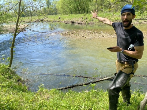
Bontekoe, Fish and Wildlife, and a slew of conservation partners are currently focusing restorative efforts on Holly Creek, an idyllic-looking tributary of the Conasauga. They’re bolstering stream banks, keeping cows from the water, reintroducing scores of endangered mussels, and replacing culverts with more fish-friendly passages. Success, so far, can be measured by the number of landowners signed up to restore the creek.
“This used to be a pretty bad spot. The cows were in the creek and it was just bare dirt down there,” says Joe Kirsch, a biologist with the Service’s Partners for Fish and Wildlife Program, while surveying Holly Creek. “But now the cows are out of the creek, there’s vegetation on the ground, and we’re keeping sediment out of the water. We’re already having an impact on the riparian riparian
Definition of riparian habitat or riparian areas.
Learn more about riparian corridor. But it could be five to 40 years ‘til we get a biological response from the fish and mussels. Some of these mussels are slow growers. So, it’s going to take time.”

'A priceless asset’
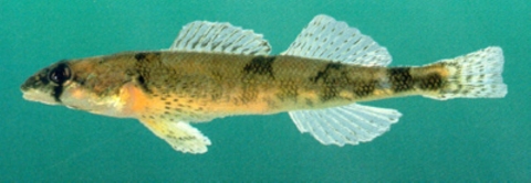
The Conasauga’s aquatic biodiversity is unique across North America. Ninety different species of fish, including many that have disappeared from lower reaches of the Coosa, abound. Two are federally listed as endangered (amber darter, Conasauga logperch) and one is threatened (blue shiner). The river is a malacologist’s dream. Of the 25 different mussel species, a half-dozen are threatened or endangered, including the Alabama moccasinshell and Southern pigtoe.
Katie Owens, with The Nature Conservancy (TNC), labels the Conasauga “the Holy Grail for species.” The Service considers it “a priceless asset.” Jesse Demonbreun-Chapman, executive director of the nonprofit Coosa River Basin Initiative, says “this tiny river has more aquatic species than all the rivers in Europe combined.”
But they’re disappearing.
The U.S. Geological Survey and the University of Georgia reported in 2017 on the “declining species richness” along the Conasauga. All 26 species monitored over 20 years showed declines in overall numbers. Three species – the Coosa chub, Coosa madtom, and tricolor shiner -- weren’t even recorded the last five years, the study says, “essentially disappearing from the monitored sites.”
The researchers conducted another study in 2020, this time focused on the endangered amber darter. Increasingly, between 1996 and 2018, surveys failed to detect any amber darters in the Conasauga and another nearby river.
“Given that these rivers are thought to constitute the entirety of the species' range, these results imply that the amber darter is on a trajectory toward extinction,” the report concludes.
The Conasauga started getting some serious love in 1995 when the Limestone Valley council received a $200,000 grant from USDA's National Resources Conservation Service (NRCS) to study the river and all its sediment, nutrient, and toxic nastiness. The Conasauga River Alliance – a loose assemblage of 36 federal, state, local, regional, nonprofit, university, utility, and aquarium groups -- formed five years later to tackle restoration work across the 500,000-acre watershed.
Work, and money, centered on the river’s upper reaches and tributaries like Holly Creek. USDA, via the Forest Service and NRCS, has undertaken maybe 50 projects across the upper Conasauga. They’ve built miles of stream buffers, installed dozens of compost houses for chickens, and improved or replaced septic systems. Along the headwaters of Holly Creek, the Forest Service has replaced numerous culverts, fixed bridges, and deployed riprap to slow the creek’s flow.
TNC, in 2005, created a 250-acre preserve near the headwaters of Holly and Dill creeks and surrounded on three sides by the Chattahoochee forest. Holly Creek is something of “a miniature research site,” Owens says, where the nonprofit focuses on water quality and returning mussels to their original habitat.
Bontekoe, with Limestone Valley, works with farmers whose fields, cows, and crops pollute the creek. They may lose a couple of feet of pasture and wetland each year to erosion and floods. Bolstering creek banks with stakes and vegetation slows erosion. Farmers may also switch from fertilizer-heavy crops to hay and fence their feces-producing cows off from the water. Bontekoe, a farmer himself, helps neighbors obtain state and federal grants that pay for the water-quality work.
Demonbreun-Chapman is also the Upper Coosa Riverkeeper which enforces the Clean Water Act. His nonprofit aims to clean up pollution at its source via education, advocacy, and, sometimes, legal action. He also works alongside public and private partners to fence off cattle, stabilize streambanks, and restore waterways. Matching worthy projects with state and federal moneys, though, is perhaps the nonprofits’ most critical task.
“The goal,” Demonbreun-Chapman says, “is putting the right money on the right project.”
'People starting to line up’
The Ward Farm has been in the family since the Civil War, cultivating hundreds of acres in the valley that backs up to the national forest.
“This is just pure mountain water,” says Frank Ward whose 200-acre spread runs along Holly Creek. “If anything gets into it in the forest, it’s just bears or deer.”
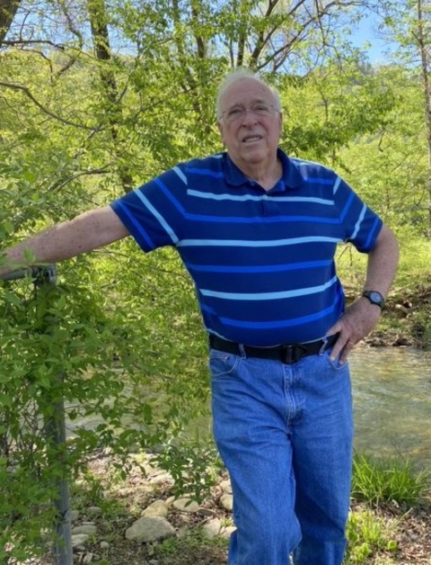
The water itself, though, is destructive. More frequent, and more damaging, surges of water cascade down the Cohuttas, eroding the streambank and uprooting Ward’s trees. His garage, too, was threatened.
Kirsch, along with Limestone Valley, the Coosa River Basin Initiative, and the state of Georgia, got busy. They cut yellow locusts from a nearby pasture, piled them into the ground and layered them with other trees, rocks, dirt, and a coconut-fiber mesh to keep vegetation in place. A 50-foot wide buffer of grasses, plants, and trees now lines the creek and fortifies nearly two acres of Ward's property.
“I’m really excited the way this turned out. It's stabilized the banks and stopped them from washing away,” Ward says.
The Partners program spent $60,500 on the Kirsch-managed project. Neighboring farmers took notice of the work, and the financing.
“As you start to invest in these areas with people who care, it’s contagious,” the Partners biologist says. “You get people starting to line up. Frank is going to help sell us to his neighbors.”
Up a bit from Ward’s farm, at the edge of the national forest where the blacktop ends, a bridge needs replacing. Again. Culverts, previously, kept fish from getting up Dill Creek to spawn. (Mussel larvae piggyback on fish to find prime spawning grounds too.) The Dill Creek bridge was built in 2010 with hopes of easy fish passage fish passage
Fish passage is the ability of fish or other aquatic species to move freely throughout their life to find food, reproduce, and complete their natural migration cycles. Millions of barriers to fish passage across the country are fragmenting habitat and leading to species declines. The U.S. Fish and Wildlife Service's National Fish Passage Program is working to reconnect watersheds to benefit both wildlife and people.
Learn more about fish passage . But it’s not long enough. Scouring from heavy rains washes out more than a foot of embankment each year and threatens to collapse the bridge. And the scouring pushes the riprap and sediment into Holly Creek which further impedes animal traffic. The Federal Highway administration will foot the $2.3 million replacement bridge.
Holly and Dill creeks could be pieces of a new wildlife refuge. In 2009, the Service laid out an 18,750-acre “acquisition boundary” -- within which a refuge would grow – along the Conasauga stretching from the western edge of the Chattahoochee forest into Tennessee and down to Dalton. Eighty percent of the boundary lands are forested or farmed. A 100-foot buffer along both sides of the river would be protected. A 2014 draft plan noted that more than one-fourth of the river’s basin was already protected by national forests, state-owned lands, three mitigation banks, and TNC. The Service even put a price tag -- $20 million over 10 years – on a possible 10,000-acre refuge.
With money tight, the proposal languished. Two years ago, though, the Service suggested that a refuge could be built with “a patchwork of options,” including land purchases, already protected lands, and conservation easements whereby landowners retain title to their property but agree to conserve it. Peter Maholland, the Service’s field supervisor for Georgia, says a refuge “is not off the table, but is on hold at the moment” as the agency conducts a watershed-wide analysis of possible conservation lands. Meanwhile, TNC is currently buying 347 acres along the Conasauga.
'Parameter for success’
Stuff, as we know, flows downstream. The lower down the Coosa, the worse the water quality. E. coli-carrying chicken feces, much of it spread on fields as fertilizer, leaches into the river system. Sewage overflows from Chatsworth, Dalton, Calhoun and other towns harm water quality. A half dozen dams across the Coosa basin block the movement of spawn-seeking fish and mussels. And, recently, the water utility in Dalton, along with a few of the world’s largest flooring manufacturers, agreed to pay at least $159 million to the city of Rome to settle a lawsuit claiming toxic chemicals leaching into the Conasauga contaminated the city’s water.
Last year, American Rivers ranked the Coosa as the nation’s fifth “most endangered” river.
“The listed species, mostly mussels and fish, you only see upstream of Dalton,” says Owens, who has been the Upper Coosa Program Director for TNC since 2007. “Our priority zone is, really, the Conasauga north of Dalton. And I don’t see that changing anytime soon.”
But even if the free-flowing Conasauga’s headwaters are protected, and the critters conserved, the lower stretches of the Coosa basin will still suffer. So, why bother fixing the head if the body fails?
Owens offers a better analogy.
“If somebody’s going to have a heart attack, you go in there and check all the different arteries that feed into the heart. If all the capillaries in the chamber are blocked it’s going to lead to catastrophic failure,” she says. “Now, look at a map of a river and all the smaller streams that flow into that river. You can’t work on big rivers and expect to make a difference unless you’re fixing all the smaller tributaries first. Holly Creek is a great place for us to work.”
Adds Bontekoe with Limestone Valley, “Why take care of your own yard if somebody five miles down the road doesn’t? You take care of what’s in your control. You do your part and that’s contagious. It’s incumbent upon us to do what we can where we are, regardless of conditions beyond our control.”
Case in point: In March, Fish and Wildlife declared the Conasauga’s frecklebelly madtom, a smallish catfish, a threatened species and designated 134 river miles as critical habitat.
The conservation contagion has spread across the upper Conasauga. Bontekoe says about seven miles of Holly Creek, for example, has been conserved via fencing, buffers, culverts, crop changes, bank stabilizations, mussel plantings, farmer buy-ins, strong partnerships, and more.
“We’ve hit a fever pitch where we’ve got great momentum” he says. “We’re starting to really have critical mass in addressing the issues. We’ve created the parameters for success.”


