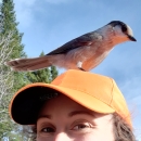
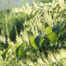
The technician will spend about 80% of their time working on mapping and controlling invasive species invasive species
An invasive species is any plant or animal that has spread or been introduced into a new area where they are, or could, cause harm to the environment, economy, or human, animal, or plant health. Their unwelcome presence can destroy ecosystems and cost millions of dollars.
Learn more about invasive species . Approximately 25 non-native invasive plant species will be mapped at Rachel Carson and Great Thicket NWR in southern Maine. Lands are surveyed on the ground using an established 50×50 meter grid system, and information about species presence, abundance, growth stage, and more, are recorded using ESRI Field Maps with an iPad. It is preferred that the intern have some experience managing invasives and collecting data in Arc GIS Online (AGOL).
Author(s)
Helen Manning
Publication date
Type of document
Brochure
Facility

Media Usage Rights/License
Public Domain
Program

Species
FWS and DOI Region(s)