

Visit Us
Adjacent to the city of Gaston, near Portland, Oregon, Wapato Lake National Wildlife Refuge (NWR) offers a sanctuary for wildlife and humans alike. Visitors can enjoy a diversity of wildlife and view different habitat types, including expansive wetlands, riparian riparian
Definition of riparian habitat or riparian areas.
Learn more about riparian corridors, and mixed forests.
Potential for Limited Access Due to Rain
Please be aware that during periods of heavy rain, Wapato Creek can flood the paved trail leading to the bridge that provides visitor access to the refuge, making it impassable. Check the water level using this USGS Monitoring Tool to decide about making the visit to the refuge. When the graph indicates that the creek is approximately 7.5 feet or greater, the trail will be flooded. Refuge staff are actively working on solutions to this issue.
Know Before you Go
Trail and parking lot are open daily from sunrise to sunset, February 1 through November 30, for approved activities. From December 1 – January 31, trails are only open to refuge-permitted hunters. There are lots of opportunities to enjoy this refuge, and visitors will be able to see variations of wildlife and plants throughout the seasons. Go here for accessibility and site information. There is extremely limited shade along the trail, so make sure to bring plenty of water and snacks, no matter the season. Plan for sun protection in the summer months, and rain gear in the winter and rainy months is highly encouraged.
Please review our trail information before visiting – due to refuge waterfowl hunts and Oregon state hunts, specific trail closures are in effect during portions of the year.
Wapato Lake National Wildlife Refuge Public Access Plan Finalized
The U.S. Fish and Wildlife Service has completed the final environmental assessment for the public access plan for Wapato Lake National Wildlife Refuge. The public access plan opens the refuge to new activities, specifically wildlife observation, wildlife photography, environmental education, and interpretation. The refuge will be open for wildlife observation and photography, environmental education and interpretation from February-November, seven days a week.
In addition to the new activities for the public, the refuge is also open to hunting. From February through September, the full 2.6-mile levee trail and 0.25-mile paved entrance trail is open to the public. During October and November, while the state waterfowl hunting season occurs on privately owned lands adjacent to the refuge, the 0.25-mile of paved entrance trail and the northern 1.3 miles of the levee trail are open to the public. To ensure the safety of all visitors and in response to public comments on the draft public access plan, during the months of December and January, the refuge will only be open to waterfowl hunters participating in the state season on refuge lands with refuge hunting permits on Tuesdays, Thursdays, and Saturdays. Access to hunters is limited to the northern 1.3 miles of the levee trail.
The Draft Public Access Plan and accompanying Draft Environmental Assessment were open for public comment from December 1st, 2021 through January 31st, 2022. Staff reviewed all public comments to determine if any changes were necessary to the Draft Public Access Plan. Responses to all public comments are included in the final public access plan and environmental assessment. The refuge will open to the public on October 1st, 2022.
The Final Public Access Plan and Environmental Assessment can be accessed here.
The News Release can be accessed here.
Frequently Asked Questions on Public Comments and the Final Public Access Plan and Environmental Assessment
Where can I find responses to a comment I submitted on the draft plan/EA?
Responses to all public comments are in Appendix C. Response to Public Comments on the Draft Plan and EA in the Final Public Access Plan and Environmental Assessment.
Which alternative from the draft plan was selected (final preferred alternative)?
In response to public comments regarding safety and hunting access, the Service developed a new preferred alternative (Alternative B, with modifications) that combines elements of Alternatives A and B to minimize potential for conflicts between the general public and waterfowl hunters on or near the refuge during the hunt season, while maximizing opportunities for public access while levee repairs and lakebed restoration are ongoing.
Under the new preferred alternative, from February through September, the public may walk/hike on the full 2.6-mile levee trail and 0.25 mile paved entrance trail seven days per week, during daylight hours only (from sunrise to sunset). During October and November, while the state waterfowl hunting season occurs on privately owned lands adjacent to the refuge, and before levee repairs are completed (estimated in 2027), the public may walk/hike on 0.25 mile of paved entrance trail and the northern 1.3 miles of the levee trail seven days per week, during daylight hours only. The southern 1.3 miles of the levee trail would be closed to public access to minimize potential for off-site hunting conflicts and to establish sanctuary for waterfowl during the hunt season. During December and January, Refuge access would be limited to only selected hunters and their parties on Tuesdays, Thursdays, and Saturdays, and the entire levee trail would be closed to all other public access.
As restoration progresses, changes in water levels may impact the hunt season and other public access periods. We will continue to collect data on water levels, wildlife, and public use to determine if changes to the hunt or public access is warranted. Any proposed changes would be evaluated in a separate review, and if necessary, NEPA document. We would notify the public before changes to public access take place.
Accessibility Information
Site Specifics and Amenities
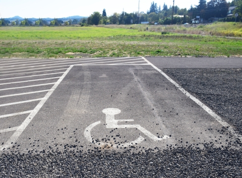
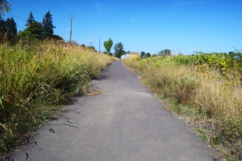
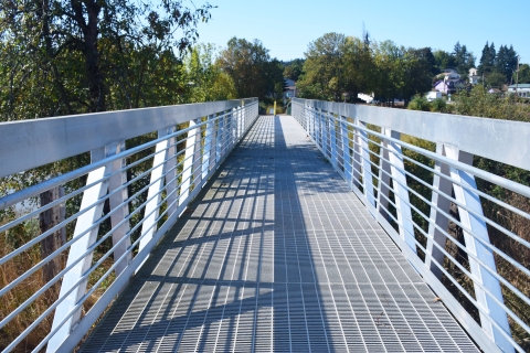
If arriving by car, there are two ABA parking spaces; in front of the two spaces there is a portable restroom. Follow the paved path to the kiosk sign for site information; continue on the paved path to a paved incline that transitions to pedestrian bridge (graded metal material). There is a slight transition from the bridge to the small compacted gravel trail. Head to our Trail Descriptions for further information. There is extremely limited shade along the trail, so make sure to bring plenty of water and snacks, no matter the season. Plan for sun protection in the summer months, and rain gear in the winter and rainy months is highly encouraged. There are currently 2 benches along the trail, located at approximately 0.75 miles south from the trail split, and another bench located 2 miles south of the trail split.
Activities
The abundance of wildlife and wetland views offers many opportunities for nature photography, wildlife viewing, and birding. Hike our trails to follow the lakebed and see extended views of wetland and riparian riparian
Definition of riparian habitat or riparian areas.
Learn more about riparian habitat. Please note specific trail closures due to refuge waterfowl hunts and Oregon state hunts – these trail closures will impact not only hiking, but the activities that depend on access to the trails, such as wildlife observation and photography.
Trails
Hike our trails to follow the lakebed and see extended views of wetland and riparian riparian
Definition of riparian habitat or riparian areas.
Learn more about riparian habitat. Please note the open periods for each trail; trail closure periods are due to refuge waterfowl hunts and Oregon state hunts – these trail closures will impact not only hiking, but the activities that depend on access to the trails, such as wildlife observation and photography.
Trail Name: Gravel Trail
Open Season: Feb 1- Nov 30
Length: 1.1 miles
Location of trail: Access trail from parking lot by following paved path from parking lot up to trail, where visitors will reach a fork; go left to access the northern portion of the gravel trail, and head right to access the southern portion of the gravel trail, and the natural trail.
Surface: Gravel
Difficulty: Easy
Information: This trail is out-and-back in both directions and a total of 1.1 miles in length. The path skirts the lakebed, which offers visitors sights of water filled with waterfowl in the winter and an expanse of vegetation during the summer months.
Seasonality and weather considerations: There is extremely limited shade spots along the trail, and limited benches on this portion of the trail, at this time. Please be prepared for heat in summer months, and for wet and cold weather in the winter months.
Trail Name: Natural Trail
Open Season: Feb 16 - Sept 30 (Updated 2026)
*This trail will reopen after Feb. 15, due to state goose hunting season and hunting that may occur on surrounding private land
Length: 1.3 miles
Location of Trail: Access trail from parking lot by following paved path from parking lot up to trail. Walk along southern portion of Gravel Trail for 0.7 miles until natural trail.
Surface: Uneven, natural surface (soil, low-growing plants, rocks, etc)
Difficulty: Easy
Information: This trail is out-and-back, and a total of 1.3 miles in length. The path skirts the lakebed, which offers visitors sights of water filled with waterfowl in the winter and an expanse of vegetation during the summer months.
Seasonality and weather considerations: There is extremely limited shade spots along the trail, and limited benches on this portion of the trail, at this time. Please be prepared for heat in summer months, and for wet and cold weather in the winter months.
Other Facilities in the Complex
A National Wildlife Refuge Complex is a grouping of two or more refuges, wildlife management areas or other refuge conservation areas that are generally managed by a central office location. Refuges are grouped in a complex because they occur in a similar ecological region (like a watershed or habitat type) and have a related purpose and management needs.
Wapato Lake National Wildlife Refuge, with Tualatin River National Wildlife Refuge, forms the Tualatin River National Wildlife Refuge Complex. Tualatin River National Wildlife Refuge currently serves as the Complex headquarters, and staff work to manage both refuges. Wapato Lake National Wildlife Refuge became an official refuge in 2013, but has been closed to the general public and most public use activities until 2021.

Rules and Policies
In order to provide and maintain our wildlife refuge as a home for a variety of wildlife, we ask that you follow our rules and guidelines while visiting and walking our trails.
Locations
To main parking lot, from Portland: Head to Hwy 26W; remain on freeway and take exit 57 for Glencoe Rd, toward North Plains; turn left onto 1st St/NW Glencoe Rd; turn right onto NW Zion Church Rd and continue onto NW Cornelius Schefflin Rd; at traffic circle, take 1st exist onto NW Verboort Rd; at next traffic circle, take 3rd exit onto NW Martin Rd; turn left onto OR-47; at city of Gaston (approximately 12 miles after turning onto OR-47), follow signs and turn left into parking lot.