About Us
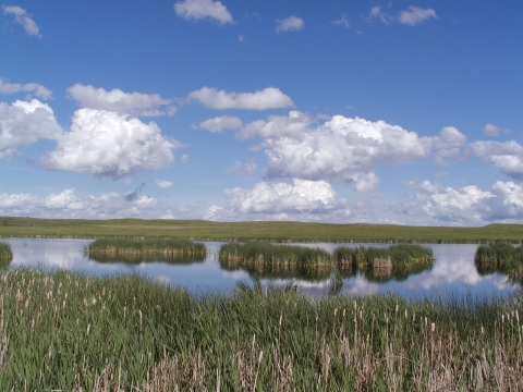
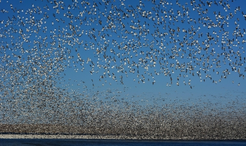
Huron Wetland Management District was created on May 31, 1992. The district was established encompassing lands that were previously under the management of both the Lake Andes and Sand Lake Wetland Management Districts. The Huron Wetland Management District covers eight counties in east-central South Dakota and is headquartered in the town of Huron, South Dakota. The District consists of 59 waterfowl production areas, totaling 17,683 fee owned acres, in Beadle, Sanborn, Jerauld, Hand, Hyde, Hughes, Sully, and Buffalo counties. The topography in the eastern counties of the district is relatively flat. The landscape transitions, as you move further south and west, to the Missouri Coteau slope. The Missouri Coteau is the rolling hills that were formed by glacial till as glaciers receded after the ice ages. The District lies in the midst of the world renowned prairie pothole region. The prairie pothole region is named for the millions of depressional wetlands dispersed throughout the landscape. Millions of waterfowl and shorebirds travel through and nest in the prairie pothole region.
The waterfowl production areas are a part of the National Wildlife Refuge System. National wildlife refuges and waterfowl production areas are vitally important to wildlife and people. These lands are managed to provide habitat for endangered species, migratory birds, and other wildlife They also provide places for people to hunt, fish, learn about, and enjoy wildlife. Waterfowl production areas are open to many public activities year-round. Access to waterfowl production areas is by foot travel only or vehicles in the designated parking areas. Visitors to waterfowl production areas can expect to find a rich variety of plant and animal life. Waterfowl production areas are not open for overnight camping.
The District staff also works with private landowners to administer the wetland easement and grassland easement programs. The Huron Wetland Management District easement program consists of 308,909acres of wetlands and grassland that are permanently protected. Each year the number of acres protected grows with the help of willing landowners who sign their lands into easements.
Our Mission
Each unit of the National Wildlife Refuge System is established to serve a statutory purpose that targets the conservation of native species dependent on its lands and waters. All activities on those acres are reviewed for compatibility with this statutory purpose.
Our History
The Huron Wetland Management District is a mixture of prairie grasses and shallow wetlands. An abundance of wildlife call these areas home. Buffalo, pronghorn antelope, whitetail deer, ducks, and geese were here in great numbers. Both Native Americans and white settlers depended on the wildlife in this area for food and other uses. As settlement of the prairies accelerated, settlers looked for ways to increase production of row crops. Thus, the drainage of prairie pothole wetlands began. The drainage of wetlands continued unabated until the adverse impacts were very evident. Wildlife numbers began to decline and flooding increased downstream. The combination of drainage, unregulated sport hunting, market hunting, and collecting feathers for the fashion industry had disastrous effects across the landscape. In response, the United States Congress appropriated funding to stop the destruction of wetlands, vital tot he survival of migratory birds. Thus the duck stamp act of 1934 was born. The act requires all waterfowl hunters ages 16 and over to purchase a Federal Duck Stamp annually. The majority of the Waterfowl Production Areas and Service easements would not exist today without the funding from sales of the Federal Duck Stamp. Every person who buys a Federal Duck Stamp is lending a helping hand to habitat conservation in America.