An official website of the United States government
Here’s how you know
Official websites use .gov A .gov website belongs to an official government organization in the United States.
Secure .gov websites use HTTPS A lock ( ) or https:// means you’ve safely connected to the .gov website. Share sensitive information only on official, secure websites.
The recreational beach parking lot after being flooded and destroyed in a 2015 storm.
Assateague Island is on the move. As a result of natural processes, the island is approaching the mainland at a rate of approximately 10-13 feet/year. Large storm events accelerate the process and lead to costly repairs and long-term closures of public parking areas.
More than $15 million has been spent for storm recovery since 2003 - including as much as $400,000 per year on repeated maintenance costs.
The refuge, owned and operated by U.S. Fish and Wildlife Service, and the recreational beach, managed and operated by National Park Service, attract more than 1 million visitors annually. Closure of the parking areas due to storm damage reduces the ability of the USFWS and NPS to provide recreational beach access and interpretive opportunities to these visitors.
The parking area is easily breached during severe storm events like this storm in 2015.
Over a multi-decade public planning and engagement process, the agencies carefully considered substantial public input and comments that informed the current strategy. Moving the recreational beach to a more stable location north of the existing beach was the only available course of action that could conserve wildlife resources on the refuge, significantly reduce annual and long-term maintenance costs, and protect the viability of the local economy.
$17.7 million in funding for this project was obtained in 2022 via a U.S. Department of Transportation Federal Highway Administration Nationally Significant Federal Lands and Tribal Projects grant.
Status
Completed
Design and Permitting at 100%
The Air National Guard (ANG), through the Department of Defense Innovative Readiness Training Program, assisted in the construction for a period of 16 weeks. Through their efforts the project made a substantial start in 2025.
Parking lots and walkways to the beach have almost reached completion and amenities will be installed during the Fall/Winter of 2026/27
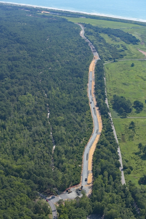
Road base materials have been installed for approximately 1 mile of the 2.25 mile road.
A contract to complete the new road and multiuse path was awarded in September 2026 with a planned completion date of March 31, 2027 .
Anticipated Timeline
Construction of roads, roundabouts and multiuse path: October 2026 - March 2027
Construction of visitor amenities: anticipated Fall 2026 - April 2027
Opening of the new recreational beach area - Potentially the Spring of 2027 (Dependent on construction activities completed during 2026/27)
An aerial view of the parking lot progress. Photo by Patrick J Hendrickson/Highcamera.com
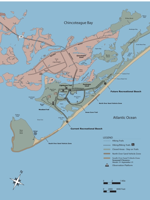
New Beach Location
2.5 miles north of the current site
Mile long, similar to length of current beach area
Maintaining the approximate 961 space parking capacity + RV spaces
7 Boardwalks will connect the new parking lots to the beach area
Potential of Construction Impacts to Visitors
Increased truck traffic in the Town of Chincoteague and on the refuge throughout the course of this work. Traffic delays and detours along Beach Road and the recreational bike trail are possible.
Restricted access to the Service Road including temporary closures, suspension of bus tours, or access to associated areas may occur in the future.
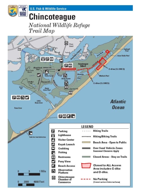
As of April 1, 2026, the Service Road will remain open to foot and bike traffic as normal. There may be times when sections of the Service Road or construction area is temporarily closed to all public use for safety during construction.
As of April 1, 2026, the beach access points on D-Dike will be closed for safety reasons during construction. Foot and bike beach access is still available at the existing recreational beach at the end of Beach Road and Swan Cove Trail. There are no restrooms north of Swan Cove Trail.
On September 1, 2026 the North OSV area closed as the South OSV area reopened.
Habitat Restoration Projects
Swan Cove Salt Marsh Restoration
This previously designed project, in partnership with Ducks Unlimited and the US Army Corps of Engineers, is currently in the permitting phase. The project will create approximately 295 acres of salt marsh salt marsh Salt marshes are found in tidal areas near the coast, where freshwater mixes with saltwater.
Learn more about salt marsh habitat in Swan Cove using beneficial re-use of dredge spoils from the Chincoteague Inlet dredging project. This marsh creation will restore historical hydrology to the area, build resiliency in the face of mounting threats, and increase habitat for marsh nesting birds, fish, and shellfish. This project involved depositing a thin layer placement of fill in the mudflats of Swan Cove and will then be graded and planted with grasses to match surrounding marsh elevation. This project is planned for construction in late 2027 through 2029.
Frequently Asked Questions (FAQ)
Will the existing recreational beach be closed during construction?
The existing recreational beach will remain open until the construction efforts for the new beach are complete. We anticipate no interruptions to beach access from construction, but the site could be subject to temporary closures caused by weather, NASA launches, or other safety-related events.
How will this impact OSV use?
South OSV area: Once closed in conjunction with the new recreational beach site, this area will remain closed March 15th thru September 15th each year. It will reopen each year from September 16th thru March 14th for wildlife dependent activities. North OSV area: Once reopened in conjunction with the new recreational beach site, this area will remain open year-round.
What will happen to the current beach and parking lot location?
Once the new recreational beach facilities are completed and open, the current beach will be managed as natural beach, dune, and saltmarsh habitats. We anticipate that working with nature will allow for the natural barrier island process to occur, creating habitat for threatened and at-risk species and offering protections to the local community from future storms.
How will this project impact wildlife?
Allowing for natural processes to occur at what is now the recreational beach and parking lot will create habitat for multiple priority beach nesting birds including American oystercatcher and piping plover. Construction of the new recreational beach will be timed to minimize disturbance to wildlife.
How will the new beach be accessed from the parking areas?
Once the new recreational beach facilities are completed and open, there will be 7 boardwalk trails leading visitors through woods, scrub, and dune meadow habitats between the parking areas and the beach. At least one trail will be designed to meet Architectural Barriers Act (ABA) requirements and will be located near ABA-accessible parking spaces. Visitors may be able to spot native songbirds and other wildlife along the newly constructed trails, estimated between 325-475 feet in length between the edge of the parking lot to the top of the beach dune.
This final Comprehensive Conservation Plan for the 14,032-acre Chincoteague National Wildlife Refuge and 373-acre Wallops Island National Wildlife Refuge is the culmination of a planning effort involving Virginia state agencies, Federal partners including the National Park Service, local...
This Environmental Assessment analyzes the proposed action for the site design of the facilities needed to support the relocation of the recreational beach, as described in the August 2015 Final Comprehensive Conservation Plan and Environmental Impact Statement and approved by the Record of...
PDF
You are exiting the U.S. Fish and Wildlife Service website
You are being directed to . The page will open in a new window.
We do not guarantee that the websites we link to comply with Section 508 (accessibility requirements) of the Rehabilitation Act. Links also do not constitute endorsement, recommendation or favoring by the U.S. Fish and Wildlife Service.
Click 'I understand' to proceed. Click Cancel to stay on the FWS website.