Non-Motorized Boating
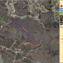
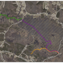
There are 3 paddling trails on the refuge: the Green Trail (upper Blackwater River) the Purple Trail (central Blackwater River), and the Orange Trail (central Blackwater River and Coles Creek). A map of the refuge water trails can be found below.
NOTICE TO BAY BOATERS: There is a safety zone around and adjacent to Barren Island during the construction of breakwaters. Please see the bulletin below for details. To find out more about the construction at Barren Island, please visit this website.
Water trails are open daily, dawn to dusk. The Purple Trail is closed seasonally October 1st - March 31st to limit disturbance to wintering waterfowl. The Purple and Green Trails can be accessed at the refuge's soft launch on Route 335 at the Blackwater River Bridge. The Purple and Orange Trails can be accessed at the Shorters Wharf public boat ramp on Maple Dam Road.
In addition, there is a soft launch on Key Wallace Drive directly adjacent to the Little Blackwater River Bridge, allowing access to the Little Blackwater River. Vehicles are only allowed to park temporarily while loading or unloading watercraft. This launch is closed during the seasonal refuge waters closure Oct. 1st - March 31st.
The Orange and Purple Trails generally have the highest overall salinity and the lowest diversity of plant species. Big cordgrass and saltmarsh cordgrass thrive here. In late July and August, marsh hibiscus is covered in white and pink blooms. On the Green Trail, the marsh ranges from slightly brackish to fresh water. During summer, fragrant waterlily covers much of the water and narrow-leaved cattail grows at the water's edge.
Wayfinding Maps
Wayfinding maps for Blackwater’s water trails are available using smartphone apps that support geospatial PDF files, such as FO MAPS (FaenaOffline). These apps use your phone’s GPS to find your location, and work without a signal from your carrier. They are available for Apple and Android devices. After installing the app on your phone, download the Blackwater Geospatial Paddling Map below to use with the app while paddling the refuge's water trails. Learn how to use the maps here.